A summary with the permission of Jean-Philippe Goiran and his team 1
to the Porta Romana in Ostia
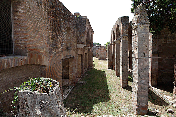
Among all ports of Rome, the most important port of course was Rome’s own port Ostia (see 'A Harbour for Rome'). After a long history of excavations, today Ostia is one of the largest and most interesting archaeological sites in Italy. We know a lot about Ostia. Many researchers explored and described the city. Nevertheless one of the most fundamental aspects of Ostia remained unsolved. Ostia was built as a harbour city, but was there a true harbour, a basin, apart from the Tiber quays?
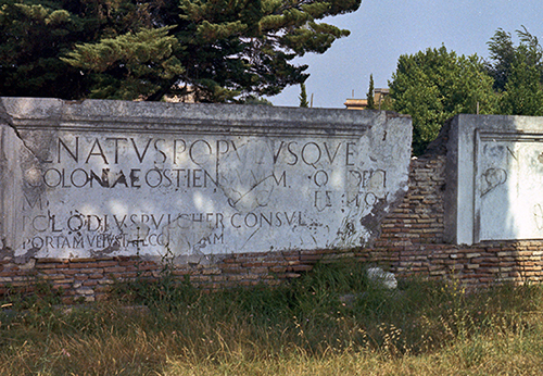
We know that the emperor Claudius built a new harbour at Portus between 42 and 54 AD, and Ostia functioned as a commercial centre for the new harbour. All over Ostia you can find symbols and inscriptions about Portus, but almost nothing about her own harbour.
Why was it so difficult to locate a harbour basin?
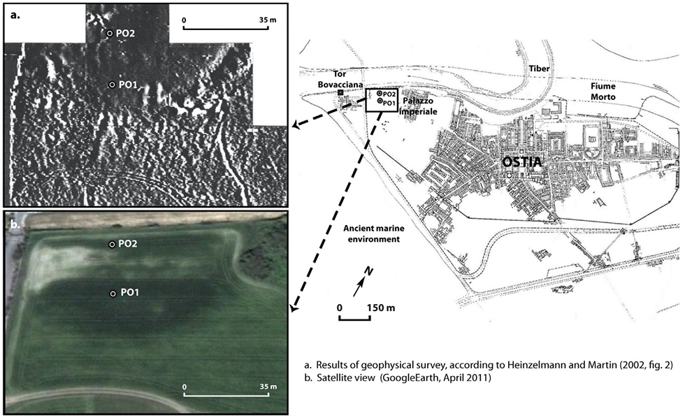
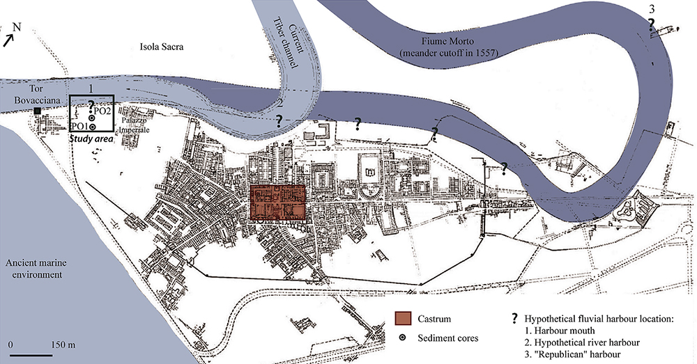
Of course many attempts have been carried out to locate the ancient harbour basin of Ostia at the mouth of the Tiber 2. The most logical place seemed to be a topographical depression in the north of the city to the west of the so-called “Palazzo Imperiale”.
In the early 2000s a team of German and American archaeologists (Heinzelmann and Martin, 2002) used geomagnetic instruments to corroborate the hypothesis of a localization of the basin in this area. However, the presence of groundwater did only permit the digging of two shallow trenches, which did not prove the presence of a basin or harbour structures like a breakwater or embankments. So there was still not sufficient scientific evidence and there was still no consensus about the location of the harbour basin.
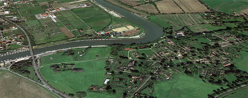
A Franco-Italian multidisciplinary team 3 decided to validate or refute the hypothesis of a harbour basin situated in the location of the trough-shaped depression sloping down towards the Tiber, between the supposed ancient lighthouse “Torre Boacciana” to the west and the so-called “Palazzo Imperiale” to the east (fig. 3), using a mechanical drill. The goal was to obtain sedimentary pieces of evidence about the ancient harbour basin of Ostia. This technology solves the problem of groundwater, which makes this area rather difficult for archaeologists to excavate beyond 2 m depth 4. In order to reach this goal two 12 m cores were drilled in this unbuilt area, which could coincide with the location of a harbour basin. The coring PO1 is located in the south of the area and PO2 in the north, near the present-day Tiber River. The stratigraphy of the two cores being similar, we will focus our discussion on PO2, which benefits from a detailed analysis in the laboratory. We will integrate this data with pollen analyses carried out on the more suitable lithologies of PO1.
The sediment cores show a complete 12 m depth stratigraphy and the evolution of the harbour zone. The deepest stratum, before the foundation of Ostia, indicates that the sea was present in that area in the early 1st millennium BC. A middle layer, rich in grey silty-clay sediments, shows a typical harbour facies. According to calculations the basin had a depth of 6.5 m at the beginning of its operation (dated between the 4th and 2d centuries BC). Previously considered as a river harbour that can only accommodate low draft boats, Ostia actually enjoyed a deep basin capable of receiving deep draft marine ships. Finally, the most recent stratum, composed of massive alluvium accumulations, shows the abandonment of the basin during the Roman imperial period. With radiocarbon dates it is possible to deduce that a succession of major Tiber flood episodes of the Tiber finally came to seal the harbour of Ostia between the 2nd century BC and the 1st quarter of the 1st century AD (and this despite possible phases of dredging). At that time the depth of the basin was less than 1 m and made any navigation impossible. It was then abandoned in favour of a new harbour complex built 3 km north of the Tiber mouth, called Portus. This alluvium layer fits with the geographer Strabo's text (see 'A harbour for Rome'), who indicated the sealing of the harbour basin by sediments of the Tiber at that time.
Regional setting
According to the Roman literary tradition, Ostia was founded in the 7th century BC during the reign of Ancus Marcius, fourth king of Rome. Titus Livius 5 wrote that the city was founded in order to make use of the salt works in lagoons. Its link with the river and the sea is however unquestionable given the etymology and the meaning of the name Ostia, deriving from the Latin noun ostium which actually means “mouth”. A couple of ancient authors claim that Ostia was already functioning as a port since its very foundation 6, but this function might have retrospectively been assigned to the city by these authors and could actually be more recent 7. From an archaeological point of view little evidence allows us to go back to such an ancient date for the foundation of Ostia. The urban nucleus of Ostia did not appear before the 4th century BC as a fortress, Castrum, made of large blocks of tufa.
During the 1st century BC Ostia played a vital role providing Rome with food supplies. This key role is illustrated in 87 BC, when Marius took over Ostia in order to deprive Rome from its supply of goods 11. While it is very difficult to find irrefutable archaeological evidence of an original Ostia dating before the 4th-3rd century BC, it is equally difficult to find tangible archaeological clues to locate a harbour at Ostia, especially during the Republican period, as well as during the Imperial one. It is likely that the harbour infrastructure (i.e. docks for loading and unloading of goods) were located along the riverbanks in direct connection with the city and the storage facilities (warehouses).
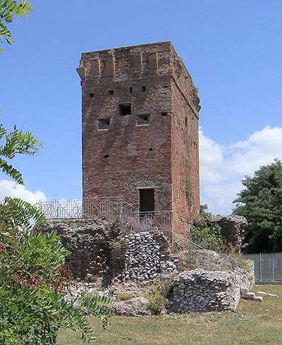
The evolution of the Tiber delta is globally well studied for the Holocene period 12. But currently only scarce pieces of information are known about the palaeo-geographical context of the Tiber mouth and its dynamics during Roman times. The coastline and the position of the Tiber channel are difficult to locate precisely around Roman Ostia. During the Republican-Imperial times the position of the Tiber mouth is without doubt in the vicinity of the “Torre Boacciana”. This structure is effectively built on an Imperial structure (probably dated to the 2nd-3rd century 13), which is the most seaward archaeological remnant we know for this period 14.
The results 15
The harbour basin is less than 600 m west of the castrum and shows no particular connections with it (fig. 6). The location should be understood as the end of an ancient itinerary, already used before the establishment of the castrum. This route, coming from the south along the beach, joined the river mouth 16. It seems to be resumed by the Via Laurentina, which is dated to the 4th century BC. The basin could be contemporary to the Via Laurentina, and possibly older than the establishment of the castrum.
The dating of the port requires making a connection with the ‘republican’ mole located in the north to the oxbow bend of Trastevere 17. Remains of this structure are still visible, but the dating is not certain. Until further research has been conducted there is no evidence that it was used during the same period.
While the environment around the basin to the north and east has been recently studied, there is very little information about the south. The exact relation between the harbour basin and the ancient remains of the “Torre Boacciana” is still to be determined. The medieval tower, located 150 m southwest from the basin, is built on a Roman nucleus. Some stamped bricks are from the 2nd century AD, but the construction clearly shows several ancient phases 18. The construction could have been used for controlling and / or signalling the river mouth. While a tower is most probable, it has no direct connections with the basin, which was at this time silted. However, there is no clue of a tower here, between the 4th and the 2nd century BC.
'Grandi horrea'
Conclusions
For the first time a multidisciplinary research combining archaeologists, historians, geographers, sedimentologists, geomorphologists, micropalaeontologists and palynologists focused on the Ostia harbour issue. The research identified the location of the river mouth harbour basin of Ostia in the north of the city, to the west of the “Palazzo Imperiale”. Coring helped highlighting a stratigraphic sequence in the depression, which was interpreted as the phase of a sedimentary filling of a harbour basin.
This study, as well as current on-going research in the laboratory and in the field, will help to advance our understanding of the relationship between Ostia, its river mouth harbour and the creation of the imperial harbours in the 1st and 2nd centuries AD. The river mouth basin of Ostia knew a widespread silting at the latest at the beginning of the 1st century AD. This element leads to two trains of thought:
(1) At the end of the first quarter of the 1st century AD, taking the tide into account, the basin had no more than a 50 cm to 1 m maximum of water column.
(2) The basin thus remained functional for boats with low draft. Ostia now had no deep harbour and the new harbour, Portus, was not yet built at this time. It can be assumed that the banks of the Tiber served as platforms, unless silting was widespread in the Tiber.
For the 1st century AD it can also be assumed that the function of the river mouth harbour of Ostia changed. Although the presence of the basin is now documented and validated by the use of coring, which allowed a palaeoenvironmental reconstruction and a chronostratigraphic study, the presence of harbour structures like a breakwater and quays, remains to be proven by archaeological excavations.
- Notes
- 1: Jean-Philippe Goiran, Elisa Pleuger and Cécile Vittori (CNRS e UMR 5133, Maison de l’Orient et de la Méditerranée, Lyon, France), Ferréol Salomon and Jean-Paul Bravard (UMR 5600, Université de Lyon, France), Ilaria Mazzini (Dipartimento di Scienze, Università Roma TRE, Italy), Giulia Boetto (Aix-Marseille Université, CNRS, Centre Camille Jullian (UMR 7299), France), Jonatan Christiansen and Pascal Arnaud (UMR 5189, Université de Lyon, France), Angelo Pellegrino (Soprintendenza Speciale per i beni Archeologici di Roma, Italy), Caterina Pepe (Dipartimento di Biologia Ambientale, Università degli Studi di Roma “La Sapienza”, Italy e Dipartimento di Scienze della Terra, Università degli studi di Roma “La Sapienza”, Italy, Laura Sadori (Dipartimento di Biologia Ambientale, Università degli Studi di Roma “La Sapienza”, Italy).
- 2: Fea 1824, 1831, 1835; Canina 1830.
- 3: CNRS, Université Lyon, Aix-Marseille Université, Ecole Française de Rome, Soprintendenza Speciale per i Beni Archeologici di Roma e Sede di Ostia, Università Roma, Università degli Studi di Roma “La Sapienza”.
- 4: Goiran and Morhange 2003; Marriner et al. 2010; Goiran et al. 2012.
- 5: Ab Urbe condita I, 33, 6-9.
- 6: Pseudo-Aurelius Victor, De Viris illustribus urbis Romae V, 3; Quintus Ennius, Annales, frag. 22.
- 7: Le Gall 1953; Zevi 2001a.
- 8: Vaglieri 1911; Coarelli 1988; Martin 1996; Brandt 2002; Zevi 2002.
- 9: Valerius Maximus, Dictorum factorumque memorabilium libri novem, III, 7-10; M. Iunianus Iustinus, Epitoma Historiarum Philippicarum, XVIII, 2, 1-2.
- 10: Titus Livius, Ab urbe condita XXII, XLV.
- 11: L. Annaeus Florus, De gestis Romanarum, III, 22; Plutarchus, Life of Marius, XLV (Le Gall 1953; Zevi 2001b).
- 12: Bellotti et al. 1994, 1995, 2007; Giraudi, 2004.
- 13: Martin 1996, p. 279.
- 14: More information about the coastline comes from the direct surroundings of Portus (Arnoldus-Huyzendveld 2005; Giraudi 2004, 2009) and from the south of the Tiber delta, on the Laurentine shore (Bicket et al. 2009). In this last publication a rapid progradation of the coastline is recorded during imperial times in the Tiber delta. This seaward progression of the coastline could have been more active at the river mouth.
- 15: The whole article, including a report of the methods and results, can be read in this PDF from the Journal of Archaeological Science.
- 16: Calza et al. 1953; Zevi 2001a.
- 17: Pellegrino et al. 1995.
- 18: Meiggs 1973.


 We are committed to providing versions of our articles and interviews in several languages, but our first language is English.