In 2017, Ahmed Fergiani wrote in an article in our magazine about the importance of the Phoenician roots of Roman seafaring in the Mediterranean and, in particular, for the ports in Sardinia1. Now, six years later, it is high time to take a closer look at those Sardinian ports, such as Nora, Turris Libisonis, Olbia, Tharros and Caralis. Today, we start with today's Port Torres either, as the Romans called this city:
Colonia Julia ad Turrem Libisonis
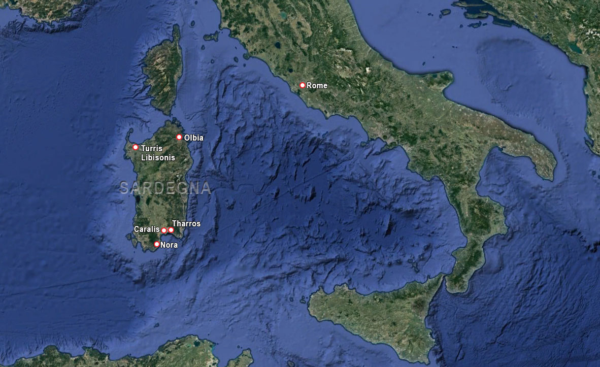
Turris Libisonis, probably founded by Julius Ceasar around 46 BC, was located in the north-west of Sardinia. It was an original Roman town and the first on the island to be given the status of Colonia Julia (colony of Julius Caesar). Pliny the Elder2 wrote in his Naturalis Historia about Sardinia:
“…..colonia autem una que vocatur ad Turrem Libisonis” (...while there is only one colony, called Turris Libisonis), by which he seems to suggest that there was no other city previously at that location3.
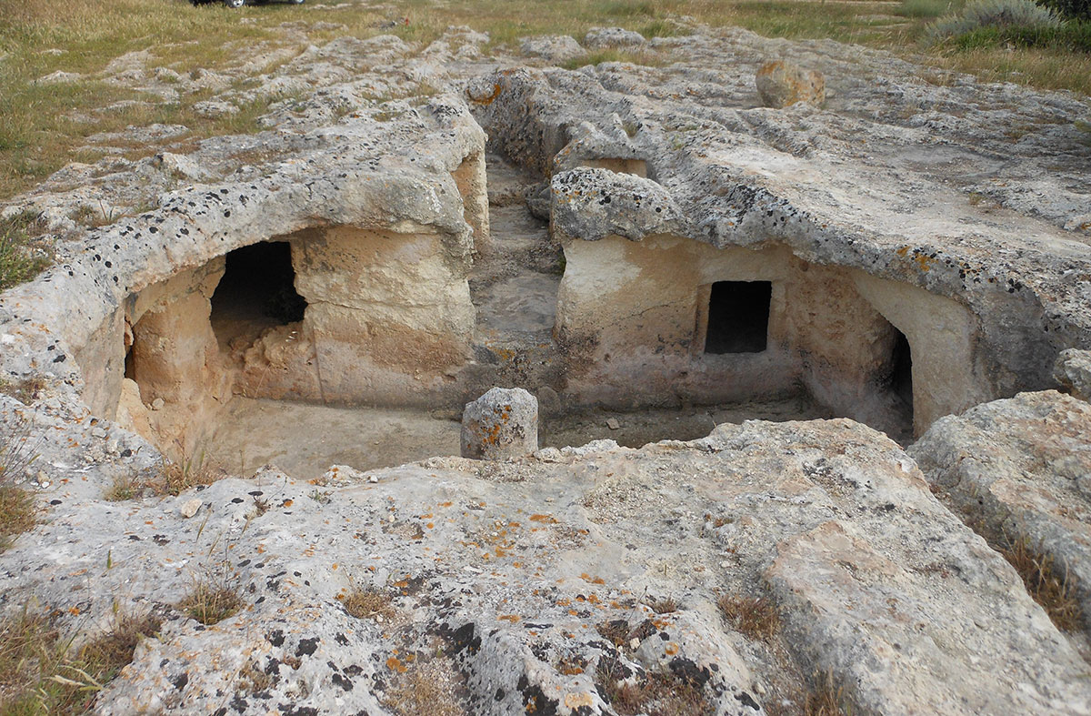
However, prehistoric cemeteries dating from 3 to 4,000 BC have been found in the area, showing that people had lived there centuries before the arrival of the Romans.
According to tradition, in the summer of 64 BC, on his way from Africa to Rome, Caesar stopped at several coastal towns in Sardinia to celebrate his triumph after the battle of Thapsus5. He probably chose the island because it offered good shelter in stormy weather for ships sailing the waterway between Corsica and Sardinia towards the Iberian peninsula. The colony, established in the Gulf of Asinara, was populated with veterans who, as Cicero mentions in one of his letters, came mostly from the Roman districts of Collina, Esquilina, Palatina and Suburana6. Renounced veterans were each given a piece of land and a town was built to live in. Turris Libisonis7 was built where the Rio Mannu flowed into the Mediterranean and was therefore suitable as a seaport as well as a river port.
Apart from the much more modest Uselis, Turris was the only other city in Sardinia where only Roman citizens lived8.
Development
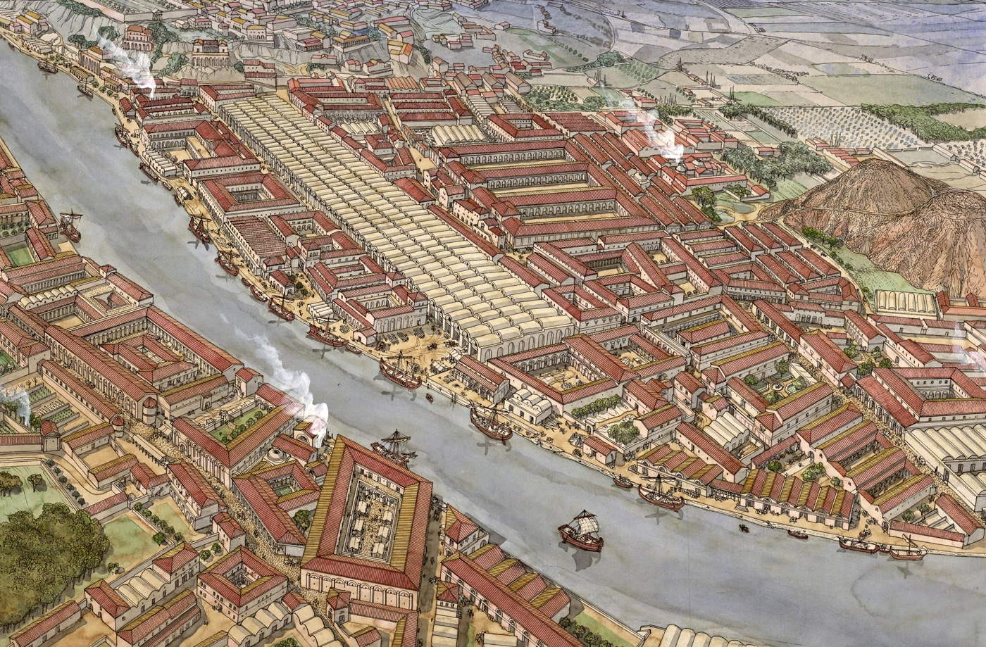
Between the end of the Republican era and the Age of Augustus, the city was equipped with an important road and port infrastructure, an aqueduct and a first bathhouse according to typically Roman urban planning and architectural principles. Archaeological excavations have revealed a regular urban layout, marked by streets (decumani and cardines) that crossed at right angles and were oriented to the wind directions.
However, hardly any traces of the earliest Roman habitation can be found in present-day Porto Torres. This is not true for the outlying areas where, especially among the later built cemeteries, traces of dwellings and warehouses built during the major expansion in the Severian period (3rd century AD) have been found.
Much about the history of Roman Turris Libisonis can be reconstructed using a multitude of literary, archaeological and epigraphic sources. Moreover, the impressive archaeological evidence has only been partially explored. The abundant epigraphic documentation provides us with information about life in the city, thanks to a series of more than 160 inscriptions, two of which are in Greek.
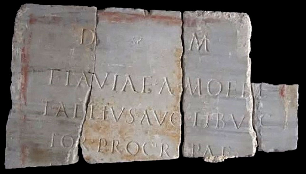
One of the inscriptions found is a plaque with the following inscription:
D(is) M(anibus)
FLAVIA F AMOEBE
T(itus) AELIVS AVG(vsti) LIB(ertvs) VIC
TOR PROC(vrator) RIPAE
A tomb inscription from the 2nd century BC for Flavia Amoebe placed by her husband Titus Aelius, an imperial freedman. Another inscription was found in the Roman harbour basin near the customs building:
PROC(vrator) RIPAE TVRR(itanae/[---] VM
P(ecunia) S(va) F(ecit)M
This second inscription refers to an (unnamed) official from the wealthy bourgeoisie who was in charge of controlling shipping traffic and collecting customs duties. The two inscriptions both mention the function of the two protagonists (procurator Ripae11) and clearly show that the intensive trade of the colony required a precise organisation of port activities over which an imperial official with the title of ‘Procurator ripae Turritanae’ exercised control. This official had administrative powers over the port of Turris, probably originally at the mouth of the Rio Mannu and later extended to the seaport area on the north side of the city.
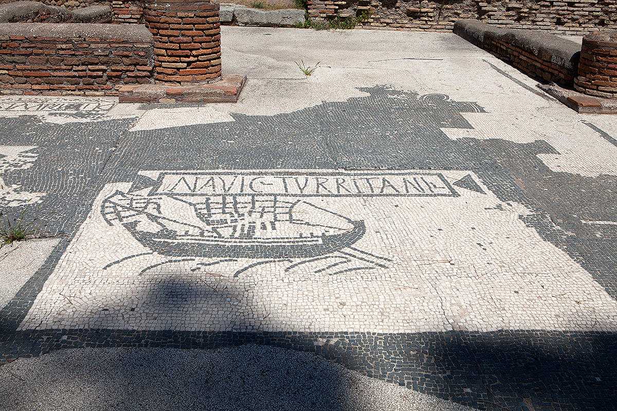
That there were close links with Rome is shown by the famous mosaic of black and white tesserae12 discovered in the square of the Corporations in Ostia, dating from the late 1st century AD, which depicts an oneraria ship13 with unfolded sails and double rudder, with an inscription above it recalling the navic(ularii), transport entrepreneurs and owners of a permanent agency in Ostia, similar to those of other maritime cities.
But above all, Sardinia was considered one of the granaries for Rome. Grain was transported in large canvas sacks and placed in warehouses, called horrea awaiting export. It seems that granite from Gallura, live horses and pork were also exported.
During the 2nd century AD, Turris Libisonis traded with Gaul in wine and in the 3rd century AD in oil with Baetica.
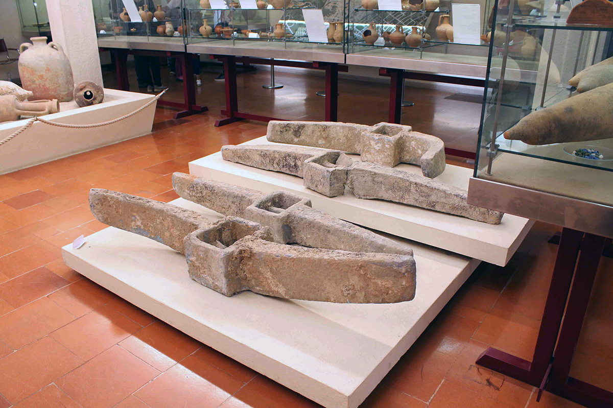
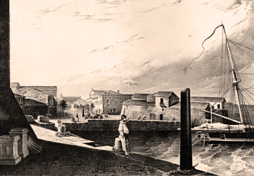
Some wrecks and several anchor stumps and lead anchors found a short distance from the mouth of the Rio Mannu testify to the existence of intensive ship traffic in the Gulf of Asinara, also related to fishing and small commercial shipping.
At the height of its development, between the end of the 2nd and 3rd centuries AD, the above port flourished even more thanks to maritime trade, grain and livestock economy, fishing, mining and craft activities.
The movement of the harbour basin, which took place in the Severian era (late 2nd - early 3rd century AD), would correspond to a new urban planning programme, with the centre expanding eastwards, and the forum south of the present dock and near the warehouses (horrea).
During the 4th century AD, Turris Libisonis remained the main port of northern Sardinia and was still part of the routes covering Africa and the Italian peninsula, as well as the northern markets, via the port of Marseille, Narbonne and those of the Iberian peninsula, from whence came garum, the famous and widely used fish sauce that was abundant in the cuisine of the wealthy Romans.
Immigrants from Ostia in Turris
Only of a few persons mentioned in Turris Libisonis we know their native region or city. In contrast, relatively many surnames, especially after the Severian period (3rd century AD), refer to the port city of Ostia.
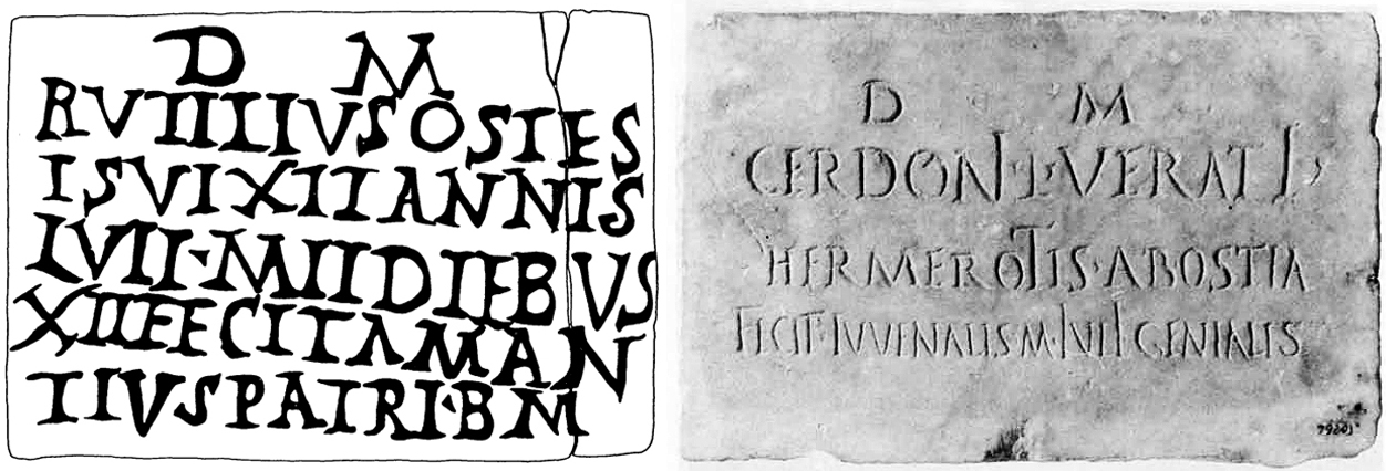
Figure 7: Drawing of tomb inscription Figure 8: Tomb inscription
Numerous other examples could be given. It is clear, then, that important citizens of Ostia did business in the port of Turris and in the fertile hinterland, which was irrigated by the Rio Mannu, and which was used for intensive grain cultivation, destined for the grain supply of the capital Rome (Sardinia, together with Sicily and Africa, was already considered in Cicero's time as one of the tria frumentaria subsidia rei publicae, one of the sources of grain supply for the public annona15).
Turris Libisonis is one of the Sardinian towns that, in Roman times, seems mainly connected to the countryside and acted as a gathering place for products destined to be marketed outside the island.
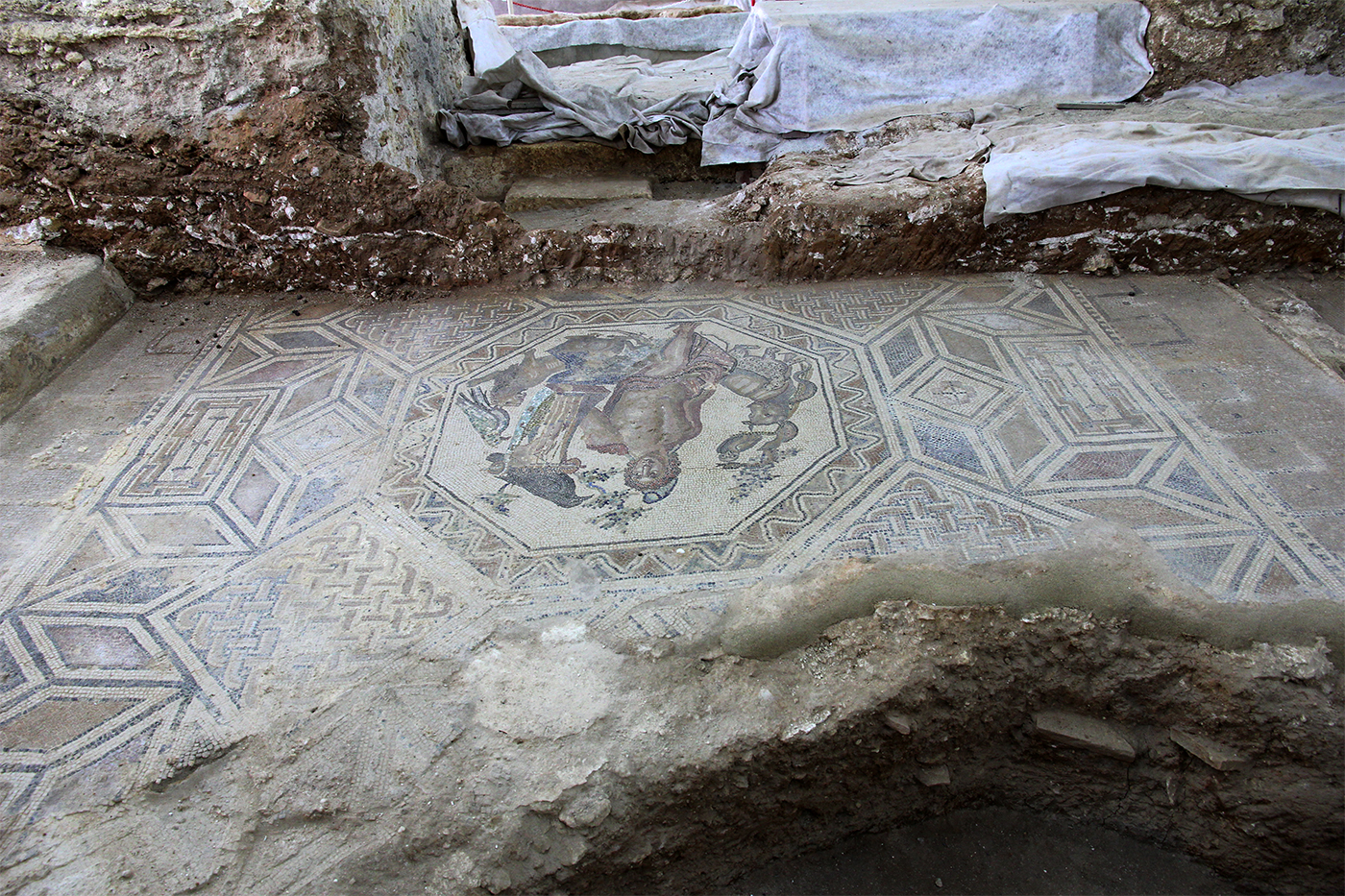
Somehow, it is also linked to the development of Mediterranean trade, which could make use of the port at the mouth of the Rio Mannu. The sparse urbanisation of northern Sardinia promoted the development of a latifund economy (large-scale farming, worked by slaves) based on grain monoculture, which required the employment of numerous servants. Consequently, numerous farms and rustic agglomerations appeared around the city. Some of these villas, spacious and equipped with a bathhouse have emerged during excavations. Some with beautiful mosaics.
The hills were probably used for animal husbandry including pigs for the, in the late third century AD, documented export of caro porcina (salted pork).
The same can be said of the ships that followed the route of the Balearic Islands and the Strait of Bonifacio to Ostia from the Iberian peninsula.
The Sardinian and African grain was then stored in the great horrea of Ostia and Rome, to be used throughout the year.

The river played an important role in the economic development of the western area, as a connecting route to the hinterland from where metal and grain products were brought in.
The bridge over the Rio Mannu was one of the first infrastructures built, connecting Turris with the road to the Nurra18.
The bridge is about 135 metres long, about 8 metres wide and consists of 7 unequal arches sloping from west to east. The piers have spurs for refraction of the water flow and to protect the structure. The middle pylon has none.
Recent research in the riverbed has discovered a structure about 18 metres long and 2 metres high at a depth of 50 cm. Perhaps we should think of an artificial bank or mooring wall here.
During excavations in 1965, paving was already found under the last 4 eastern arches.
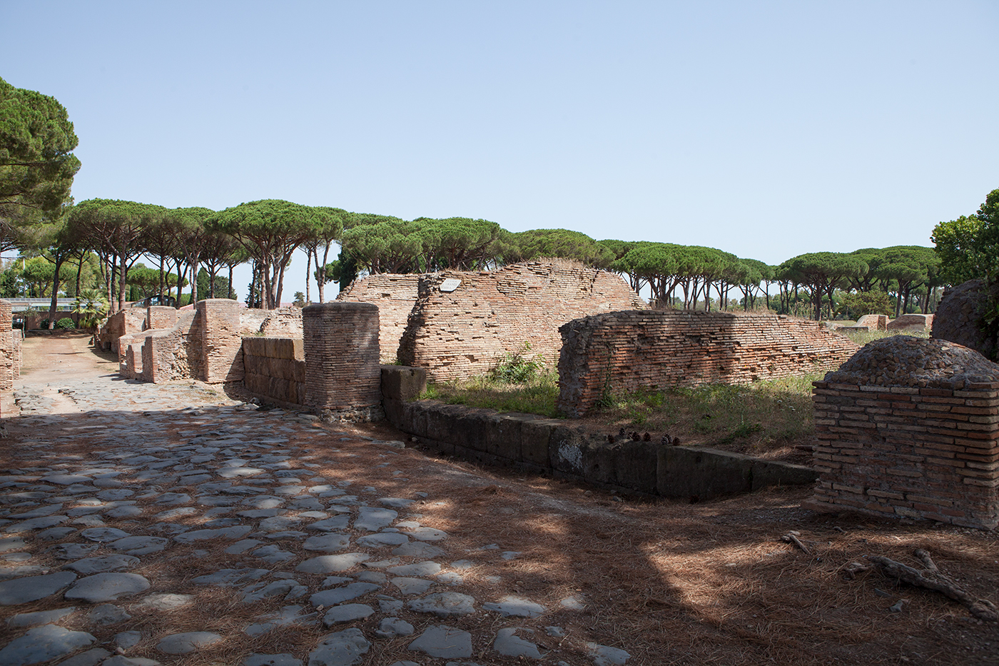
Excavations in the old town
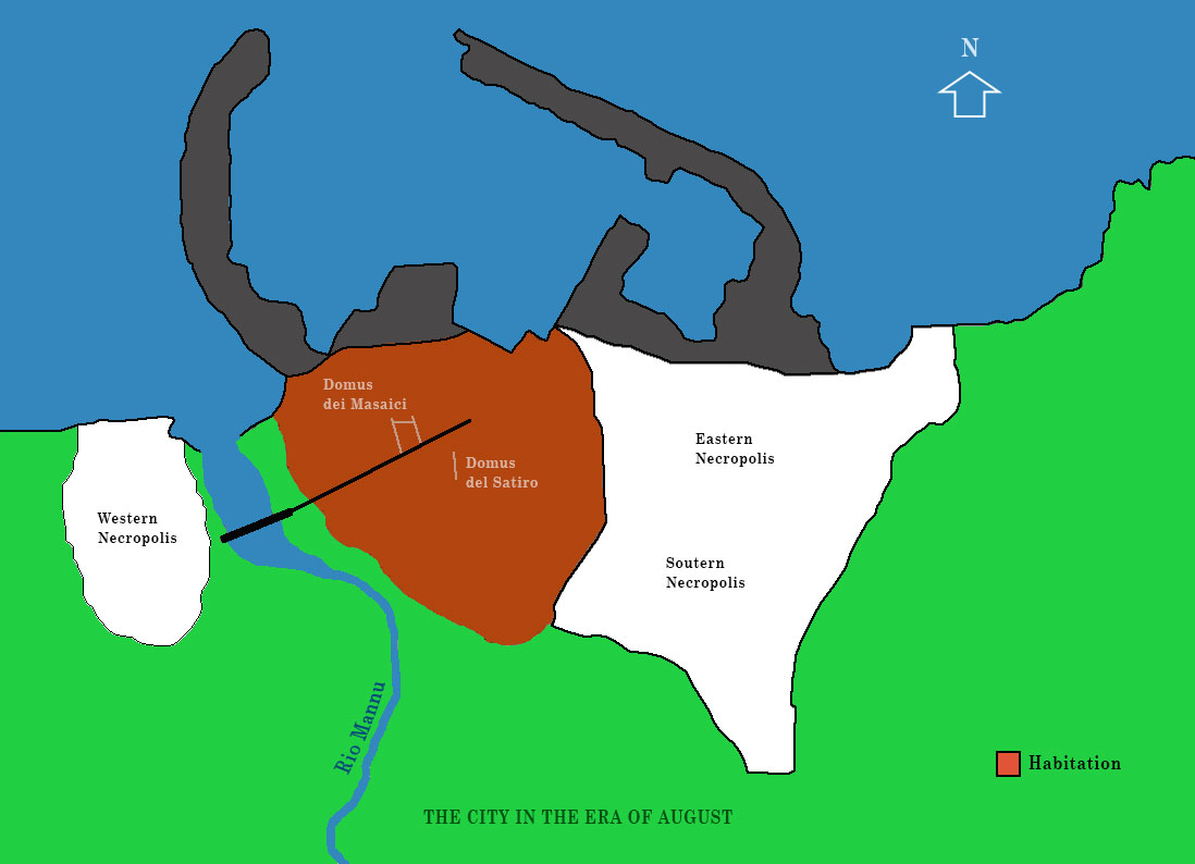
Between the 1st and 2nd centuries AD, we see much building activity in the area east of the Rio Mannu, at the entrance to the city via the bridge over that river and in the south-eastern suburb. Originally there were probably necropolises in those southeastern areas (see Figure 3). There seems to have been new town planning, with new road axes connecting the very first town layout with the eastern extensions.
Between the end of the 2nd and 3rd centuries, a wall was built to the west, partly parallel to the course of the river.
During construction work for a new port in 2006, and especially through the demolition of the lighthouse pier, several Roman structures emerged, often built with limestone ashlar blocks (rough stones processed into square blocks), lime, mortar and trachyte slabs.
Among the remains of the constructions, they found many bronze coins, fragments of transport amphorae, parts of columns, ceramics and marble epigraphs from the Roman period. Furthermore, along with the remains of monumental buildings, huge stone arch structures, marble wall linings, capitals, columns and three fragmentary headless statues were found.
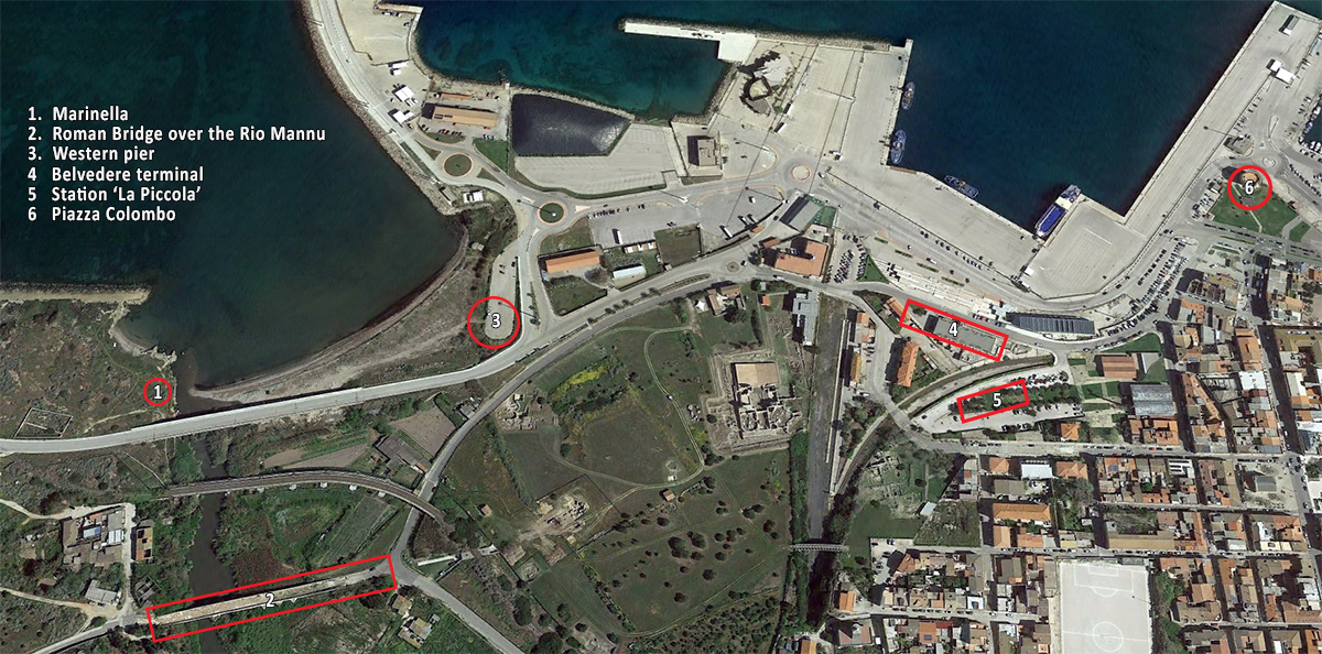
Marinella
In 1964, excavations took place north of the bridge over the Rio Mannu, at the Marinella site (see Figure 13.1). On a hilltop near the riverbank, casts for the manufacture of oil lamps that can be dated between the end of the 1st century AD and the end of the 2nd century AD were found. Apparently, this area was intended for artisanal production.
The Westpier
Near the West Pier (Figure 13.3), two wells connected to a freshwater distribution system were found in 2009. The archaeological material is of particular interest as it can be placed in the chronological time frame between the late 2nd century BC and the 1st century AD.
Maritime Station – La Piccola
In the area known as 'La Piccola' (Figure 13.5), three road axes form an intersection and indicate urban restructuring between the late 2nd and early 3rd centuries AD, probably by design from the second half of the first century BC. One of these roads gave access to the old harbour. Next to the roads were monumental fountains and public and private buildings. In the eastern sector, structures in opus isodomum21 had phases of reuse until poor graves were placed on top of them in the 7th century.
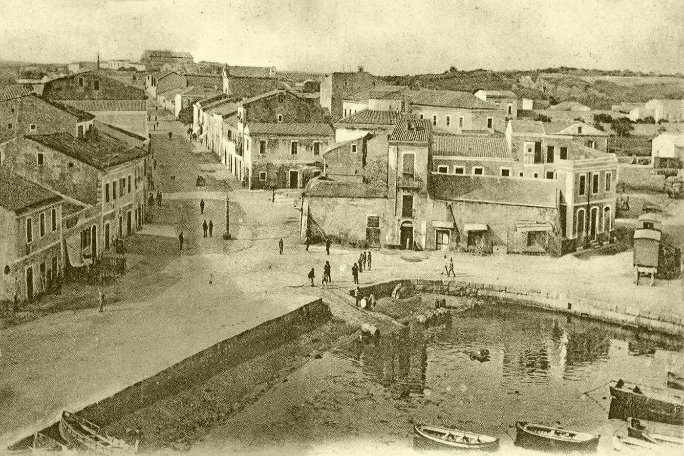
Maritiem station – Belvedere (figure 13.4)
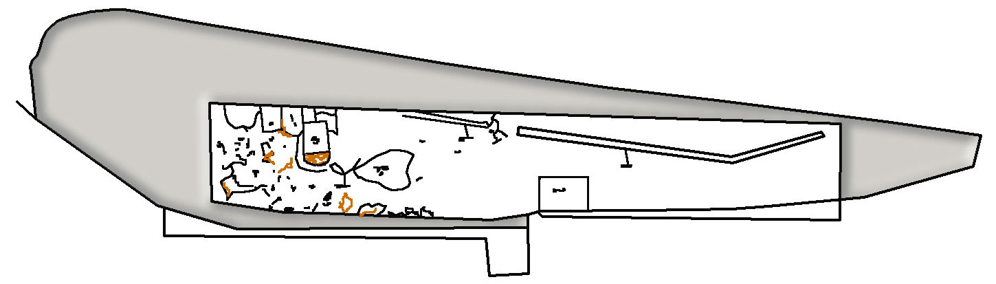
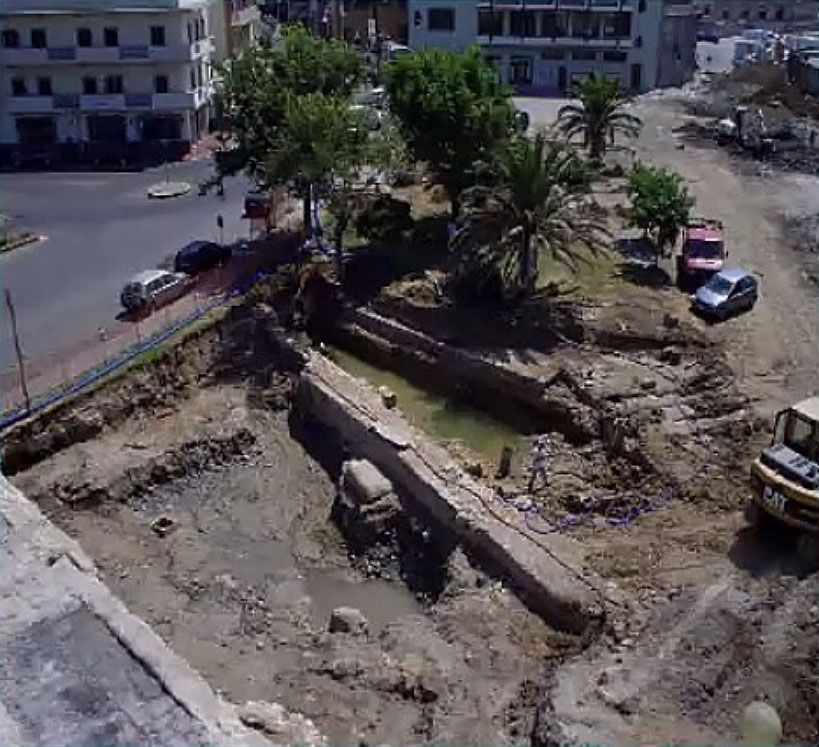
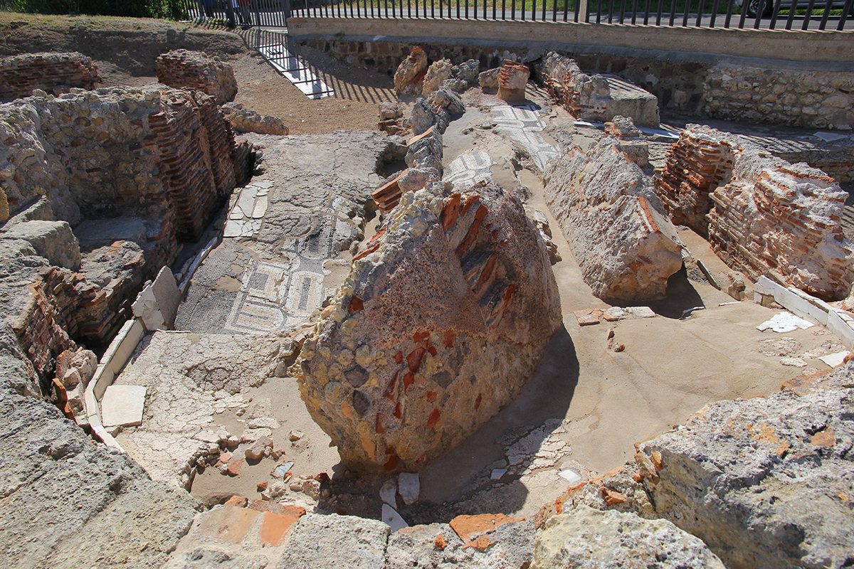
At this site, it was noticed that the location of the Roman harbour was not so different from that of the current harbour. Here, between the 19th century and the early 20th century, port works were carried out including the construction of a limestone dock. That dock covered archaeological layers from the Imperial period (figure 16). These Roman layers included foundations of rooms that could be heated and some of which were covered with polychrome mosaic floors and geometric decorations.
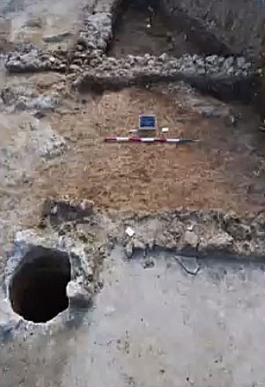
In the summer of 2010, prior to the construction of a new port terminal to link Maritime Station 'La Piccola' with the Belvedere, new excavation research was first carried out on site. First of all, the area had to be cleared of accumulations of dirt and sloppy and chaotic previous excavations, which had disturbed or destroyed large parts of the underlying and adjacent archaeological structures and stratigraphic traces. Construction activities since the late 19th century have also seriously affected the archaeological context originally characteristic of the site, close to the shoreline adjacent to the harbour basin. This fact, together with a continuous and unstoppable rise of the water, made the investigation very complex.
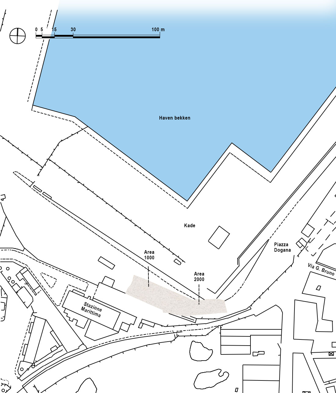
The survey was organised into two areas, area 1000 (western sector), and area 2000 (eastern sector), both characterised by the presence of ancient structures.
In area 1000, the already mentioned parts of the building with several rooms built in opus pseudo-isodomum23, were exposed again.
In area 2000, on the east side, the modern damage was deeper and more extensive, obliterating almost all ancient remains from the Roman period. Here, only a few stratigraphic traces and part of a roadway, of which isolated paving stones lay in a non-original position, were preserved.
The whole area shows a further urban extension of the ancient Roman city, with parts of structures diverse in form and function. Some can be attributed to monumental buildings. These were sometimes of a public nature and still others were used for productions. Based on their numerous technical and functional features, several were intended for port facilities.
Port infrastructure from the second half of the 2nd century and the 3rd century AD were used as civilian dwellings in the subsequent phase, with their essential structural components reused, stripped of the wall and floor coverings with which they had been equipped in the first phase.
Finally, former buildings that had long ceased to have a function and had already been partially dismantled during the 5th and 6th centuries AD were used as a new sector of the necropolis. Numerous artefacts that can be traced to both products from local workshops and imported ones were also found during this investigation in the various earth layers and graves: tableware made of African Sigillata, ceramics, coins, gold and decorative grave goods made of terracotta and Italian terra sigillata24, as remnants of the earliest use of the area.
The discovery of two pieces of traffic vein are also of particular interest. They complement the developments of the well-known ancient road network dating back to the late 2nd -3rd century AD.
In Piazza Colombo (figure 13.6), excavations deep under the building used as the harbourmaster's headquarters they found part of an ancient block-built quay wall of the ancient Darsena26, which certainly dates from Roman times. The associated stratigraphy dates it between the late 2nd and 6th centuries AD. On Corso Vittorio Emanuele, near the port, excavations in the 1970s found the remains of the walls of the horrea built in the 3rd century AD, which were destroyed by the construction of the Vandal-era wall.
In Piazza del Comune, a short distance from the horrea and the port, the forum can be identified at the meeting point of the cardo (last stretch of the road that connected Cagliari to Turis) and the decumanus coming from the bridge that crosses the waters of the Mannu River at the edge of the city.
SIGHTSEEINGS OF THE ROMAN CITY
Although inscriptions speak of remarkable monuments, few of them have been identified so far: a temple of the goddess Fortuna, a basilica with a courtyard decorated with six columns, which was apparently restored in the 3rd century AD and a reserve tank for water built at the expense of a magistrate of the colony.
From the archival records, we can also infer the existence of a building for spectacles on the north side of one of the hills overlooking the coastline at a short distance from the forum: a theatre or amphitheatre.
The only traces of the aqueduct are fragments found not long ago and various names recalling the aqueduct along the ancient route (parallel to today's SS 131) along which water was brought to the Roman colony.
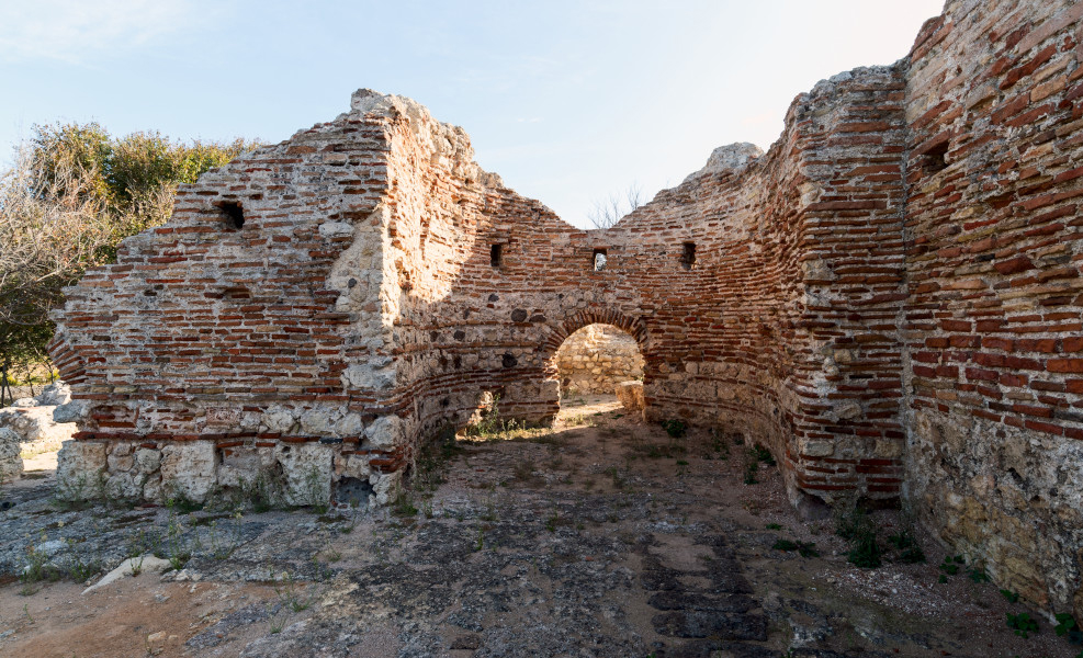
During the early imperial era, housing was created in an area that was later reused by several thermal baths: the Central Baths, the Maetzke Baths and the Pallottino Baths, which were uncovered between 1940 and 1960. A water collection basin was also built to provide the main spa facilities.
The Central Baths
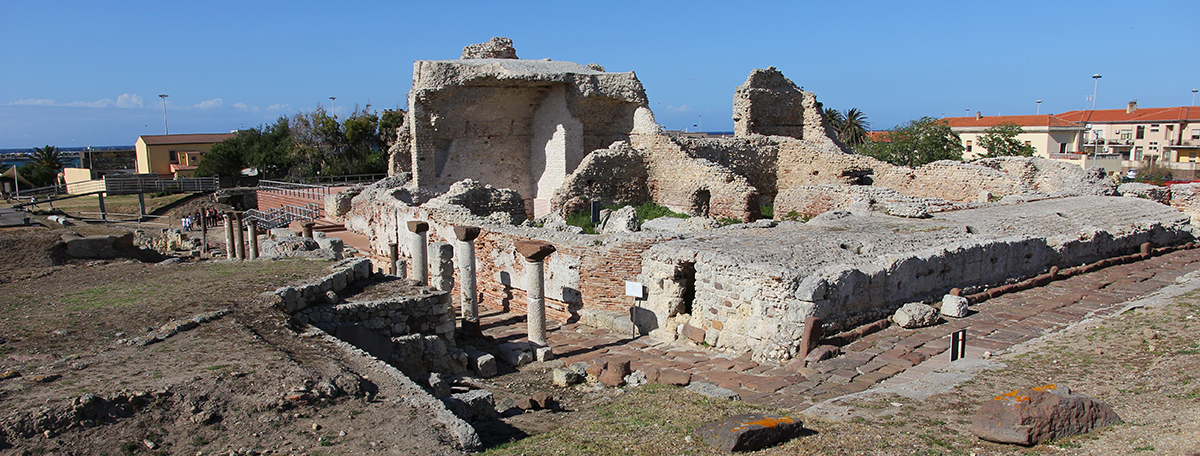
The baths have a rectangular layout, consisting of eight rooms, bordered by a portal and an older cryptoporticus, with walls in opus vittata, i.e. with the elegant alternation of bricks and blocks of tuff, limestone, as well as bricks mixed with large tiles, while the foundation consists of limestone blocks.
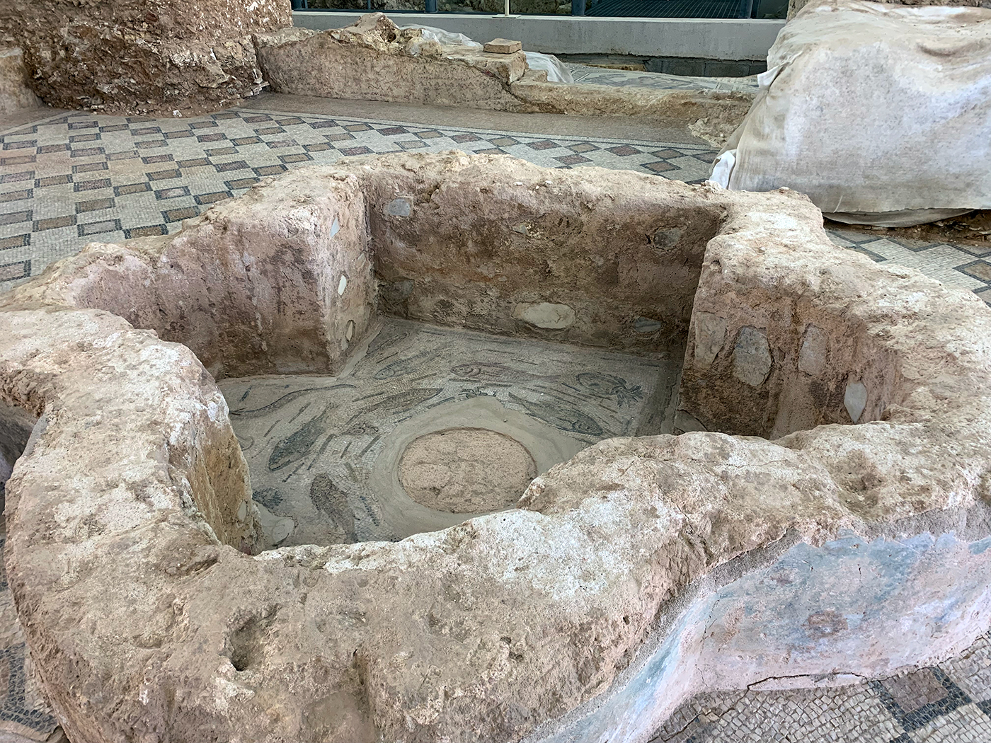
Access to the north-facing baths was preceded by a staircase leading to a rectangular portico, followed by the frigidarium (the room for cold baths). This was equipped with two basins with mosaic floors, an apodyterium (dressing room) and the tepidarium (room with lukewarm baths), from which one could proceed to the three calidaria (room for hot baths). The complex dates from the late third century AD and early fourth century.
Excavations carried out in the south-east sector of the baths from the 3rd century showed that the entire thermal complex was partly developed on an embankment, on top of another bathhouse dating from the 2nd century below it, which in turn was built on top of an even older complex from the 1st century.
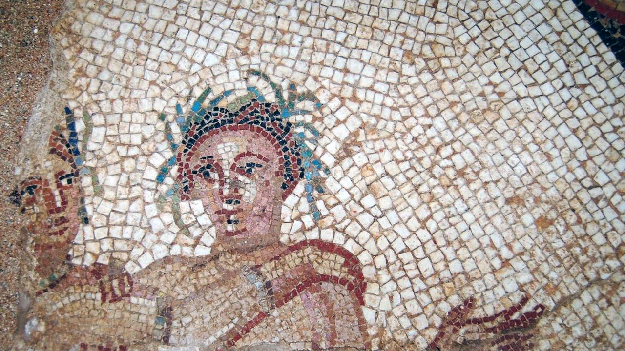
Connected to the central complex, an impressive presence of mosaics was found. These too date from the late 3rd and early 4th centuries AD. They were part of a vast area dedicated to buildings for public use.
Baths of Maetzke
They derive their name from their finder and form the easternmost part of the thermal complex.
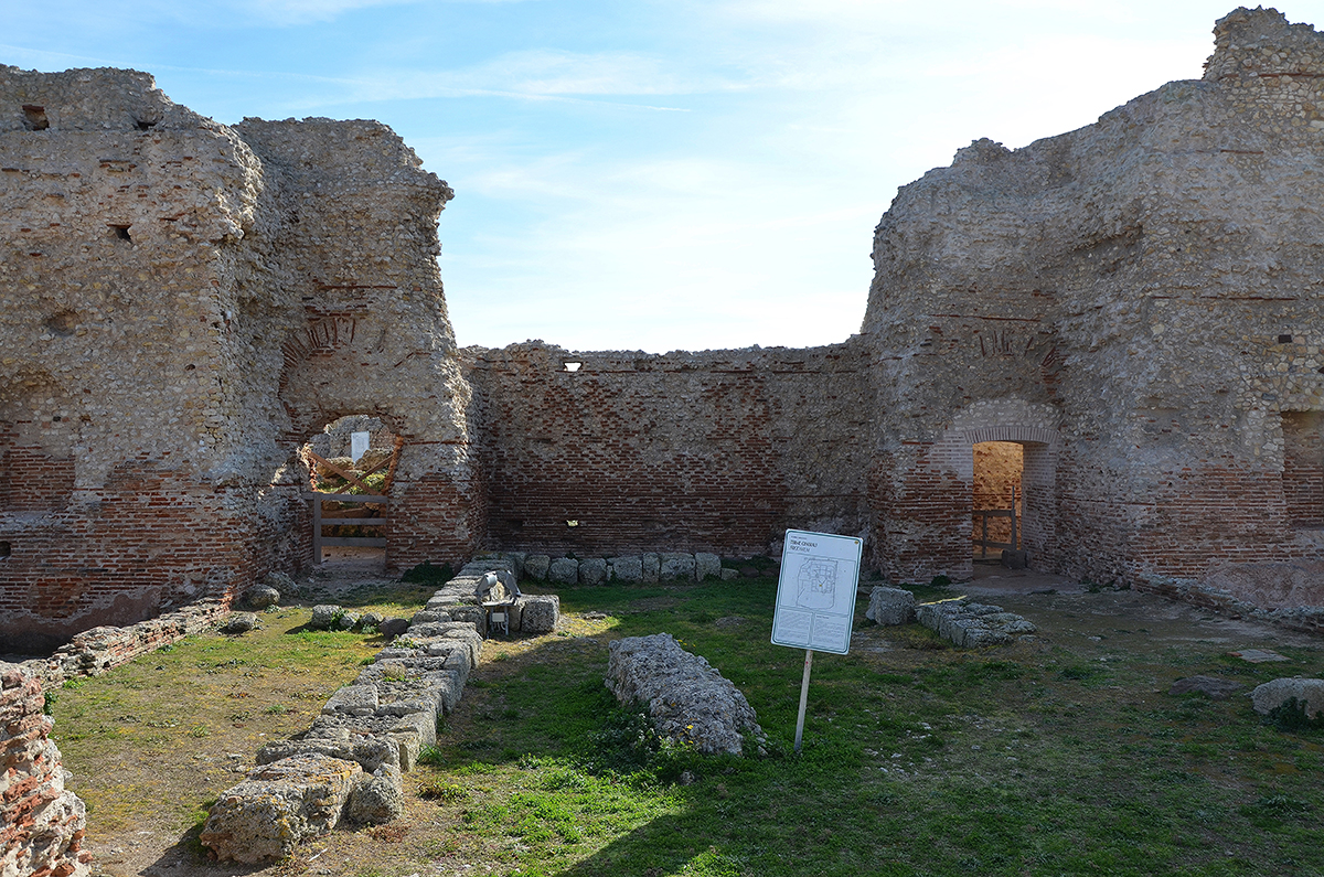
The Pallottino bathhouse
About this bathhouse, the Museo Archeologico Nazionale Antiqarium Turritano e Area Archeologica reports: "This small thermal complex was excavated in the 1930s by archaeologist Doro Levi, director of the Superintendency of Sardinia until he was removed from his post as a Jew in 1938 in application of fascist racial laws. He was then replaced by archaeologist Massimo Pallottino, after whom the baths and the nearby peristylum (covered portico) were named.
Of the baths, which were also public, the three chambers of the 'caldarium', 'tepidarium' and 'frigidarium' have been preserved; here, three steps led to a quadrangular mosaic pool that is still well preserved. The complex is dated, based on the mosaics decorating the floors, between the late 3rd and early 4th centuries AD.
In the 'tepidarium' the remains of the collapse of part of the walls and vaults, which severely damaged the floor, can still be seen. Part of the walls have only been rebuilt in recent years. The undulating pattern of the floor is due to the presence of 'sospensurae' (piled stones that raised the floor through which hot air heated the rooms).
Excavations in recent years have uncovered a series of structures behind the 'caldarium' that were probably related to water supply and heating.
Between the 'Antiquarium Turritano' (Archaeological Museum of Porto Torres) and the Central baths, remains of habitation have been found; insulae (residential blocks) and tabernae (shops). Some of these can be seen in the museum. The buildings are enclosed by streets paved with vulcanite slabs.
- Sources
- - www.romanoimpero.com/2014/02/turris-libisonis-sardegna.html
- - Tito Livio – Ab Urbe condita libri
- - Attilio Mastino, Cinzia Vismara - Turris Libisonis – 1944
- - Arrilo Mastino, Popolazione e classi sociali a Turris Libisonis i legami con Ostia 1984
- - Attilio Mastino, Turris Libisonos in età romana - 1992
- - Ettore Pais, A. Mastino - Storia della Sardegna e della Corsica in età romana - Iusso - 2000
- - Gabriella Gasperetti - Resti di infrastruttue portuali della Colonia Iulia Turris Libisonis (Porto Torres) 2021
- - Antonella Pandolfi, Daniela Deriu, Luca Angius – Terminal Portuale 2010
- - Antoni etta Boninu, Antonella Pandolfi – Porto Torres Colonia Iulia Turris Libisonis, archeologia Urbana 2011
- - Wikipedia
notes- 1: See article ‘Imitatio et Aemulatio’
- 2: Gaius Plinius Secundus maior (23 – 79 AD.), Roman soldier, linguist, amateur scientist, historian and natural philosopher.
- 3: Plin. Nat. III.13
- 4: Photo Wikipedia (Gianni Careddu)
- 5: Battle during the Roman civil war (49-45 BC) between Julius Caesar and Pompey.
- 6: Rome's four oldest districts officially named by Rome's sixth king, Servius Tullius.
- 7: Turrem Libysonis: the first part is the mv. of 'tower' and probably refers to prehistoric towers that stood there; the second part refers to Lybia, the former name of the African north coast, with which the island had a relationship in the past.
- 8: Plin. Nat. III,85
- 9: Photo – after drawing from Gabriella Gasperetti's lecture.
- 10: Photo from lecture Gabriella Gasperetti.
- 11: Literally: 'Driver of the shore'.
- 12: Small square pebbles.
- 13: Roman cargo ship (from the Latin word 'onus' meaning, among other things, cargo)
- 14: See article 'Overseas-trade.'
- 15: The annona was the imperial service responsible for overseeing the supply of important foodstuffs to the city of Rome and the army. The service was mainly concerned with grain, but became increasingly involved in the supply of other products, such as olive oil, wine and pork. By the end of the 3rd century, the annona was a complex machinery with private and public agents in different parts of the empire.
- 16: Photo Gianni Careddu (Wikipedia)
- 17: Drawing Jean-Claude Golvin.
- 18: Land west of Turris.
- 19: Photo Wikipedia - Daniel Cualbu
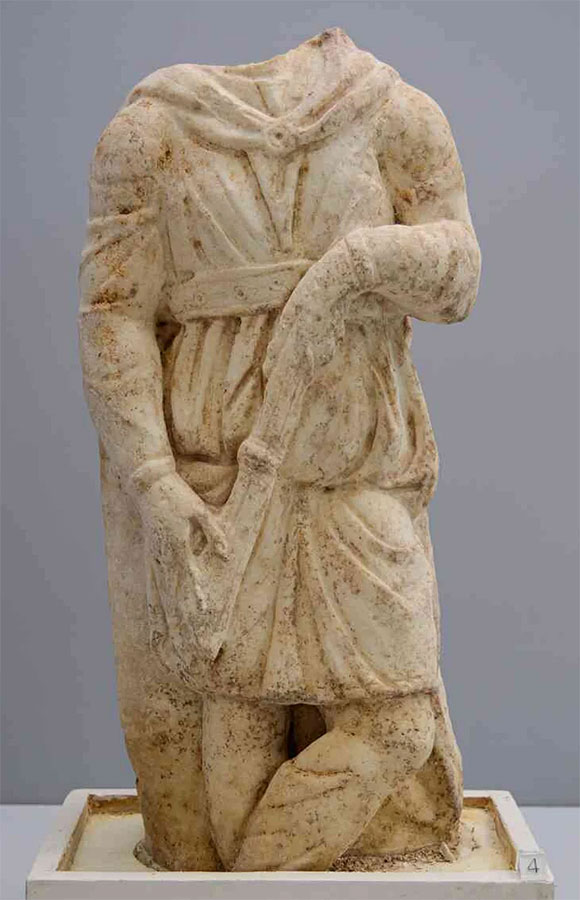
- 20: Statue of Cautopates, one of the helpers of the Persian sun god Mithras who was particularly popular with Roman soldiers. Statue from the third century AD found in the Central bathhouse at Turris Libisonis - Photo: Museo Archeologico Nazionale Antiquarium Turritano e Area Archeologica.
- 21: Built with Ashlar blocks of the same height.
- 22: Photo: From article Gasperetti (Sassari 1979) 2nd century AD.
- 23: Opus pseudo-isodomum - masonry square blocks of equal height but of variable length.
- 24: Terra sigillata – (Latin) stamped pottery
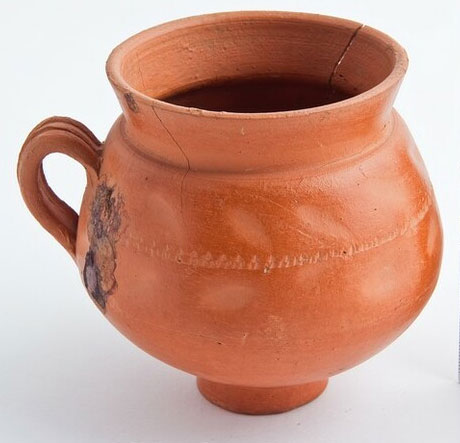
- 25: Jug from Porto Torres (2nd-3rd century AD) - Museo Nazionale Antiquarium Turritano
- 26: Repair port and dock.
- 27: Photo – Gianni Careddu (Wiki)
- 28: Photo – Carole Raddato
- 29: Photo - Ministero della Cultura
- 30: Photo – Gianni Careddu (Wiki)
- 31: Photo – lanuovasardegna.it
- 32: Photo2023 (Wiki)


 We are committed to providing versions of our articles and interviews in several languages, but our first language is English.