“Now upon his observation of a place near the sea, which was very proper for containing a city, and was before called Strato’s tower, he set about getting a plan for a magnificent city there; and erected many edifices with great diligence all over it: and this of white stone. He also adorned it with most sumptuous palaces, and large edifices for containing the people; and what was the greatest and most laborious work of all, he adorned it with a haven, that was always free from the waves of the sea” 1.
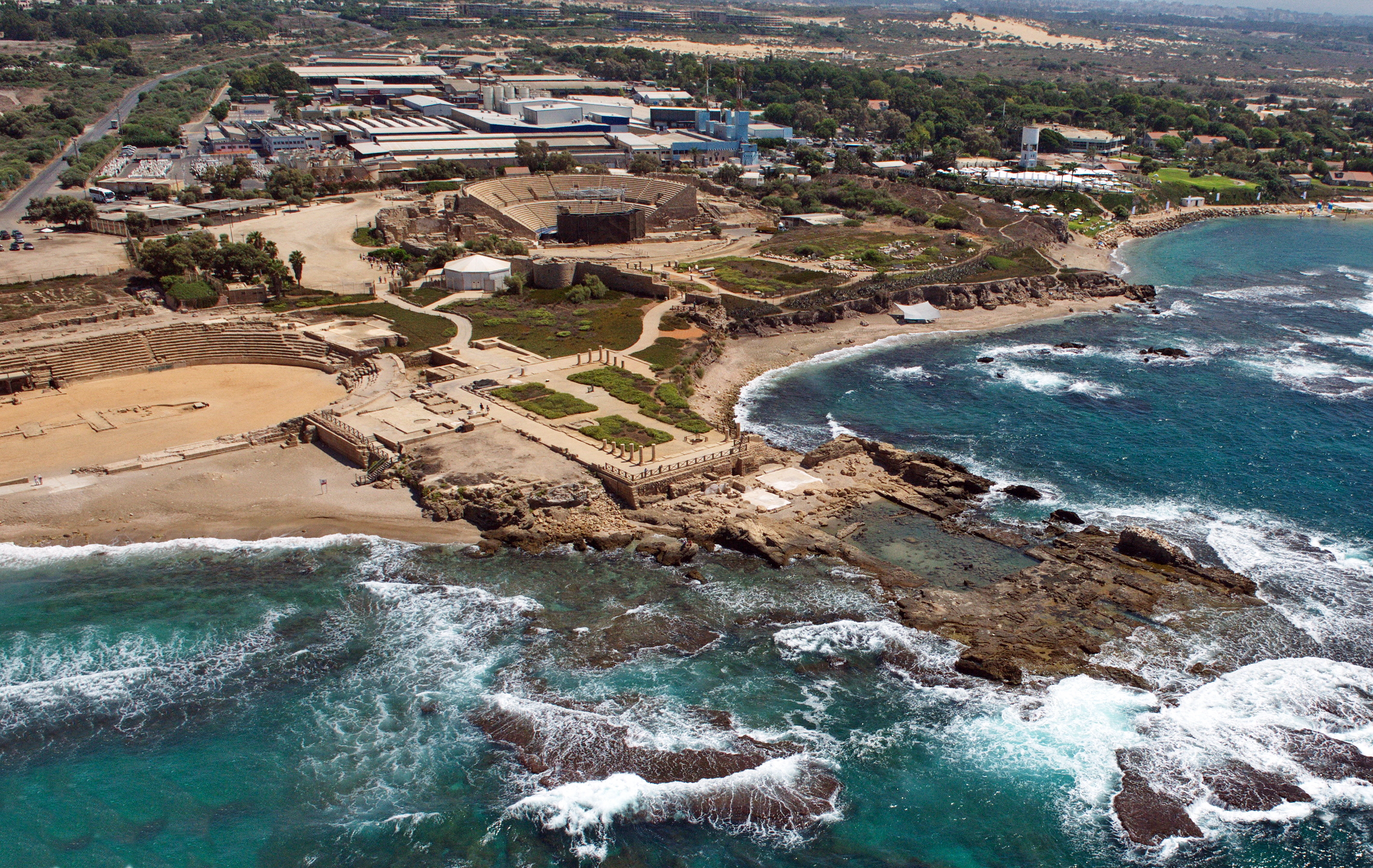
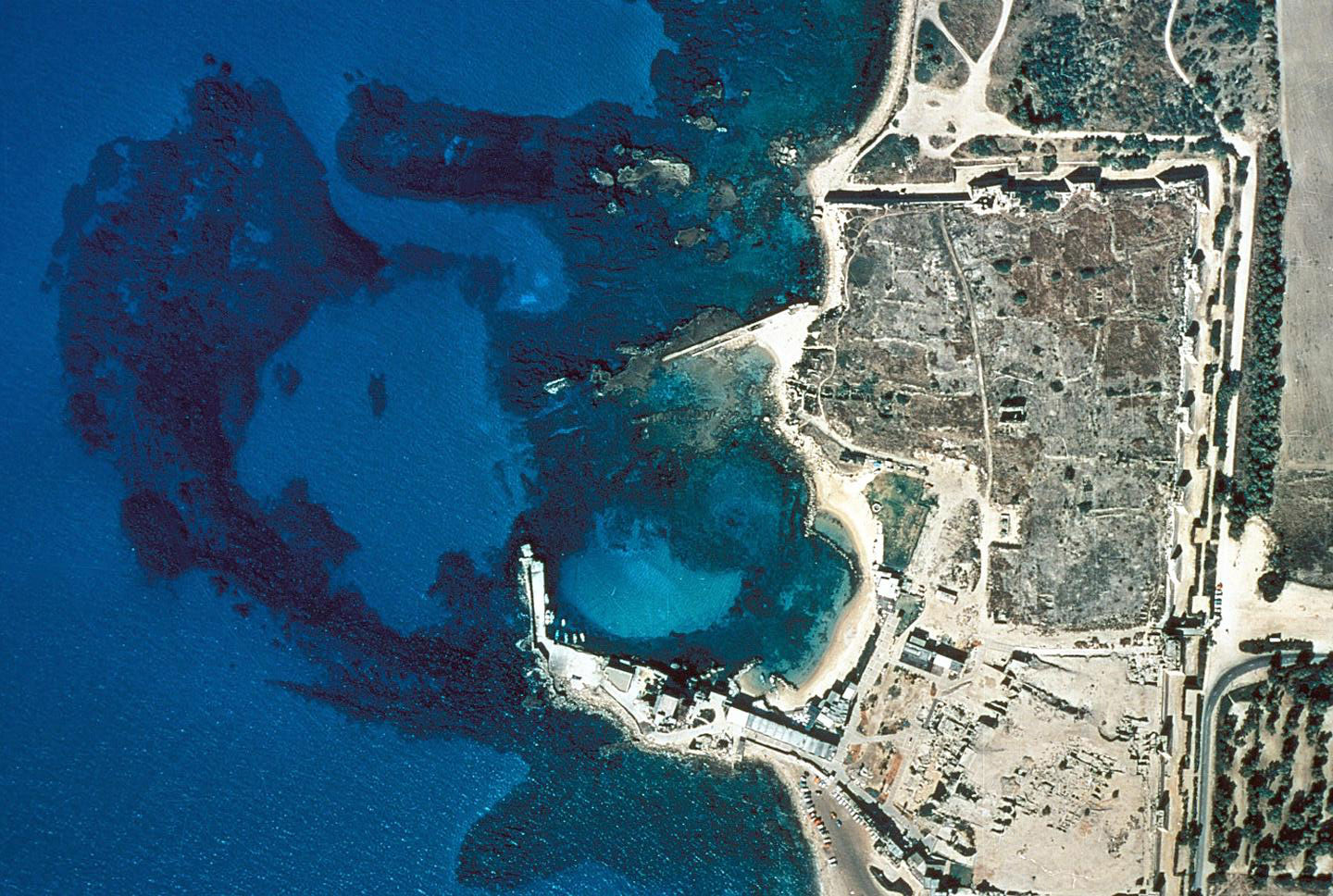
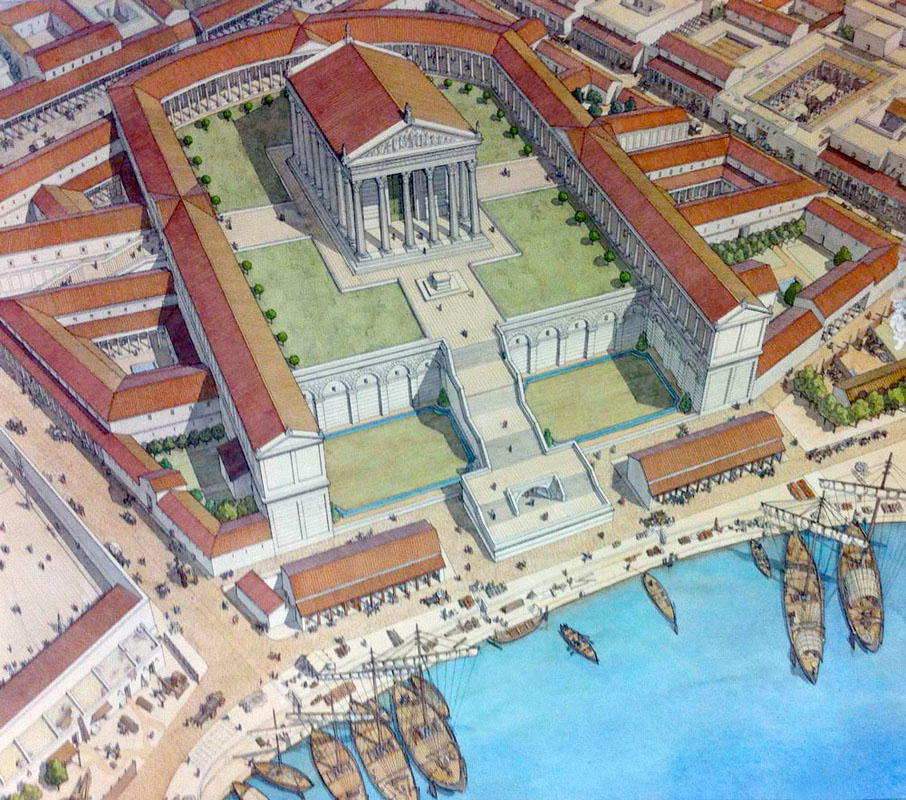
On a coastal plain in north-central Israel, between Tel Aviv and Haifa, the famous port city Caesarea Maritima was built between 20 and 10 BC. Near the ruins of a small Phoenician naval port known as Stratonos Pyrgos (Straton’s Tower) 2 king Herod the Great, who owned a palace looking out over sea, built this port. Judea was occupied by the Romans in that time and Herod named his new city in honour of his patron Octavian Caesar Augustus: Caesarea, in Greek Sebastos (the Greek equivalent of Augustus). In 6 AD Judea was converted into a Roman province and the governmental residence and military headquarters were moved from Jerusalem to Caesarea. According to Flavius Josephus 3, the outbreak of the Jewish revolt of 66 AD was provoked by Greeks of a certain merchant house in Caesarea, sacrificing birds in front of a local synagogue. In 70 AD, after the Jewish revolt was suppressed, games were held here to celebrate the victory of Titus. Many Jewish captives were brought to Caesarea Maritima. Kasher claims that 2,500 captives were "slaughtered in gladiatorial games" 4. After the destruction of Jerusalem in 70 AD, Caesarea became the provincial capital of the Judea Province. Every five years the city hosted major sports competitions, gladiator games, and theatrical productions in its theatre overlooking the Mediterranean Sea.
Sebastos
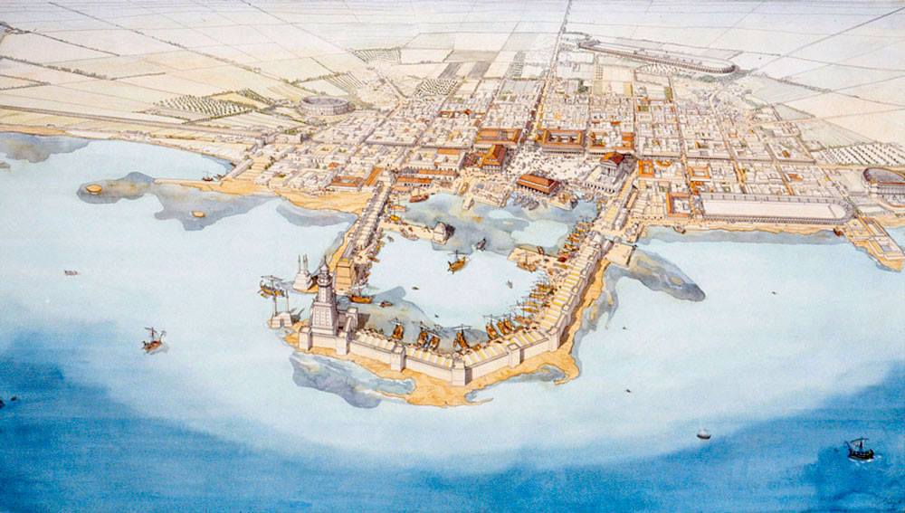
In 22 BC king Herod began the construction of the largest artificial deep sea harbour in open sea and built storerooms, markets, wide roads, baths, temples to Rome and Augustus, and imposing public buildings, enclosing around 100,000 m2. When it was finished in 15 BC he named the harbour after Caesar. The pace of construction was impressive considering size and complexity. The location of this harbour was not ideal. The coastline is straight without natural protection against wind and waves. The current of the sea is very strong and brings a lot of sediment from the river Nile, filling every possible creek. To avoid these problems Herod built two breakwaters made of underwater concrete by using lime and pozzolana, a volcanic ash imported from Pozzuoli (read also ‘Pompeiopolis, Roman port in Turkey’).
There is much doubt about the function of Herod’s harbour. Was it only a commercial harbour or also a military one? Josephus wrote that the intention was to build a harbour for receiving large armadas. Probably Sebastos was meant to shelter fleets on their way from Alexandria to Rome against storms and other dangers 6. However, some structures have been found pointing to a military harbour as well. Three rectangular, parallel structures made of ashlar 7 with an outlet to the middle of the main basin of the harbour are seen as possible boathouses. Four vaulted rooms, alongside the stairs at the west side of the so-called Temple platform, are interpreted as 3rd century horrea (storehouses). All four do not have a closing wall at their west side, so here too one can consider that we are dealing with boathouses 8. Others, like Blackman & Rankov9, however have doubts about that. Maybe a wooden construction was used as a slipway between the rooms and the basin. On the other hand, the sizes of these rooms are too small to house biremes (warship with two rows of oars) and may possibly have been used for small galleys. Finally no hard evidence, whether historically or archaeologically, has been found of the real commercial or military nature of the port of Sebastos 10.
The construction of the harbour
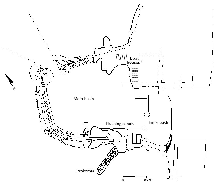
We already mentioned the old Phoenician harbour Straton. Actually there were two Phoenician harbours, Straton North and Straton South. Herod used the old southern harbour as an inner basin for the harbour of Sebastos. In this inner harbour some Hellenistic structures, a mole and quays made of ashlar have been found. However, the biggest job was to build the outer basin, because this basin had to be built completely from scratch in the sea 11.
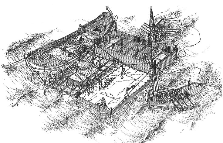
First of all the south mole had to be built to protect the basin against the waves and longshore drift of sediment. The work was done from two artificial islands: one in the middle of the future mole, the other at the end. Both islands were built of several wooden caissons filled with concrete. The next step was placing wooden formworks between the islands for containing hydraulic concrete 12. These concrete blocks, locked to each other by metal clamps, were placed on a floor of rubble and formed a connection between the two islands and the south cape. On this ‘concrete wall’ the mole was built and, at certain distances, towers were erected. In the middle of the mole was a platform (165 x 9 meter) built from sand with rubble and paved with ashlar. This structure was interpreted as a quay. Also at the inner side of the mole several quays, built of rubbish and kurkar 13, were added.
After the southern mole was finished the northern was built. This mole started from the northern cape and ran towards the west. It was built from rubble paved with concrete slabs. On the southern mole rose a lighthouse. The flat coast, without any significant structure, made this lighthouse very important to identify the harbour by night as well as by day. Three of the already mentioned towers were equipped with large sculptures probably about fifteen meters high 15. The towers on the moles were part of the entrance of the basin and obviously meant as mark points. The entrance of the harbour was pointed to the north, away from the west and southwest as most of the storms in this region came from that direction. The third building phase was the prokomia, an extra breakwater south of the south mole to protect that mole against the waves.
The harbour was probably equipped with a system against the fast sedimentation brought in by the sea. There is evidence of a canal system in the southern mole (see figure 4). By making use of these canals, which were located close to the coast, it was possible to let in water from the south. By doing this a water flow was created towards the north of the harbour in order to flush the harbour basin through the entrance into the open sea again. Because of that water flow less sandy water from sea could enter the basin. The same principle was already employed by the Phoenician ports of Sidon and Dor.
The port built by Herod soon became too large for the city. After the annexation of the protectorate of Judea the city was no longer a royal city, but just a province village. There was no need for the large harbour structures. Only the moles were maintained, the other structures were neglected, because the harbour was too expensive 16.
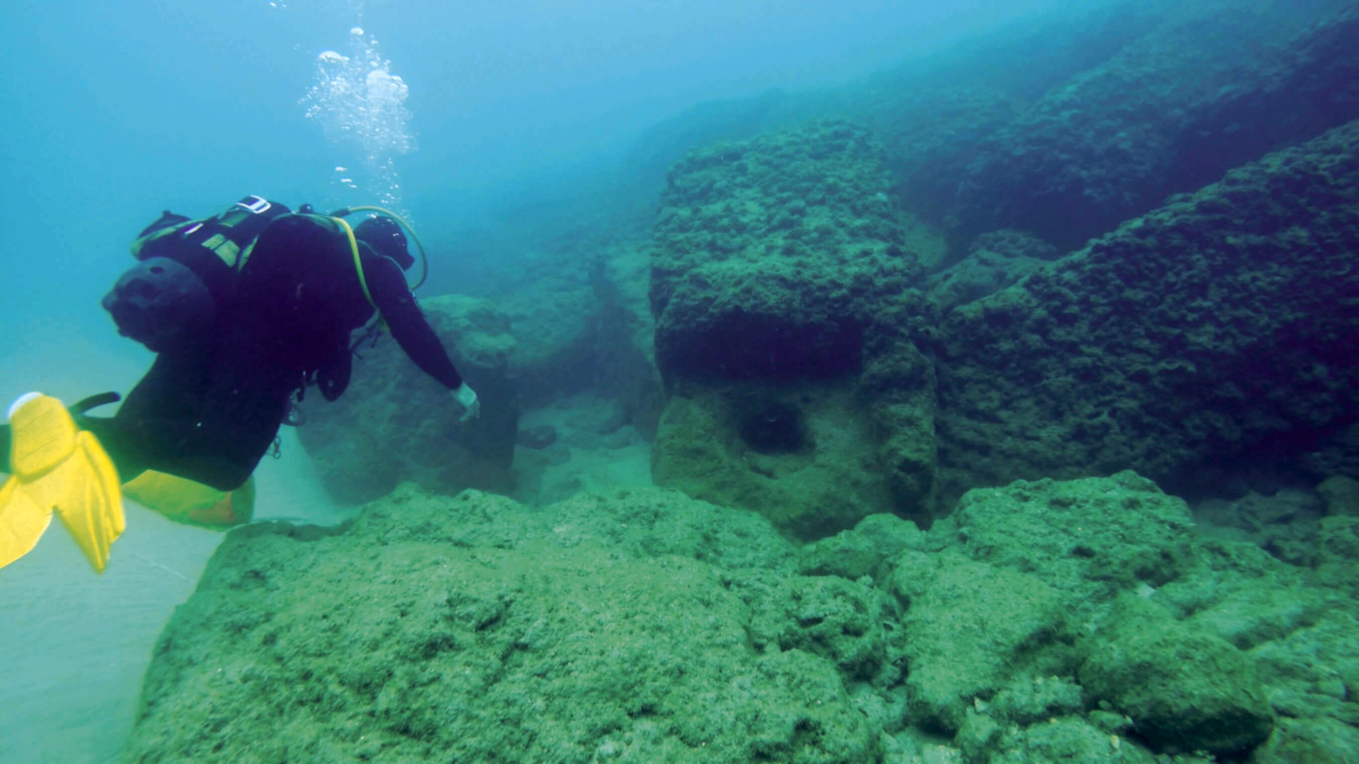 Figure 7: A diver examines the port entrance 17
Modern research
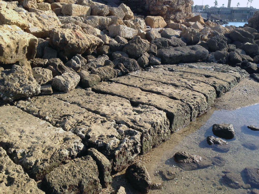
Nowadays the remains of concrete structures of Herod’s new harbour are lying underwater. Underwater excavation and exploration have been carried out since 1960. The Roman Maritime Concrete Study (ROMACONS) investigates maritime structures constructed of Roman hydraulic concrete (see also ‘Pompeiopolis, Roman port in Turkey'). In 2005 they were able to investigate the harbour of Sebastos.
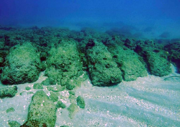
impact of the waves. They once formed part of the jetty shoreward of
the southern breakwater 18
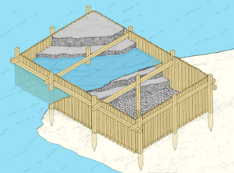
Previous research had revealed at least three different methods employed by the ancient builders to allow the hydraulic concrete to set in a marine environment while contained within wooden shuttering. Why they used three methods is unclear, but this is one of the most striking features of Herod’s project. One method employed a box formed of vertical planks pounded into the ocean floor and then supported by exterior and/or interior horizontal cross beams (see figure 9). Once the wooden formwork was in place, concrete was carefully placed within the box to set. This method was mentioned by the Roman architect Vitruvius 18, and was employed with local variations extensively throughout the Roman world.
ROMACONS took several bore samples (cores). Three of them were taken from the concrete blocks of the southern breakwater. One certainly and the other two probably also showed that the Vitruvius method had been used. The second method existed of barges built with horizontal planks linked by mortise-tenon joinery constructed on or near shore and towed into position. ROMACONS believes that they had most likely been partially filled with concrete in shallow water to reduce their freeboard and susceptibility to the winds and waves and thus facilitate their transport to the desired location. When the barges had been towed to the desired location, they were topped off with concrete until they sank to the bottom (see figure 5).
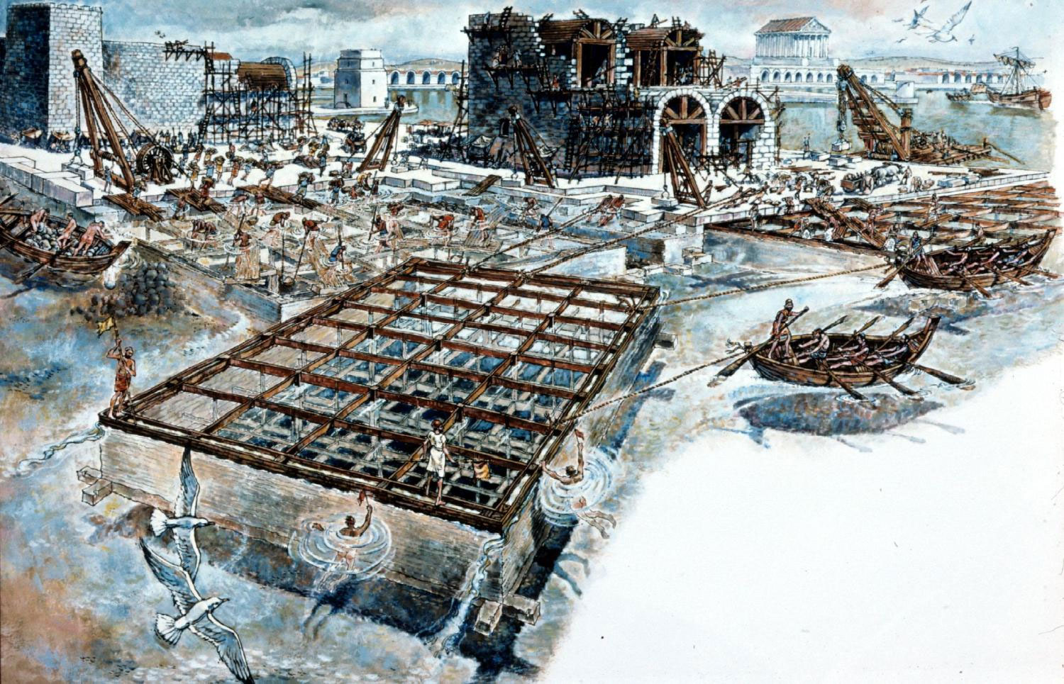
The third method, a variant of the second, discovered by excavators associated with the Caesarea Ancient Harbour Excavation Project (CAHEP), was a caisson system for the concrete that featured a large double-walled hollow box (ca. 15 x 11,5 x 2m), constructed on shore and floated into position by towing (see figure 10). Once in location, the space between the two walls was filled with mortar until the formwork sank to the bottom. Only then was it filled with concrete. This method was used in the northern breakwater.
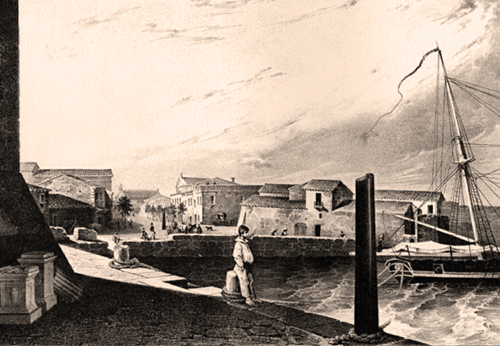
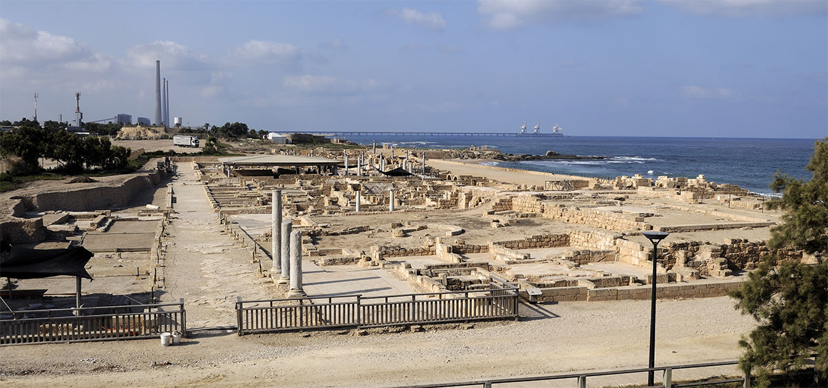 Figure 11: Caesarea Maritima / Sebastos
Record of an eyewitness
“The size of the harbour was not less than that of Pyraeus [at Athens] and had towards the city a double station for the ships. It was of excellent workmanship. This was the more remarkable for its being built in a place that of itself was not suitable to such noble structures, but was to be brought to perfection by materials from other places, and at very great expences. This city is situated in Phoenicia, in the passage by sea to Egypt, between Joppa and Dora. These are lesser maritime cities and not fit for havens, on account of the impetuous south winds that beat upon them, which rolling the sands that come from the sea against the shores, do not admit of ships lying in their station. The merchants are generally there forced to ride at their anchors in the sea itself. So Herod endeavoured to rectify this inconvenience and laid out such a compass toward the land as might be sufficient for an haven, wherein the great ships might lie in safety. And this he effected by letting down vast stones of above fifty foot in length, not less than eighteen in breadth, and nine in depth, into twenty fathom deep. Some were bigger than those dimensions. This mole which he built by the seaside was two hundred foot wide, the half of which was opposed to the current of the waves, so as to keep off those waves which were to break upon them. It was called Procymatia, or the first breaker of the waves. The other half had upon it a wall with several towers, the largest of which was named Drusus. It was a work of very great excellence, and had its name from Drusus, the son-in-law of Cesar, who died young. There were also a great number of arches where the mariners dwelt. There was also before them a quay, which ran round the entire haven, and was a most agreeable walk to such as had a mind to that exercise. But the entrance or mouth of the port was made on the north quarter, on which side was the stillest of the winds of all in this place. The basis of the whole circuit on the left hand, as you enter the port, supported a round turret, which was made very strong, in order to resist the greatest waves, while on the right hand, as you enter, stood two vast stones, each of them larger than the turret, which were over-against them. These stood upright and were joined together. Now there were edifices all along the circular haven, made of the politest stone, with a certain elevation, whereon was erected a temple, that was seen a great way off, by those that were sailing for that haven, and had in it two statues, the one of Rome, the other of Cesar, as the city itself was called Cesarea: which was also itself built of fine materials, and was of a fine structure. Nay the very subterranean vaults and cellars had no less of architecture bestowed on them, than had the building above ground. Some of these vaults carried things at even distances, to the haven, and to the sea, but one of them ran obliquely, and bound all the rest together, that both the rain and the filth of the citizens were together carried off with ease, and the sea itself, upon the flux of the tide from without, came into the city, and washed it all clean. Herod also built therein a theatre of stone and on the south quarter, behind the port, an amphitheatre also, capable of holding a vast number of men, and conveniently situated for a prospect to the sea. So this city was thus finished in twelve years, during which time the King did not fail to go on both with the work, and to pay the charges that were necessary” (Flavius Josephus).
In spite of the positive report of Flavius Josephus, the harbour seemed not to be built for eternity. Seismic action gradually took its toll on the breakwaters, causing them to tilt down and settle into the seabed 21. Also, studies of seabed deposits at Caesarea have shown that a tsunami struck the area sometime during the first or second century 22. Although it is not known if this tsunami simply damaged or completely destroyed the harbour, we do know that by the sixth century the harbour was unusable, and today the breakwaters lie more than five meters underwater.
Since 2000 the site of Caesarea Maritima is included in the "Tentative List of World Heritage Places" of the UNESCO
- Sources:
- - Alexander Cattrysse: Vergelijkende studie van de Romeinse militaire haveninfrastructuren (eerste eeuw v.o.t. – tweede eeuw), University of Ghent 2010.
- - ROMACONS: Constructing the harbour of Caesarea on the sea: new evidence from ROMACONS. The field campaign of october 2005.
- - Arthur de Graauw, www.AncientPortsAntiques.com.
- - Christopher Brandon: Cements, concrete and settling barges at Sebastos - comparisons with other Roman harbour examples and the description of Vitruvius. Pringle Brandon Architects. London 1995.
- - Holum and Hohlfelder: Caesarea 1988, 2000 and 2003.
- Notes
- 1:Titus Flavius Josephus (Roman-Jewish historian (Jerusalem, 37 AD- Rome, 100AD)), Jewish Antiquities XV, 22.
- 2:Stratonos Pyrgos was founded by Straton I of Sidon.
- 3:Titus Flavius Josephus: The Jewish War.
- 4:Aryeh Kasher (1990): Jews and Hellenistic Cities in Eretz-Israel.
- 5:Artist's impression: https://www.pinterest.com/alkkndr/ancient-world-map-caesarea-maritima-israel/.
- 6:Oleson & Brandon, 1992: 51.
- 7:Ashlar: fine stone masonry.
- 8:Alexander Cattrysse.
- 9:Blackman & Rankov 2013: 45.
- 10:Raban 2009: 55, 57,
- 11:Raban 2009: 69-70.
- 12:See also Pompeiopolis.
- 13:Quartz sandstone with carbonate cement.
- 14:Photo 6: Jacob Sharvit for SEGULA Jewish History Magazine.
- 15:Hohlfelder 1992: 77.
- 16:Viereck 1975: 268.
- 17:Photo: SEGULA Jewish History Magazine.
- 18:Marcus Vitruvius Pollio, Roman author, architect, civil engineer and military engineer during the first century BC: De Architectura.
- 19:Photo: Jacob Sharvit for SEGULA Jewish History Magazine.
- 20:Illustration: © National Geographic Society.
- 21:Holum, K. 1988. King Herod’s Dream: Caesarea on the Sea. New York: Norton.
- 22:Reinhardt, E., Goodman, B., Boyce, J., Lopez, G., Hengstum, P., Rink, W., Mart, Y., Raban, A. 2006. “The Tsunami of 13 December A.D. 115 and the Destruction of Herod the Great’s Harbor at Caesarea Maritima, Israel.” Geology 34:1061-1064.
- 23:Photo: http://beautifulcity2015.weebly.com/caesarea-maritima.html.


 We are committed to providing versions of our articles and interviews in several languages, but our first language is English.