Introductie
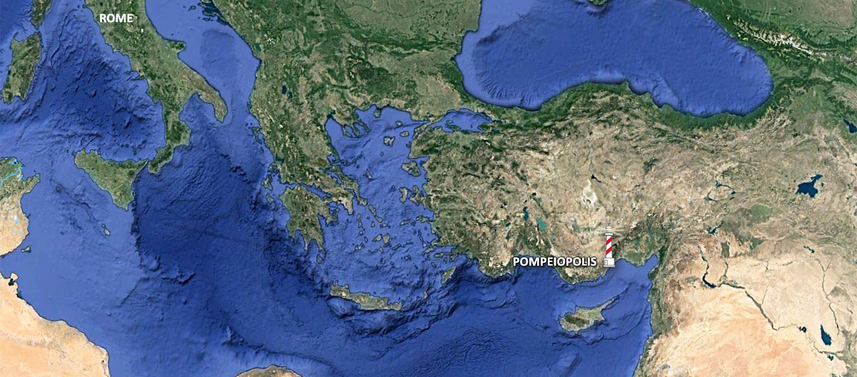
Today let’s talk about a relatively unknown Roman port on the south-eastern Mediterranean coast of Turkey, the port city of Soloi or Soli/Pompeiopolis. A few years ago the ruins of this city came in the picture again because of a special examination carried out in the ancient port by Romacons (Roman Maritime Concrete Study) 1. But let's first look at the history of this settlement.
The beginning of settlement in the Mersin area dates back at least to neolithic times, as evidenced by the remains of human activity discovered on the mound of Yumuktepe. Another mound, discovered near Pompeiopolis, was hiding ceramics dating back to about 1500 BC. The researchers speculate that the settlement called Ellipra existed here under the influence of Hittites 2. The Hittite-era harbour at Soloi furnished bronze age traders access to important timber and metal resources in the Taurus Mountains directly behind the site.
Greek settlers came to the area about 700 BC from the island of Rhodes, and founded a colony that they called Soli. Over time this village grew to a significant city and became the capital of the province at a time when the Persians ruled Asia Minor. During this period, Soli was minting its own coins, which indicates a high degree of autonomy. Later the city was controlled by the Athenians, and then by the troops of Alexander the Great. In Hellenistic times, under the rule of the Seleucid dynasty 3 Soli continued to grow and prosper.
When the state of the Seleucids gradually lost its importance at the turn of the second and first centuries BC, Soli went through a difficult period. The cities located on the eastern coast of the Mediterranean witnessed the growing threat posed by the Parthians and the Arabs. The city of Soli was plundered and its inhabitants were resettled to Eastern Anatolia.
Soli becomes Pompeiopolis (the town of Pompeius)
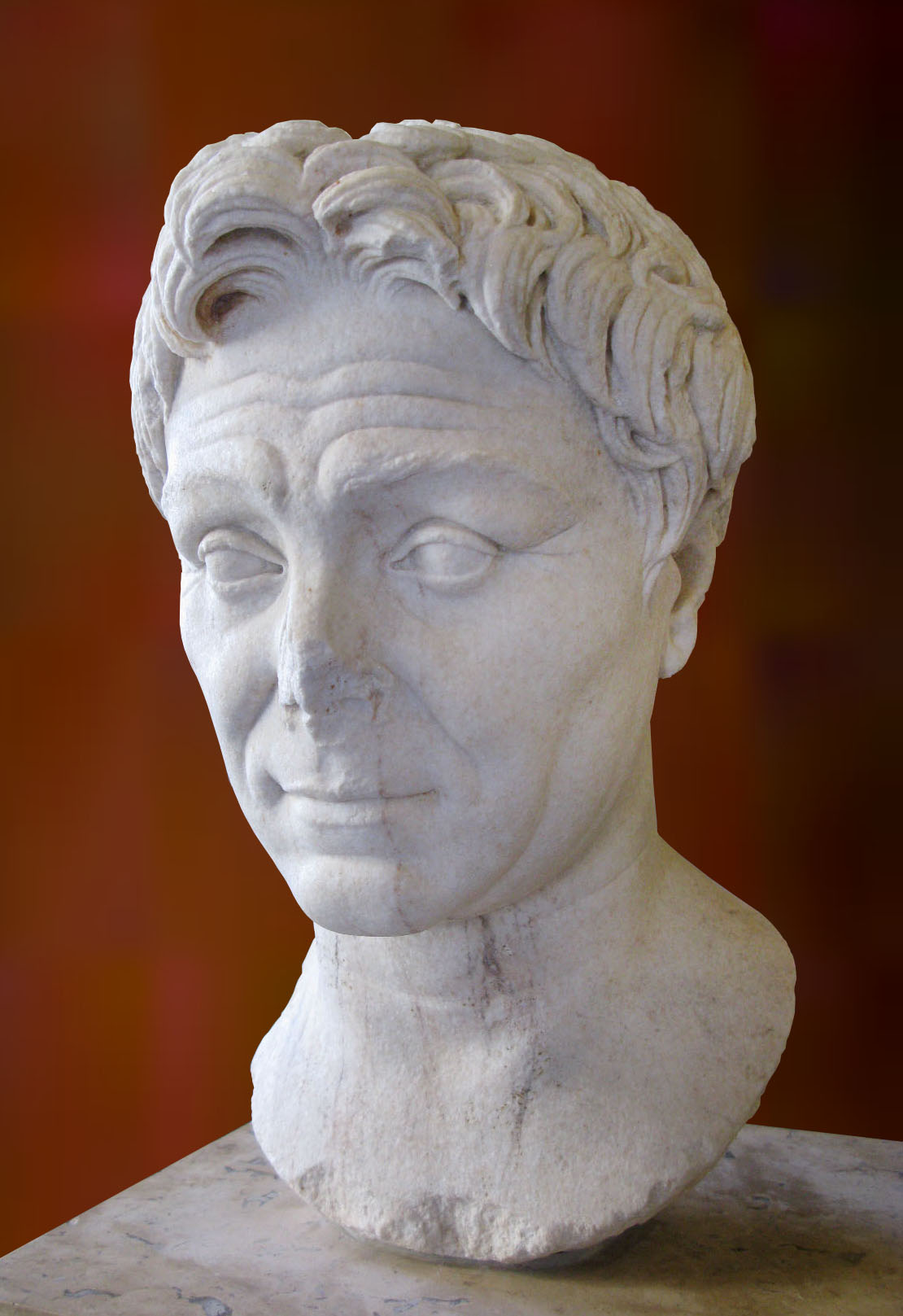
The revival of the city came with the arrival of the Roman general Pompey to Asia Minor in 68 BC. He used Soli as his naval base during the campaign against the Cilician pirates 5. After the victory over the pirates Pompey pardoned and settled many of them in Soli. From this moment the city was known as Pompeiopolis, in honor of the great leader. The city was then surrounded by new defensive walls and many public buildings and roads were built.
In 130 AD the province of Cilicia was visited by the emperor Hadrian, who donated money for the expansion of the port in Pompeiopolis. The seaport played a significant role in the development of Pompeiopolis as an important source of income for its residents.
In 525 AD Pompeiopolis was completely destroyed by a powerful earthquake and never regained its former importance.
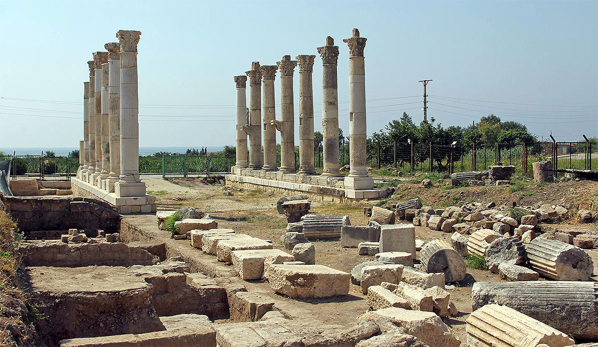
Not much is left of the once important port city, but fortunately 41 columns along its main road, that led from the northern gate of the city to the port, are still standing. As many as 33 of these columns have retained their capitals, and additionally those standing on the southern side also have bases on which the statues of Roman emperors and local dignitaries once stood. Apart from the impressive colonnade one can find the remnants of other ancient buildings, including parts of the harbour wall. This article tells about that harbour and especially about a famous Roman invention, hydraulic concrete.
Roman hydraulic concrete
After a report in Nautical Archaeology 7
After its first appearance in the late 3rd century BC in the Gulf of Pozzuoli, this technology rapidly spread to the far ends of the Mediterranean between the 2nd century BC and the 2nd century AD. The final version of the harbour of Pompeiopolis was built during the flourishing of this technology, some time between the end of the 1st and the middle to late decades of the 2nd centuries AD.
The Roman concrete used for underwater construction consisted of a mixture of slaked lime, pozzolana and aggregate. Pozzolana, a particular type of volcanic ash found near Puteoli in the Bay of Naples, was composed of particles rich in aluminosilicates (aluminium, silicon and oxygen) and shaped such that they had large surface areas. These particles reacted with lime in the presence of water to produce a series of hydrated calcium aluminates and silicates, which caused the mortar to set into a solid mass with the aggregate, even in the absence of atmospheric carbon dioxide, a situation characteristic for underwater structures. The aggregate (caementa) was added to increase the compressive strength and reduce the amount of mortar needed. Already in 2001 there was an investigation about the use of this material in several Roman harbours 9. Romacons got the opportunity from the Turkish government to compare the results with a Turkish harbour, the harbour of Pompeiopolis.
The harbour
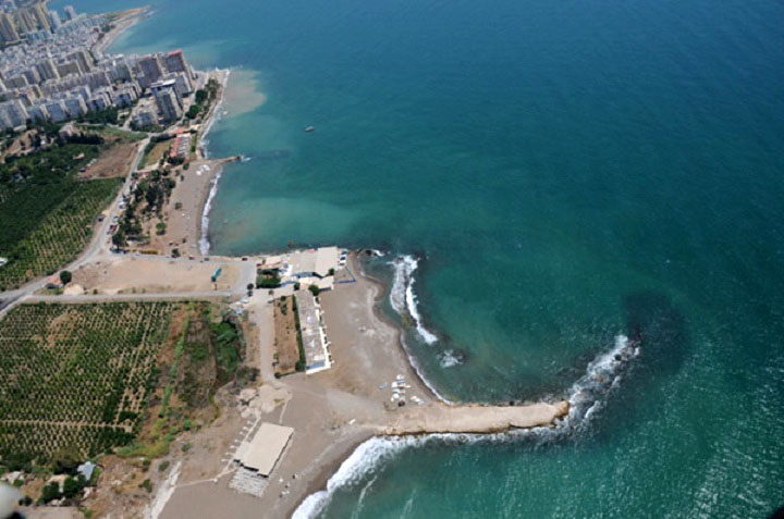
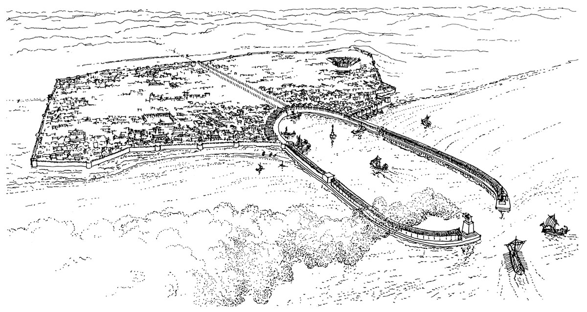
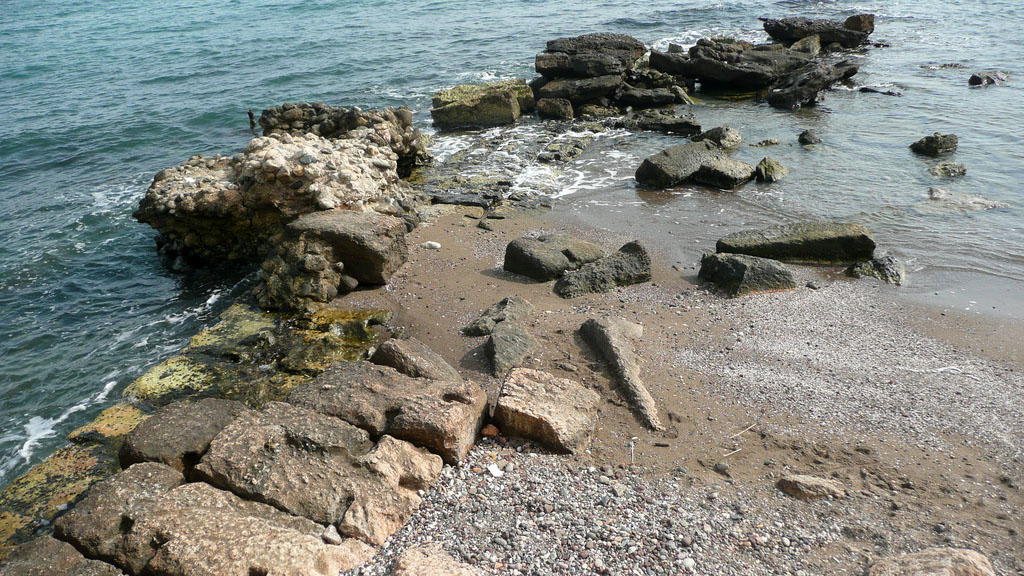
The harbour of Pompeiopolis had two opposed, curving moles 320 m long and ca. 23 m wide, set 180 m apart, which joined on the landward end in a semicircle. The seaward ends curved inwards to frame the harbour entrance. Most of the eastern mole has now disappeared, and the landward half of the moles is surrounded or covered by silt and sand.
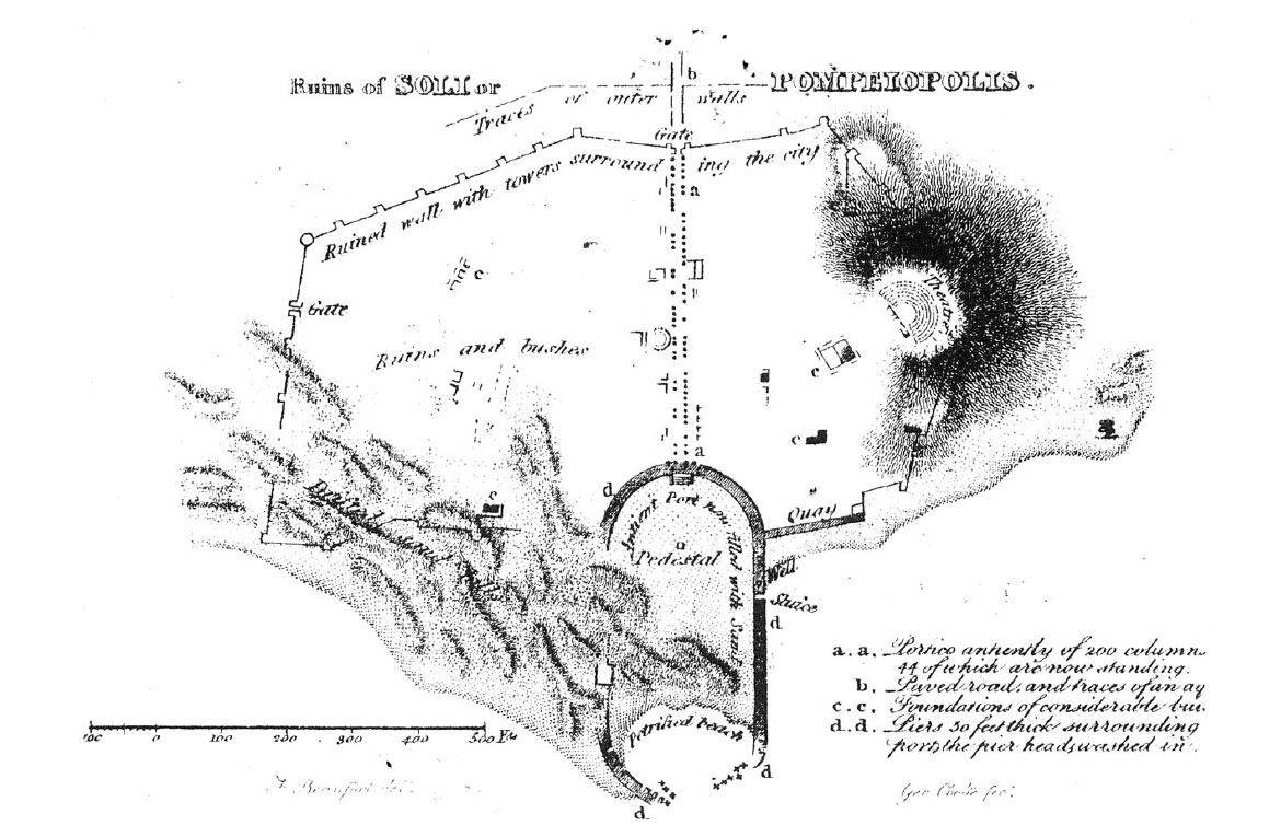
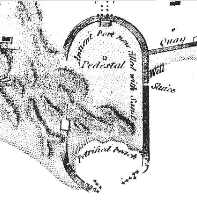
The shape of the harbour was first illustrated in the modern era by Sir Francis Beaufort, who surveyed the southern coast of Turkey between 1811 and 1812. Although the harbour has continued to deteriorate and has in part been built over since it was recorded by Beaufort, it is still possible to make out its plan from aerial photographs, and a substantial section of the western jetty survives in surprisingly good condition. Beaufort’s plan shows the site much as it is today, with over three-quarters of the basin landlocked and sand-dunes covering most of its western side.
The western mole is the better preserved of the two, although only 160 m of it is now visible. The curved outer head lies in ruins, scattered on the sea-bed, while the landward length is buried under sand and under the road skirting the ancient basin. The western section, which still stands in the sea, has survived because it was founded on a natural reef, while the eastern arm was built on sand. The absence of a firm foundation for this structure allowed its seaward length to collapse and essentially disappear.
The harbour structures
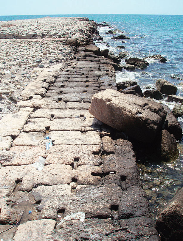
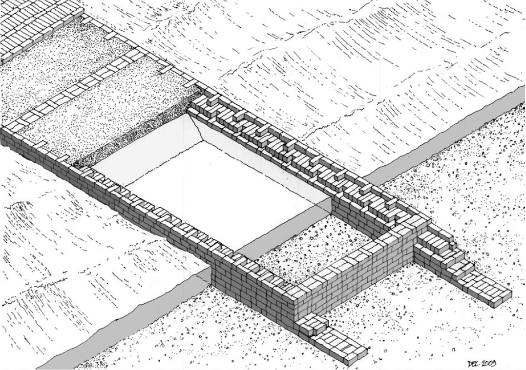
Both moles were framed on the outside by double walls of ashlar masonry. Cross-walls, constructed at irregular intervals, divided the area into large boxes to be filled with hydraulic concrete. A type of permanent ashlar formwork. The lower portions of the outside walls appear to be up to 2.8 m thick, constructed with approximately-uniform stone blocks 1.6 m long by 0.6 m wide and 0.6 m deep. A distinctive feature is that each block was secured to the adjacent blocks with large butterfly-clamps set into the upper surface of the stone. No clamps have survived, but deep cuttings remain visible, 35 cm long by 5 cm deep, and varying in width from 6 cm at the ends to 3 cm at their midpoints. There were up to 6 clamps per block. The extraordinary size of the clamp-sockets suggests that the clamps were made of wood rather than metal.
Four cross-walls are clearly visible on the exposed surviving length of the western breakwater, set at 34 m, 30 m, and 14 m apart to form the cells into which the concrete was placed. The cells were probably built out into the sea one-by-one and in-filled with concrete as each was completed. This form of enclosure was not watertight, and the compartments would have flooded to sea-level, requiring that the lowest stratum of the concrete be laid under water. The upper layer in each cell was then filled with what appears to be a poorer-quality concrete, ultimately paved with stone slabs.
Errors in the reconstructed plan
Beaufort’s plan shows the colonnaded street, which is still visible today, running inland from the harbour along the central axis of the basin. Aerial and land surveys now show that the street was not on axis with the harbour, but off-centre by some 20 m to the east. This was obviously a deliberate design decision, but one that seems perverse when set in the context of the geometrical symmetry of the harbour basin. This deviation from symmetry would, however, make sense if at some stage a river, or a canal leading from it, ran through the city and flowed into the harbour. It may well have been that throughout its Roman existence the river flowed next to or beneath the colonnaded street which led from the city to the harbour itself. From the latest research emerged the evidence that a river, now known as the Mezitli River, once debouched into the sea where the Roman harbour stood. Coring uncovered river alluvium in the vicinity of, and possibly under, the western breakwater.
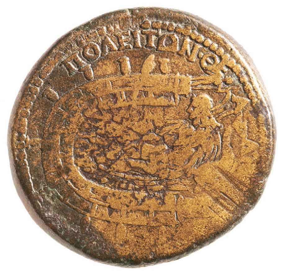
The coin of Antoninus Pius
Romacons has also shed some additional light on a bronze coin, struck sometime during the reign of Antonius Pius, which featured the harbour of Pompeiopolis as its reverse type. This remarkable and rare issue was the focus of a detailed, valuable article by A. A. Boyce in 1958. In this she discussed the general iconographic traditions for harbour types, the particular architectural features of this Pompeiopolis issue, the possible identification of the reclining male deity which consumes much of the space between the two breakwaters in the reverse field (Boyce’s preferred date for the issuing of the coin was AD 143/44, 209 years after the founding of Pompeiopolis in 66/65 BC). She suggested that Hadrian possibly began a renovation of the harbour, perhaps to celebrate the bicentennial of the city’s foundation, but this was only completed in the reign of Antoninus Pius, his adopted son 15. Both emperors were interested in the maritime infrastructure of the empire and were particularly known for their patronage of harbours.
Besides the text and the figure there are many representations of structures which once stood on the breakwaters. Unfortunately all evidence of these architectural features has vanished, either through robbing for pillage or recycling, or through the destructive force of nature over the centuries.
Romacons provided a chronological confirmation for the construction of the breakwaters. C14 analysis of a wood fragment found in a core sample resulted in a midpoint of 147-148 AD. In other words, the two surviving but ruinous breakwaters seem to date from the Hadrianic-Antonine era and not from any harbour installations constructed when Pompey re-established Soli as the city that bore his name.
The beginning of a major harbour construction project by one emperor and its completion by his successor was not unique to Pompeiopolis. Boyce mentioned that a similar situation occurred at Portus, the harbour complex near the mouth of the Tiber. There construction started during the reign of Claudius (AD 41–54), but a commemorative coin with the harbour as a reverse type was not issued until late in Nero’s reign. Imperial Rome’s new harbour was clearly functioning before the coin was struck in AD 64, but perhaps all the maritime structures built around the harbour had not been completed before that year, or, more likely, it was struck that year to announce the completion of harbour repairs by Nero following the natural disaster which caused the sinking of 200 ships within the harbour in AD 62, and to signal to the Roman world that the imperial harbour was once again fully functioning.
Because there was a river which once debouched into the harbour basin, the reclining figure on the reverse type may well be a personification of a local river-god, or Portunus (a deity associated with the harbour itself), or Oceanus, or possibly all three. A figure honouring three divine manifestations for river, harbour and ocean might well have been intended to show the interconnectedness of all these elements in the prosperity of the city. If so, this iconography ingeniously captured the role of this harbour as a maritime gateway for the region it served.
Boyce’s identification of the structure at the end of the western or lower breakwater on the coin as a lighthouse seems very likely, although no trace of such a structure exists today. Boyce’s suggestion that this structure could have been an altar seems much less likely, as large altars at the end of breakwaters are otherwise unknown. One would expect a lighthouse to have been located precisely at the mouth of a harbour.
But if Boyce is correct in that assumption, her explanation that a series of ‘jar-like objects’ which adorned the two-storied structures which stood on the breakwaters were possible fire beacons, to mark the harbour or to assist navigation into the harbour in bad weather, seems less likely. Such beacons would have been difficult to operate and maintain and would have been redundant, given the proposed location of the lighthouse. A lighthouse would have served to guide ships to the harbour entrance, and in difficult weather it is not likely that any large vessel unfamiliar with the quirks of the Pompeiopolis harbour would have attempted to enter it under sail. Local rowed tenders or tugs would more probably have guided these vessels to safe moorings within the harbour, regardless of sea conditions. No trace of these jars has been found, and, even more unfortunately, no evidence of any harbour structure on which they once may have stood has survived.
Boyce also suggested that what she called a ‘feathershaped object’ located between two of the ‘jars’ might have been a sail, placed on top of the second storey of the structure on the east breakwater to indicate the direction and relative velocity of the wind.
Beaufort versus the coin of Antoninus Pius
The Antonine coin does not display two features which appear in Beaufort’s plan of the harbour. One was a putative statue-pedestal at the back of the basin close to the point where the river might have entered the sea. No evidence for such a structure is visible today, and its proposed location now seems to be covered by earth. Did the pedestal really exist, or was Beaufort wrong a second time in his sketch-map, as he clearly was when he showed the colonnaded street leading to the harbour on axis with it? Was this pedestal added some time after the coin was struck, or was the statue which stood on it too insignificant to attract the interest of the die-engraver of this coin? There are no discernible answers to these questions. The other feature missing from the coin representation was a break in the eastern breakwater, which Beaufort identified as a sluice-gate, intended to allow water moving from east to west in the current that runs offshore to enter the enclosed basin to help reduce siltation. No identifiable trace of its existence appears in the washed-out sections of the eastern breakwater, although, as with the hypothetical statue-pedestal, it may await discovery beneath the alluvial fill which now covers much of the ancient harbour basin. These two disconnects between the coin-type and the 19th century plan are mysteries that defy easy resolution.
notes:- 1: Click here for the whole article of Romancons.
- 2: Hittites were descendants of Heth (great-grandson of Noah). They possessed during the 14th to the 12th century BC a mighty empire in Asia minor and Syria, more powerful than Egypt and Babylonia.
- 3: The Seleucid Empire (Ancient Greek: Ἀρχή Σελεύκεια / Arche Seleúkeia) was the largest successor state of the Macedonian empire of Alexander the great in the Near East from 311 till 63 BC.
- 4: Photo 2: the statue is now in the Louvre, Paris. Author: Alphanidon.
- 5: Pirates from Cilicia: a region in modern-day southeastern Turkey.
- 6: Photo 3: Mersin Haber Imece.
- 7: Christopher Brandon, Robert L. Hohlfelder, John Peter Oleson and Nicholas Rauh, "Geology, Materials, and the Design of the Roman Harbour of Soli-Pompeiopolis, Turkey: the ROMACONS field campaign of August 2009", Nautical Archaeology 39.2 (2010), 390-398.
- 8: C. Brandon.
- 9: Brandon, Hohlfelder and Oleson - the Roman Maritime Concrete Study (ROMACONS), 2001.
- 10: Photo 5: Prof. Remzi Yağci.
- 11: Beaufort 1817, 240.
- 12: Photo 12: Romacons
- 13: C. Brandon.
- 14: Bronze coin of Antoninus Pius, reverse (American Numismatic Society).
- 15: Boyle bases this assumption on the text: after the word poleiton (population) are the letters theta and sigma.


 We are committed to providing versions of our articles and interviews in several languages, but our first language is English.