By Tonnie Huijzendveld (Arnoldus)
Geoarchaeologist
The two breakwaters
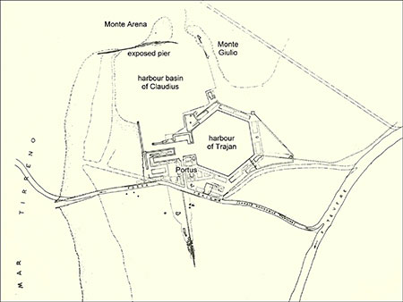
Pope Pio II in his Commentaria Rerum Memorabilium1 (May 1463) wrote: “Emperor Claudius built a harbour protected right and left by jetties, with a mole at the entrance where the sea is deep.” The harbour basin of Claudius is located about 2 km north of Ostia, near the Roman town of Portus
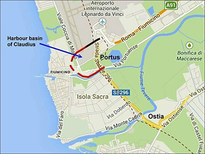
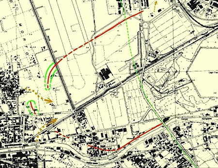
with in black the exposed part of the moles and in red
the “hidden” parts; a dotted line indicates the Roman
coast.
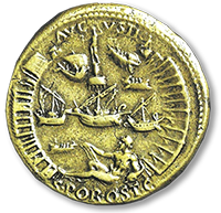
Construction commenced in A.D. 42 and was completed by Nero in the year 64. On the occasion of the inauguration, the emperor authorized the production of a series of bronze coins depicting details of the port on the reverse. The harbour of Claudius is depicted in great detail, with merchant ships floating in the sea, the two breakwaters curving on either side of the coin, and the sea entrance with a central lighthouse and statue.
harbour basin of Claudius;
the sea is on top of the image,
north is to the right.2
Further to the west no traces of the breakwater can be seen at the surface level. In fact, trenches excavated under the auspices of the Soprintendenza Archeologica di Ostia uncovered no remains of this breakwater, even at the depth of several meters.
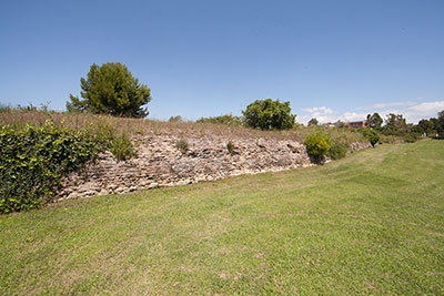
Claudius exposed behind the Museo delle Navi of
Fiumicino; photograph Gerard Huissen..
The disappearance of this breakwater is due to the strong growth of the dune belt in historical times, particularly in the last centuries. The moles of the harbour of Claudius were covered by sandy sediments (see article on the coastline of Ostia), and the real size and orientation of the harbour basin were forgotten for centuries..
A forgotten outline
Let’s get a short historical overview of how the basin of Claudius has been depicted.
In the images of the 16th and 17th centuries the basin was always (correctly!) shown to be wide, delimited to the north and south by breakwaters curved toward the western entrance, where the lighthouse island was located.
This mistaken reconstruction has been unfortunately preserved even in recent publications
with a reduced size and a northern main entrance3.
The cause of this misinterpretation is almost certainly the sheer magnitude of deposits which covered the structures during the coastline advancement of the last centuries.
From the 19th through the first half of the 20th century, this wrong reconstruction was generally accepted. In the 1960s it was called into question specifically by Castagnoli and Giuliani4. Aerial photographs, among other things, led these scholars to return to the former hypothesis: a large EW oriented basin.
But even then the size of the harbour was underestimated, as was later discovered.
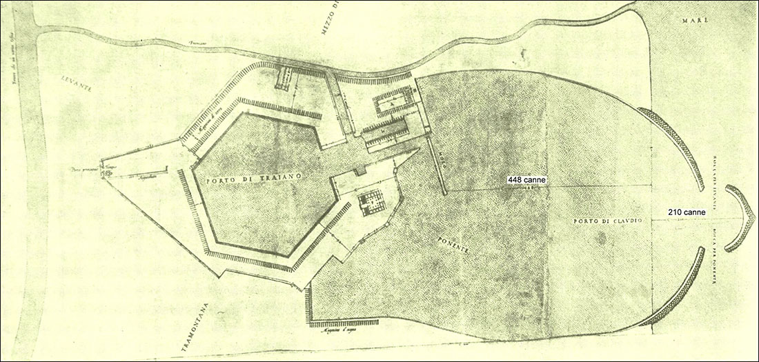
Return to a former idea
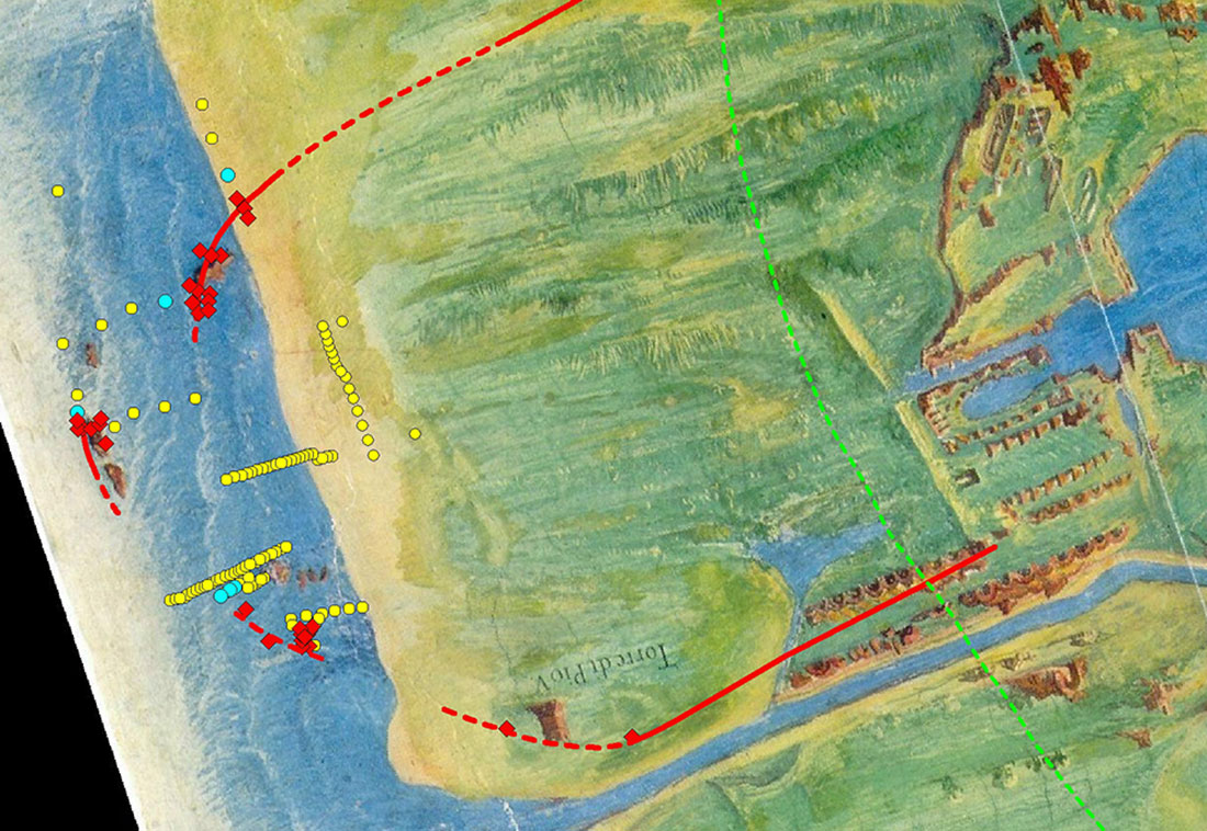
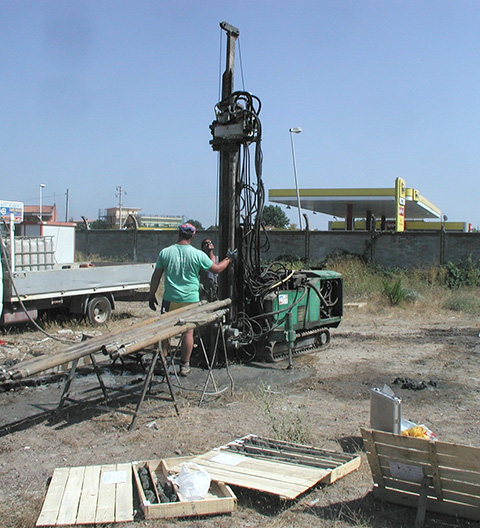
Only in the last decade a series of deep drillings (Fig. 6) have confirmed, without a doubt, that the basin is indeed eastwest oriented and that it juts out farther into the sea than previously suspected: the distance between the inland margin (Monte Giulio) and the lighthouse island is about 2 km.
island and the entrances of the Claudian harbour, based upon
drilling data collected between 2004 and 2007.
The modern reconstruction shows two protruding moles and a lighthouse island, separated by evident entrances5. A third, narrower entrance (probably only a channel) was demonstrated to exist between the northern pier and Monte Giulio6. It is very interesting that the various distances indicated by Antonio Labacco7 map of the 16th century turned out to be approximately correct (see Fig. 4).
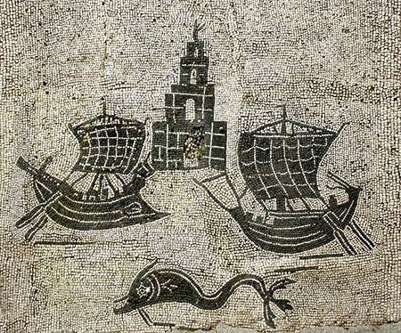
from Ostia and Portus (mosaic in statio 46 on the Square of
the Corporations, Ostia)8
In 1483 Sixtus IV (Francesco della Rovere) visited Portus and wrote "where you can still see the very old walls of the city of Portus, very ruined, and the tower of the Pharos, so much so that it still retains the same name today" ("dove si vedono ancora i muri vetustissimi della città di Porto, molto diruti, e la torre del Faro, tanto che ancora oggi essa conserva lo stesso nome".
After 1483 there are no further references to the lighthouse. Presumably the last remains were demolished soon afterwards
Two different stretches
In the drilling cores executed along the outer stretches of both piers, no hydraulic mortar was encountered, only large blocks of basalt and lithoid tuff embedded in coarse sand, forming a ridgelike rubble mound with a base width of at least 60 meters.
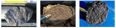
of the moles and lighthouse island: from left to right: basalt,
red lithoid tuff and the same blackened from long immersion
in sea water.
In the westernmost drillings the base of the northern breakwater has been found at a depth of 15-16 meter from the surface. Furthermore, it was found that the level of the sea bed directly beneath the structure is deeper than the surrounding area, with a difference of up to two meters. We may presume that this is due to the weight of the stones sinking into the soft sea bottom, a process that may have started from an early phase of the construction on.
But there is more. De Graauw12 shows how modern, looselypiledup breakwaters undergo a lowering of the top and a widening of the base due to wave action, transforming it from an emerging into a submerged mole. This usually happens in a later phase.
The gradual sinking of the base and lowering of the top of the rubble mounds, combined with the accumulation of sandy sediments due to the changing coastline, helps us to understand why the top of the remains are found several meters below the surface. We must also keep in mind that when the remains were first revealed in the waters close by the advancing coastline, people may have taken stones away from the moles for reuse elsewhere.
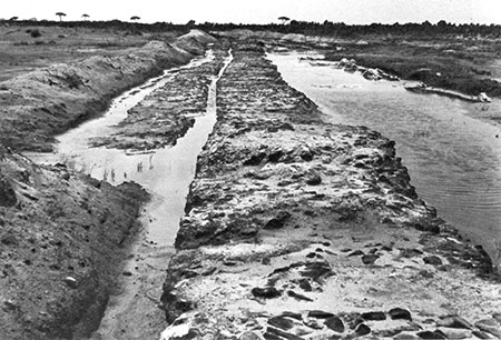
northern mole, view to W16
It has been shown that the western extremity of this construction rests upon a sea bed at a depth (in Roman times) of about 7.5 meters13. This inland stretch was probably constructed, according to the indications of Vitruvius, with wooden formworks filled with hydraulic mortar and stones , eventually resting on top of a rubble mound. It would have been built out from land, using lorries moving over the top of the pier above sea level15 .
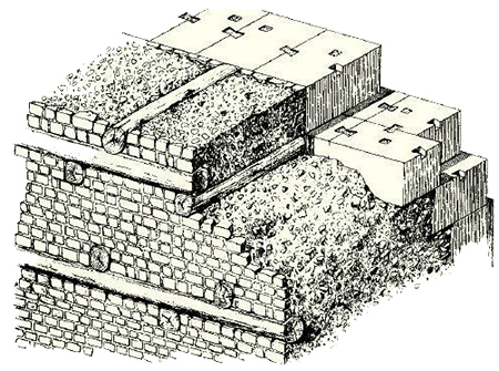
possibly used for the exposed part of the northern breakwater14
The most recent drillings, executed within the Airport of Fiumicino on behalf of the Soprintendenza Archeologica di Ostia, are confirming the direction and base width of the “hidden” part of the northern breakwater as hypothesized earlier by Morelli et al.
Our current hypothesis explaining the difference in preservation of the two stretches of the northern breakwater of the harbour of Claudius is a difference in construction technique: the inner stretch made from caissons filled with hydraulic mortar and stones, against the seaward part made only of stones loosely piled upon the sea bed. The abruptness of the transition between the two stretches, proven to occur at a distance of less than 50 meters, is one of the arguments in favour.
But not everything is resolved and understood, e.g. why didn’t we find, at least up to now, any traces of the arches indicated on the coins along the northern pier?
This topic will be discussed in a next contribution..
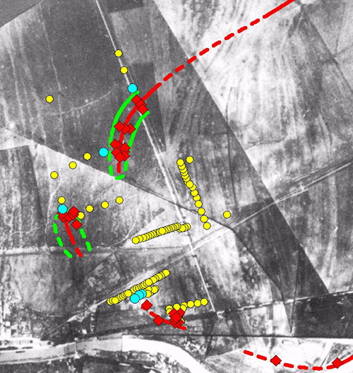
overlain on a photo mosaic of 1911; red diamonds indicate structures
encountered in the drillings; the NS road is the modern Viale Coccia
di Morto..
This text has been published under a Creative Commons License CC BY-NC-SA 4.0. Feel free to publish it on your websites, blogs... under the following conditions: You must give appropriate credit, mention the author and provide a link to this original publication and to the license indicated above. You may not use the material for commercial purposes.
- Notes:
- 1: Original text : http://www.ostia-antica.org/anctexts.htm, Later Texts, Pius II.
- 2: From www.ancientportsantiques.com/a-few-ports/portus/#5. Source: Oleson, 2014 (British Museum)
- 3: Testaguzza O., 1970 - Portus, Illustrazione dei Porti di Claudio e Traiano e della Città di Porto a Fiumicino; Julia Editrice, Roma.
- 4: Giuliani C.F., 1996 - Note sulla topografia di Portus; in: Manucci V. (eds), 1996, Il Parco Archeologico Naturalistico del Porto di Traiano; Ministero per i Beni Culturali Ambientali, Soprintendenza Archeologica di Ostia, pp. 29-44.
- 5: Morelli C., Marinucci A, Arnoldus-Huyzendveld A., 2011 - Il Porto di Claudio: nuove scoperte, in Portus and its Hinterland, recent archaeological research, Simon Keay & Lidia Paroli (eds), Archaeological Monographs of the British School at Rome, pp. 47-65.
- 6: Goiran J.-Ph., Salomon F., Tronchere H., Carbonel P., Djerb H., Ognard C., 2011 - Caractéristiques sédimentaires du bassin portuaire de Claude: nouvelles données pour la localisation des ouvertures, in Keay S., Paroli L. (a cura di), Portus and its Hinterland, Archaeological Monographs of the British School at Rome: 31-45.
- 7: Labacco A. (1552-67) - Libro appartenente a l'architettura nel quale si figurano alcune notabili antiquità di Roma. Roma, Antonio dall’Abacco.
- 8: From www.ostia-antica.org.
- 9: “di questa torre ne veggiamo insino ad hoggi una buona parte in pie, se non che ne sono stati tolti i marmi, dei quali ella era incrustata”
- 10: “ancora rimangono vestigi della torre le quali si vedono là nel mare; tutti gli altri monumenti sono periti interamente”
- 11: Letters LXXI; translation from https://www.gutenberg.org/files/2811/2811-h/2811-h.htm#link2H_4_0071.
- 12: De Graauw A., http://www.ancientportsantiques.com/ancient-port-structures/failure-of-rubble-mound-breakwaters-in-the-long-term/
- 13: Goiran Jean-Philippe, Hervé Tronchère, Ferréol Salomon, Pierre Carbonel, Hatem Djerbi, Carole Ognard, 2010 - Palaeoenvironmental reconstruction of the ancient harbors of Rome: Claudius and Trajan’s marine harbors on the Tiber delta, Quaternary International 216 (2010) pp. 3-13.
- 14: De Graauw A., http://www.ancientportsantiques.com/a-few-ports/portus/#5.
- 15: De Graauw A., http://www.ancientportsantiques.com/a-few-ports/portus/#5.
- 16: Testaguzza 1970 p. 85.


 We are committed to providing versions of our articles and interviews in several languages, but our first language is English.