Geoarchaeologist
Nowadays the sea is distant a few kilometres from the ancient city of Ostia. Evidence from classical sources, however, reveal that in Roman times the sea was actually very close by (see contribution on the Synagogue). Minucius Felix, for example, gives an eyewitness account of a walk from Ostia to the sea in the 2nd/3rd century A.D. After a vivid description of the beach and the sea, he writes: “Let us sit down on that rocky mole projecting into the sea, which has been made to protect the baths”. So obviously at the time the sea was not only close by, but also invading the coast and threatening the buildings of Ostia.
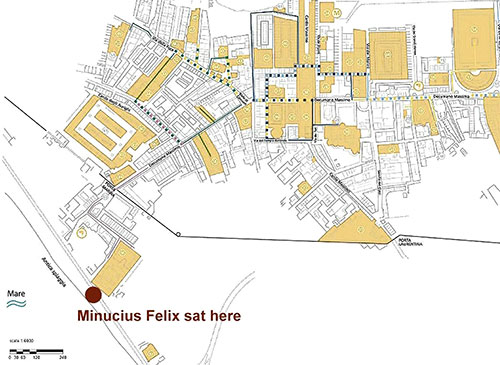
where Minucius Felix, describing the sea, was probably sitting
The position of the coast in the early centuries A.D., and, more generally, the original configuration of the coastal belt, has been masked by dune sand and alluvial sediments of the Tiber.
Let me go back farther in time, and explain shortly the mechanism of coastline withdrawal and advancement, and from that viewpoint the environmental history of the coastal plain of Rome. These processes have been investigated mainly through deep drillings, followed by analysis of the core contents and radiocarbon dating. Generally, the position of a coastline is determined by two factors: 1) the marine water level; 2) the quantity of sediment that is transported to the sea by the rivers. Geological research has proven that until about 5,000 years ago, the marine level played a major role in determining the position of the coastline: between ca. 17,000 and 5,000 years ago, the sea has gradually risen from about minus 125 meters to a stable level not dissimilar from today. This process of “drowning of the beach” implies an inland movement of the coastline. It is generally accepted that this marine rise was due to the melting of the polar ice caps after the end of the last great glacial period of 20,000 years ago. Small sea level variations have also occurred afterwards, e.g. in the first centuries A.D. the sea level was still ca. 1 meter lower than today.
(the arrows indicate the position of the photograph of figure 4)
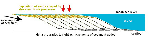
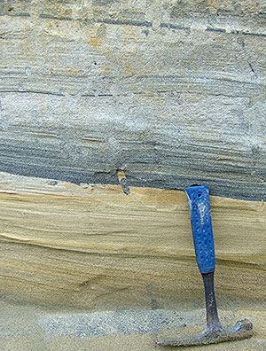
The dunes of the coastal belt are composed of a series of beach ridges, each the final product of a coastal barrier formed initially on the seabed under the influence of waves. Each barrier has migrated slowly inland, to ultimately be welded to the coastline. The sandy material that makes up these sediments, was transported first by the rivers to the sea, and then by marine currents back to the shoreline. The sand suspended by the waves that reach the shore area is deposited on the beach, and then partly removed during the next withdrawal. If the successive wave is very strong, the sediment is completely eroded, and we are witnessing the beginning of a new cycle. The beach ridges may instead survive where there is an abundance of solid load of the rivers, and thus of the sea . In that case a sedimentary sequence is formed composed horizontally of an alternating series of dunes and interdunal depressions, which reflects the cyclic nature of the processes.
of the coastal plain of Rome. The growth
occurred horizontally, in a sequence of
a large bands developing seawards, here
from left to the right
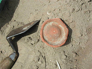
a trench north of Portus
We have seen how the sediment load of the river, the strength and direction of the marine currents and the force of the waves in the shore area are in a delicate balance, which in the long run can lead to an increase, to a standstill or to a withdrawal of the coastline. Thus the intensity of river discharge and inundations, determined by climatic conditions or by erosion in the watershed, becomes a potential factor in the shoreline evolution.
A challenging and unitary model on the development of the strand plain of the coastal area of Rome over the last millennia was provided by Bellotti et al. 2011.
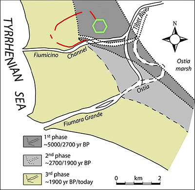
location during the strand-plain evolution
With the opening of the channel of Trajan (early 2nd century A.D.) a new complex system of delta progradation developed, with two river branches active almost simultaneously (the third phase). The process coincided with frequent flooding of the Tiber; in Roman times about thirty floods were recorded. The advance of the coastline was initially slow, then of greater magnitude: about half of the advancement occurred from the 16th century A.D. on.
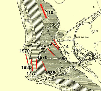
times; numbers indicate years A.D.
Although the above-mentioned environmental changes were strictly controlled by the local conditions, they also reflected rapid worldwide climatic changes. So the 3rd century A.D. erosion phase reveals a warm climate episode, characterized by a decrease of the Tiber floods, whereas the progradation of the last 500 years coincides with a colder climatic phase (the ‘Little Ice Age’) and the registration in the coastal belt of Rome of the highest and strongest floods ever.
Based upon the drilling data, the aforementioned authors have developed an interesting hypothesis on the foundation and growth of Ostia: around 2600 years ago the Stagno Ostiense was affected by a sudden environmental change through the input of sea water, which transformed the basin from lacustrine to brackish. This transformation coincided chronologically with the period of foundation of Ostia according to tradition. We do not know whether the sudden change was natural or due to human influence. At any rate, the width of the dune belt was too small to accommodate a real city, as Ostia was later to become. The hypothesis is that, at the time, it was only an outpost, possibly related to salt production. The delta advanced seawards very quickly, at an estimated progradation rate of 5 – 6 m/year, so that by the 5th / 4th century b.C. it was almost fully developed. The hypothesis is that by then the dune belt was wide enough to allow the foundation and expansion of the city of Ostia.
It may sound strange, but examples of advancing coastlines are scarce nowadays. I know of only one expanding beach in Italy, to the south of Grosseto in Tuscany.
The present-day tendency is instead an overall retreat of the beach. This is not so much due to a rise of sea level, which has been only 12 cm in the last century, but mainly to the scarcity of sediment transported by the rivers to the sea. This can be considered to be a condition inverse to the abundance of river bed load available in the centuries before.
This text has been published under a Creative Commons License CC BY-NC-SA 4.0 . Feel free to publish it on your websites, blogs... under the following conditions: You must give appropriate credit, mention the author and provide a link to this original publication and to the license indicated above. You may not use the material for commercial purposes.
Notes:- Fig. 2: Modified from www.ostiaantica.beniculturali.it
- Fig. 3: Bellotti P., Calderoni G., Di Rita F., D'Orefice M., D'Amico C., Esu D., Magri D., Preite Martinez M., Tortora P., Valeri P., 2011, "The Tiber river delta plain (central Italy); Coastal evolution and implications for the ancient Ostia Roman settlement", in the Holcene 2011 21: 1105, originally published online 26 May 2011 DOI: 10.1177/0959683611400464
- Fig. 6: Modified from Dragone F., Maino A., Malatesta A, & Segre A.G., 1967 - Note illustrative della C.G.I. alla scala 1:100.000. Foglio 149 (Cerveteri). Serv.Geol.d'It., pag. 63
- Fig. 7: Modified from Bellotti et al. 2011


 We are committed to providing versions of our articles and interviews in several languages, but our first language is English.