Preface.
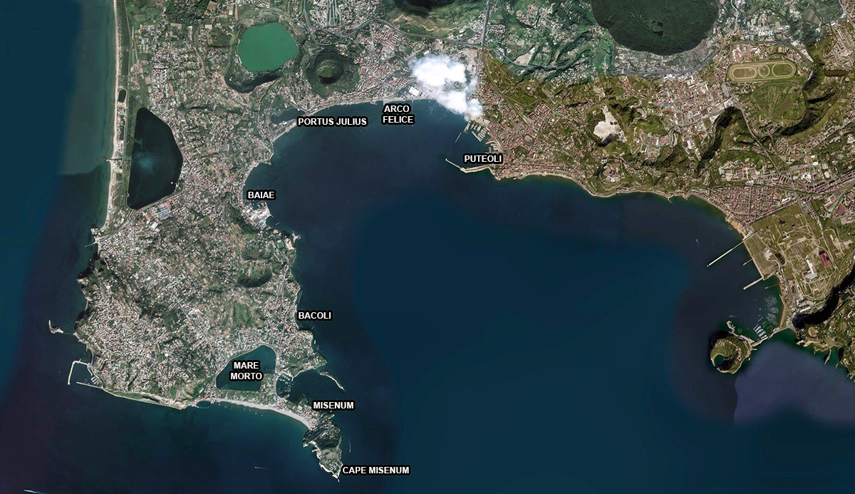
Campi Flegrei or the Phlegraean Fields (burning fields) is a long volcanic area to the west of Naples, Italy. The area of this cadera (super volcano in this case consisting of 24 craters) lies mostly underwater.
Originally there were some Greek settlements in this region. From the 4e century BC this part of today’s Italy became under Roman rule. The area was then still quite inaccessible by the dense afforestation of the so-called Silva Gallinaria, in which many bandits and outlaws took refuge. Besides that, like at Ostia, there was a lot of malaria. After the hack of the forest new residential communities were founded such as Baiae.
The Romans built several ports in this area with the port of Puteoli (modern Pozzuoli) in the centre. This article from Cristiano Fiorentino is about those ports.
By Cristiano Fiorentino
The civil port of Puteoli
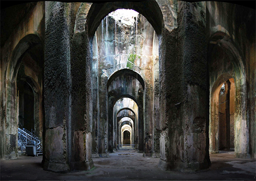
Before the birth of Trajan’s Portus2, Puteoli was an ad-hoc port for the Roman Empire and consequently the city availed incredibly. From every wind direction all kind of things were imported such as spices, slaves, wine, ceramics, precious objects for the Roman market and, not to forget, grain for the food supply of Rome, brought by the Alexandria Fleet (classis Alexandrina). This grain was temporarily stored in large horrea (storehouses) which stretched from the Port of Puteoli to the ‘Arco Felice’ along the coast of Puteoli. Here the grain was sorted first and after that transported to the capital and the rest of the empire.
The port complex, in this form going back to the beginning of the empire was terrible damaged by a storm at the time of Hadrian. The promised reconstruction was carried out by his successor Antoninus Pius in 139 AD, as can be read on an inscription found in the waters of the port: opus pilarum vi maris conlapsum a divo patre suo promissum restituit 3.
The decline of the port of Puteoli
With the rise of the port of Tranjan at Portus, Puteoli loses her preference when the partial Alexandrian fleet was moved over to that port, closer to Rome. Nevertheless, an important role for Puteoli remained for a long time. In particular with regards to the contacts with the African coast.
Eventually, after a while the port falls into decay lttle by little. Whether it came by the declining numbers of visitors or the problems with the silting up due to bradyseism5, or of course by the serious crisis in the empire, fact is that between the period at the end of the Western Roman empire up to the middle ages, Puteoli became totally desolated.
The port of Misenum.
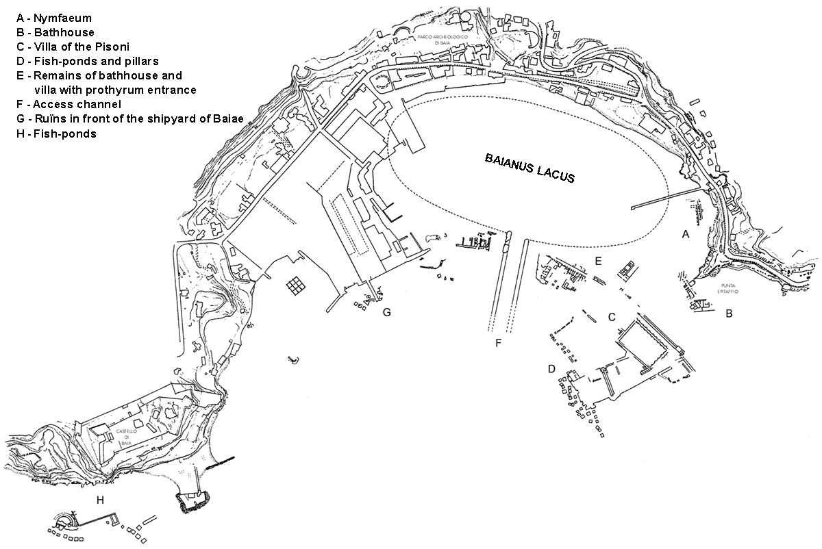
Lake Bacoli, also called lake Miseno was a natural lake and the inland part of the harbour of Misenum consisting of two basins. Lake Bacoli had a circumference of about 3 km and was also called Maremorto (dead sea). In ancient times it was used as a shelter and for the maintenance of the ships.
The basin located at the outside was the actual harbour. Between the two basins historians suspect a port infrastructure and a shelter for the military fleet of Misenum (the classis Misenensis).
Next to the port was a large cistern, called Piscina Mirabilis (extraordinary water reservoir), the main supplier of water to the military ships. The ships of the fleet remained safely in the port during fall and winter (see article about winter shipping). On the fifth of March, at the feast of Navigium Isidis (the boat of Isis) in honour of the Egyptian goddess Isis, they left the harbour again. Isis was the patroness of the sea, the sailors and the sea-based activities. After the feast several detachments sailed off to important other ports in the Mediterranean Sea as the nearby Centumcellae (Civitavecchia), Pireo (Athens) in the Aegean Sea or to Salone in the Adratic Sea.
The port of Julius and the port of Baiae
About 37 BC the ally of Octavian, general Vipsanius Agrippa, had the need for a military port in the area between Lake Lucrino and Lake Averno for a fight against the sea-controlling Pompeiis Sestius. The harbour was located near one of the most decadent Roman cities with spa resorts, luxury villas, casino’s etc. In short, a city for the rich including a civil harbour.
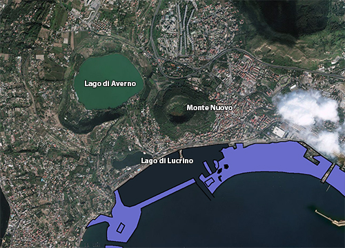
The realization of the new port with a limited infrastructure was carried out by the architect Lucio Cocceio Aucto. In antiquity the harbour was protected by a long, narrow on the beach built dike, which started at the Punta dell’Epitaffio and ended at Punta Caruso where it crossed the via Herculanea. In the dike was a canal through which ships could enter the outer harbour, the Lucrino basin. From there, through another canal you could enter the second basin, the Averno basin.
The port was home to the Western Mediterranean See fleet, the classis Mensinensis. The Eastern fleet took up residence at Ravenna.
The military port of Misenum
The port of Misenum, with the same shape as the port of Ravenna, was located next to the present Bacoli and namesake Capo Miseno. Like Ravenna, this port could house at least 250 vessels. When the port of Julius became impractically as a military harbour during the Augustan period, they chose for the nearby port of Misenum as successor. Misenum became the base of the Praetorian fleet guarding the western part of the Mediterranean Sea.
A fast decline, in favour of Misenum
The military life of Portus Iulius was very short. Probably already in 12 AD, by silting up, the harbour became impractically and the military fleet was moved to the nearby port of Misenum as we said before. The port of Julius was converted into a civilian port. After the military period the area became, like Baiae, a place of luxurious residences and spa treatments.
In later centuries the port structures were at the fate of bradyseism. Cassiodorus tells us that at the end of the fifth century the breakwater of the port slumped down and was destroyed finally.
During the following centuries the whole dam and port structure disappeared under water and Lucrino became part of the sea. A document from 1503 in which various movements of bradyseism are described, says:”When the sea runs dry it shows several ‘pilae’.”
The raising of the coast phenomenon continued till the eruption of Mount Nuovo on 29 September 1538 which led to the disappearance of the village Tripergole and reduced Lake Lucrino into less than a water puddle.
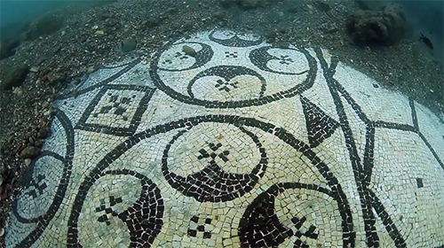
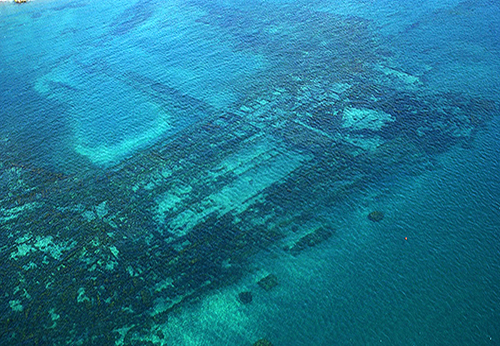
People started talking again about Port Julius at the end of the Second World War. Thanks to aerial photography and the first usable pictures made by pilots as well as to underwater photography. This has been an important instrument to the increased interest of students and the soprintendenza. The latter has, after watching the air photos, set the first steps to protect the area by starting a couple of dive campaigns with the aim of mapping the large port complex that should be covered an area of about 10 hectares. (zie video).
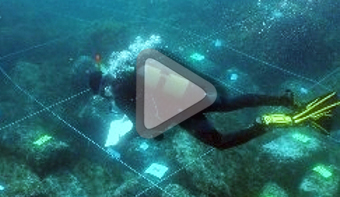
Up to today only the eastern part and specifically the part before the “Lido Augusto”,has been explored. This part consists of buildings, used as warehouses and built in walls of ‘opus reticulatum’ (small diamond shaped regular tuff stones), no higher than a few centimetres up to one meter above the sea bottom. These buildings were overlooking a central courtyard and bordered at the west side on a peristilium type country house with columns of bricks. The vast majority of the complex is not yet mapped. Today’s graphics come from photo interpretations.
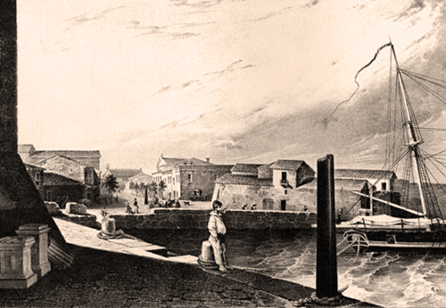
The original civil port of Baiae was, like Portus Iulius, equipped with a dike interrupted by a canal for entering or leaving the harbour. From the fifth century Baiae with its port went also down to the forces of nature. Finally due to malaria, over time, the whole region became completely desolated.
http://www.archeoflegrei.it/
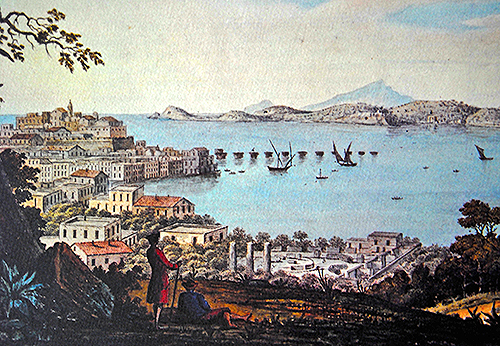
notes:- 1: Campi Phlegraei-Napels, drawing by Sir William Hamilton from1776
- 2: Trajanus built his harbour at Portus more inland, behind the harbour of Claudius. The latter was relatively open to the sea and caused much trouble by stormy wheather. Ships prished inside that harbour of Claudius.
- 3: opus pilarum vi maris conlapsum a divo patre suo promissum restituit. Translation: The by the force of the sea destroyed pillars restored according to the promise of his divine father
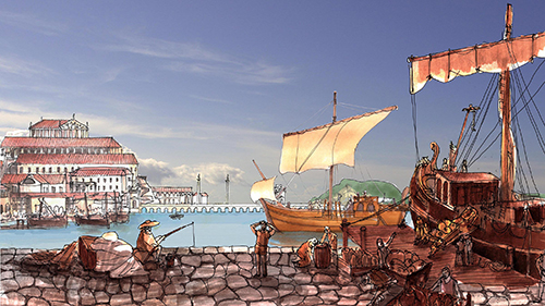
- 4: Artist impression made by Cristiano Fiorentino
- 5: Bradyseïsm is the gradual increase or decrease in a part of the earth’s surface by filling or emptying of underground magma chambers of a volcano
- 6: Photo: Ferdinando Marfella
- 7: Photo: Tower Life (Octavia Drughi)
- 8: Photo: Archivo Soprintendenza Speciale per i Beni Archeologici di Napoli e Pompei
- 9: Opus reticulatun: A by the Romans at about 100 BC development building system consisting of small diamond shape tuff stones.


 We are committed to providing versions of our articles and interviews in several languages, but our first language is English.