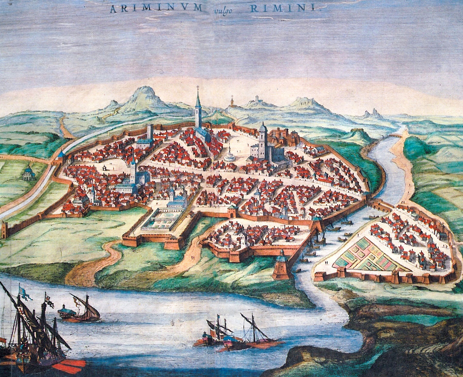
"Ariminum, like Ravenna1, is a settlement of the Umbrians, although each one is home to Roman settlers. And Ariminum has a port and a river of the same name." 2
In the above text, the Greek geographer, historian and philosopher Strabo, in his work‘Rerum Geographicarum’ from the early first century AD, tells us that Rimini in his day had a harbour and a river of the same name as the city.
Ariminum was founded by the Romans in 268 BC as the Latina Colonia Ariminum3, after the local tribes, the Umbri, were expelled during the Gallic War (285-280 BC). The city was strategically located on the shore of the Mare Superum (Adriatic Sea) between two rivers; to the north of the city the Ariminus (today's Marecchia) and to the south the Aprusa (today's Ausa), and was seen as a bastion against incursions from the sea by the Celts and at the same time as a springboard for the conquest of the Po plain.
the Rubicon.
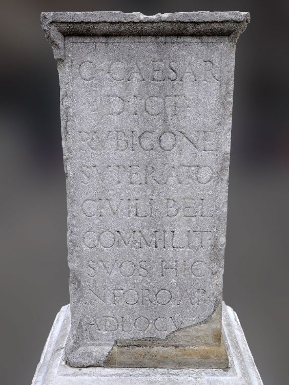
No doubt Ariminum was originally built as a fortified army town, a castrum, with a decumanus and cardo, with defensive walls, and the port will have been facilitated for the Roman war fleet. The city was therefore involved in the civil wars of the first century and joined the side that stood up for the common people, first Gaius Marius4 and later Julius Caesar. According to tradition, in 49 BC, after crossing the Rubicon river with his army5, Julius Caesar is said to have uttered his legendary words Alea iacta est, the die is cast 6, in front of his men on the forum of Ariminum.
The harbour
Not much is known about the exact location of Rimini's harbour and harbour structures during the Roman-period. Due to the silting up of the coastline caused by the southerly current and the supply of sediment from the various estuaries, the current coastline at Rimini is much more easterly than in Roman times.
According to Alessia Morigi7 the ancient harbour would have been located in the middle of the medieval urban coastline, a few metres from the mouths of the Ausa and Marrechia rivers. To get an idea of what the port might have looked like, you can look at the city's infrastructure at the time of its foundation.
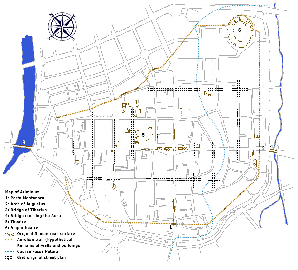
The main clues come from the trace of the wall and the organisation of the road network. Defensively, the city lay protected between the two waterways of the Marecchia and the Ausu, but soon received the additional protection of a surrounding wall to complement the natural protection provided by the coastline and the course of the Marecchia.
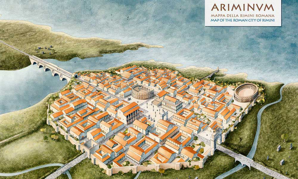
The most recent data on the original shape of the city outline a primitive enclosure with a dating consistent with the foundations found and a layout with a perfectly rectilinear development. The street plan, which even in the first phase was regularly laid out with rectangular blocks of houses, had two access roads, the Cardo, towards the coast and the Decumanus, perpendicular to it towards the hinterland.
Since the Cardo was originally perpendicular to the coast, we may assume that a harbour was planned from the time the settlement was built. At a later stage, the Decumanus was bent over and came to run along the coast. According to scholars, this reversal can be dated to the first half of the second century BC and attributed to the opening of the Via Flaminia and the Via Emilia8.
Harbour infrastructure and facilities
Since archaeological documentation on the location, form and chronology of the harbour structures is lacking, we have to rely on written traditions of the disappeared structures.
Following a chronological order, the first clues are due to ancient authors, who incidentally limit themselves to brief mentions of 'a port with the same name as the river'10 and the repeated military use of the port from Republican times11 to the threshold of the Middle Ages12.
We have more to gain from the records of the reuse of material from the ancient harbour in later centuries such as in the construction of the 'Maletesta Temple'13
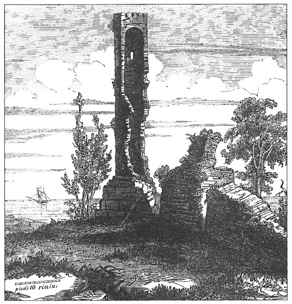
Of the episode of the collapse, Antonio Bianchi's testimony is preserved:
"The tower was made of bricks, based on a pier of marble well connected with a large amount of lead, which ended in a sharp corner, whose two outer sides beyond the base of the tower were five feet long. The tower measured six feet on each side and was seven feet high. After the collapse of the tower, the pier was also demolished, from which a quantity of marble was extracted to a certain depth; and so, even of this monument, which certainly should have been preserved, little remains but the foundations, which could not be raised because of the constantly rising water".14.
The dimensions indicated by Bianchi match those noted by Pietro Santi in the margin of his sketch of the tower: "Fanale dell'antico porto" in the state in which the tower, believed to be the lighthouse of Rimini's ancient port, was found shortly before its fall. Its height was found to be thirty-seven feet. The ruins were about half a mile from the sea and slightly less from the city15. As for the alleged old pier, if municipal engineer Gaetano Urbani is to be believed, its remains were still visible in 1873: "Wall built on the ruins of the old pier. Occupation of municipal property by Serafino Gaddini". Researchers basically agree, at the moment, that the dam of the ancient port lies under the square of the current station.
The mosaic of Rimini
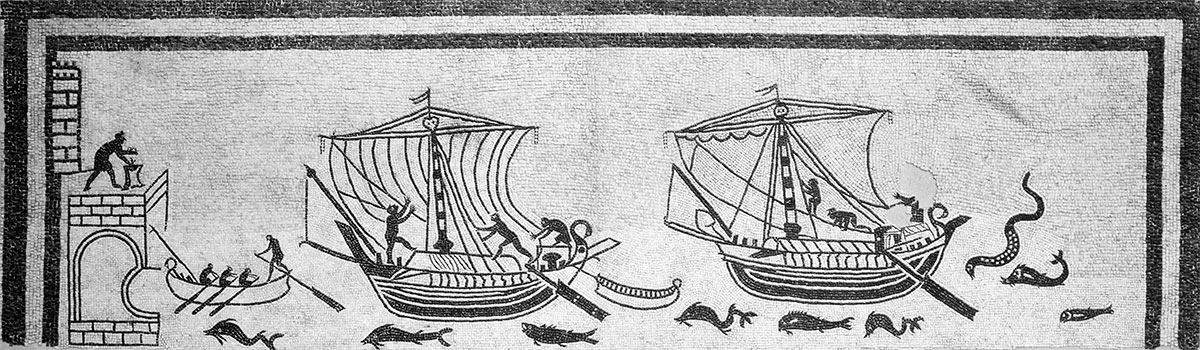
Traditionally, the ancient port is associated with a mosaic from the second half of the 2nd century AD, found in Rimini (see Figure 6).
The black-and-white mosaic shows a facade of a tall tower with battlements with a platform in front of it with a gallery from which one has a good view of a harbour. The platform is clearly meant for the person responsible for the fire burning there. Perhaps we are looking at a lighthouse here. The wall with battlements, built in opus quadratum (large blocks of tuff) will then have to represent the city wall.
The entrance to the harbour is blocked by two merchant ships and a small rowing boat. The cargo ships have a rostral prow (heavy beam at the front) and a curved stern with an anserculum (goose neck) as decoration.
Incidentally, the connection between the ancient port of Ariminum and the mosaic is rather tenuous and should therefore be seen as a stylistic representation of the port.
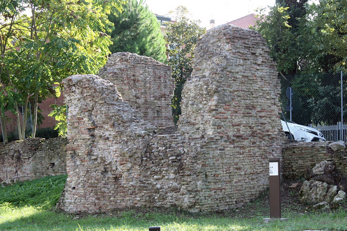
Rimini's oldest port
lighthouse.
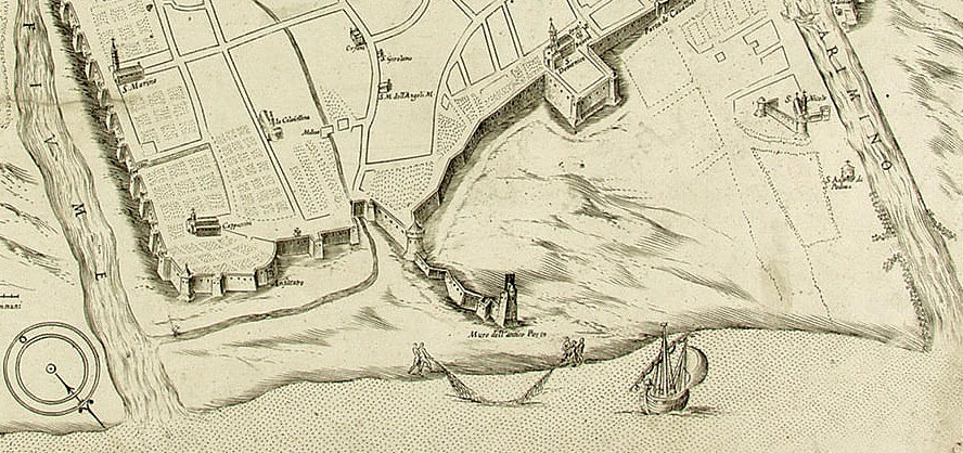
This Roman quay, which closed off the large harbour basin on the eastern side, was built in opus quadratum with large blocks of stone, possibly trachyte, held together by lead staples. It has been established that that quay was at the level of what is now Piazza Martiri d'Ungheria and described a wide, inward-running arch (see figures 7 and 8).
At the end of the front section stood the Farea tower. This tower, probably from the 10th century, is said to have been built on the foundations of the original Roman lighthouse, even before the Roman port was silted up.
Between the city wall and this tower, it was possible to reconstruct the course of the old harbour dam.
The harbour dam was built using stacked stone blocks in steps. Presumably, the entire harbour was constructed in an analogous manner at a later stage.
Little is known about the harbour structures and functions. No traces of a harbour structure have been found along the ancient coastal inlet between the Marecchia and the amphitheatre. However, based on written sources, a warehouse complex, the Horreum Pupianum, was reported near the Santa Maria al Mare18. The horreum was located near the port outside the city wall.
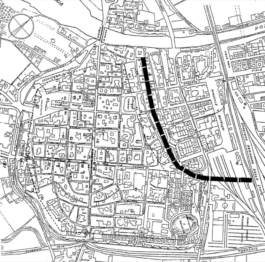
Yet from the beginning, the port must have played an important role in the choice of the colonia's location. Research at the end of the last century showed that today's Via Clodia roughly follows the course of the ancient harbour basin (see Figure 8).
North of the city, a whole network of drainage canals had been constructed to drain the surrounding marshes. The drainage and cloaca Maxima (the main sewer) of Ariminum were also connected to this system, which gradually grew into a system of navigable canals, the fossae Patara, extending deep into the Po plain.
From the third century, according to Alessia Morigi, silting shifted activities more towards the inlet of the Marecchia19. However, as the port would have been in use until the Carolingian period, a second port does not seem likely. The harbour must have been well maintained for a long time. It is possible, however, that a smaller quay was placed on the Marecchia.
The construction of a new medieval lighthouse also shows that the port must have been in use for a long time.
Did Ariminum have two seaports?
According to late antique authors, the port of Ariminum clearly had a military function. When the Emperor Augustus placed one of his two fleet bases (the Classis Ravenna) in the neighbouring city of Ravenna, Ariminum lost its military importance and turned into a trading port.
There is, as I mentioned earlier, very little tangible evidence of the ancient city and altogether of the port and its structures. Therefore, one knows almost nothing for sure about the port facilities, quays and warehouses.
which Clementini says entire fleets could moor there.
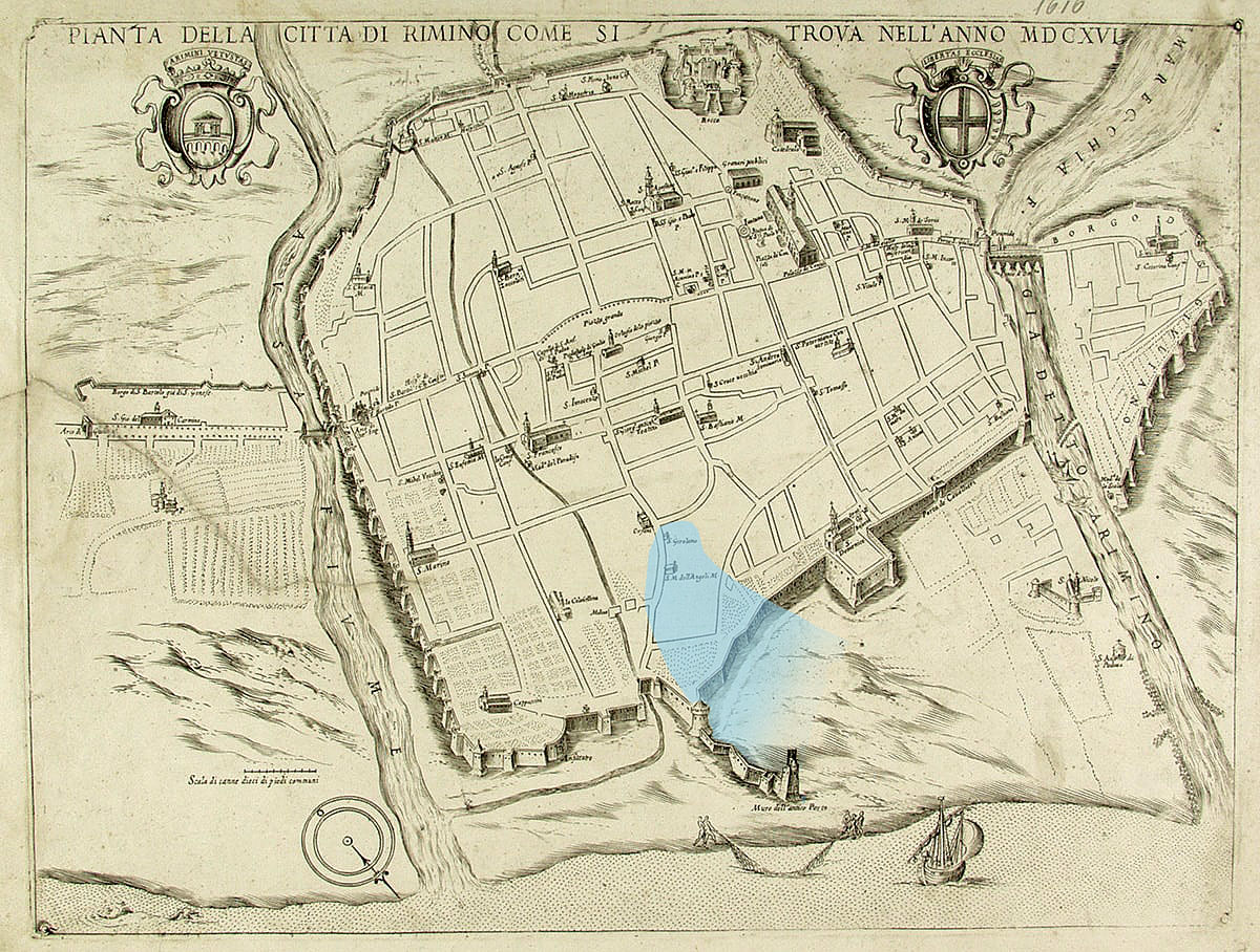
In 1617, one Cesare Clementini wrote about Rimini: “Haveva la Città due porti di Mare" (Does the city have two seaports?) He had several theories about it, which were gratefully followed by various scholars.
This second port would have been formed by an inlet that began at the Oratory of San Girolamo and reached the sea at the height of the current post office in Via Roma.
Prof Giovanni Rimondini, historian and writer, strongly contradicts this and wants to battle with counter-arguments in his publication “Rimini romana ha avuto due porti? Il falso “seno di mare” di Cesare Clementini” from 2019, with everyone.
On the place where the port should have been located, after silting up of the harbour, the city expanded considerably and any traces and foundations are deep under the current city. Unfortunately, the same applies to Rimini as to several other ancient cities, such as Marseille20, for example, which have continuously expanded over the past 20 centuries, literally and figuratively burying the interest and remnants of its cultural heritage. Fortunately, some scientists and archaeologists can always be found willing to dedicate themselves to the knowledge and preservation of the legacy of ancient cities. Thus, the aforementioned Professor Giovanni Rimondini not only refuted the, in his view, erroneous theory of Rimini's two seaports, but also started an in-depth study of the Roman walls in the sea area and other remnants of Rimini's historic centre some years ago. We are talking here, as far as the Roman period is concerned, about the Amphitheatre, the first Roman walls, the exit of the Fossa Patara and the imperial Roman walls from the 3rd century AD. We leave the research on later periods out of consideration here for the time being.
Of course, we cannot speak of one unchanging layout of the city like, for example, the regular street plan of Ariminum. Many changes will undoubtedly have taken place over the various Roman centuries.
The archaeologist Mario Zuffa (1917-1979), based on the probable remains of a Roman tower in Via Giordano Bruno, examined the hypothesis of Roman sea walls not far from Corso d'Augusto. He also noted that at the time of the construction of the Arch of Augustus on the south side of the Decumanus, more than two centuries after the city's foundation, the primitive walls of Ariminum must have been in a poor state: largely abandoned or demolished to extract material and even partly replaced by buildings, which recent excavations have confirmed.
The arch itself was built as an open gate because there was no need for defences during the Pax Romana, the long period of peace during the reign of Augustus.
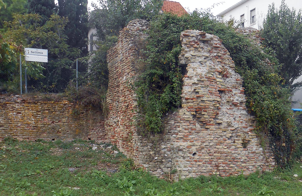
Between 1915 and 1995, the first Roman sea walls of Ariminum were recovered. A certain Vittorio Belli (Rimini 1870 - 1953) pointed out a particular section of wall to Giuseppe Gerola, the first superintendent of monuments in Romagna, in the summer of 1915. After looking at the wall, the latter wrote the following letter to his colleague in charge of archaeology in Bologna:
"When I went to Rimini this morning, I was able to examine the surrounding wall that runs from the Roman amphitheatre, along the north side of the city, to the railway station. In the past, plants and other obstacles made it impossible to examine it, and now my attention has been drawn to it by Dr [Vittorio] Belli, who follows his city's archaeological finds with great passion. Contrary to what I thought, the original city wall dates almost entirely from Roman times - albeit in decay. In the Middle Ages, it was repaired in only a few places and almost completely re-plastered. Along the course of the walls, you can admire the remains of a double-ring brick gate, which is very similar to the construction of the Amphitheatre, and further along, a certain arch under which a watercourse runs; here, too, is a niche carved into the wall, which you would say was intended for a statue. Well, since this part of the wall has not been notified, or rather it has been explicitly agreed in the past that it could be demolished, and, moreover, concrete trenches and other excavations and earthworks are being built in front of it, I would consider it very opportune for Your Lordship to visit it immediately, so that You can take whatever measures You deem most appropriate."
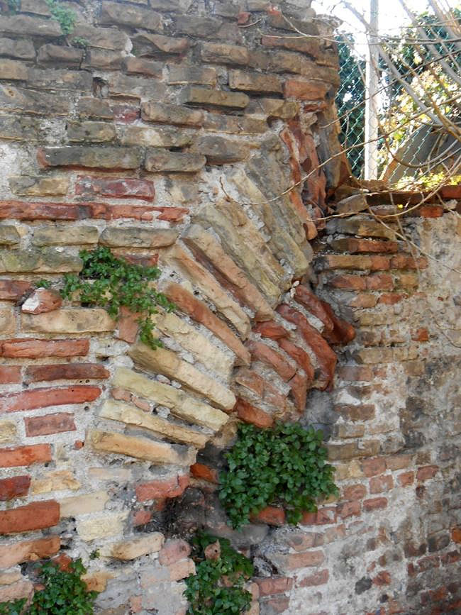
According to a hypothesis by Professor Rimondini, which is not (yet) supported by archaeological evidence, three or four layers could be identified in the remains of the sea wall we still see today.
- The upper layer (the largest surface) is the so-called Malatesta wall (15th century) 23.
- This is followed by the third (or second, if there are no republican foundations underneath), a Roman layer, which is dated to the 3rd century AD - during the time of emperor Aurelianus who reigned from 270 to 275. This layer is said to be characterised by an often 'messy' structure, made in great haste and composed of pieces of Roman brick and roof tiles containing other pieces of stone and even fragments of marble. In contrast, there are also regular pieces of masonry.
- Underneath, regular structures composed of sesquipedale 24 or manubrate 25 bricks. These types of ordered structures correspond to those on either side of the Arch of Augustus, which were founded on a primitive polygonal base of sandstone from the Covignano region. Consequently, these walls and towers could also date from the time of Augustus or even from the time of the first Roman residential community from 268 BC.
There are several reasons, according to Professor Rimondini, to consider these seawalls as the first of the Roman defences of Ariminum:
- they have an ordered geometric shape perfectly parallel to the Decumanus,
- the towers are almost certainly located at the end of the enclosures,
- the thickness (about 3 metres) is the same as that of the walls on either side of the Arch of Augustus,
- the two towers of the seawall possess the same architectural structure that can be seen today in the two towers on either side of the Arch of Augustus and in the first tower upstream of the Arch excavated in 1987.
Perhaps in the future it will be possible to carry out more extensive and deeper ground surveys of the original port and city from Roman times.
Even of the major monuments, only a few remain that we would like to mention here anyway:
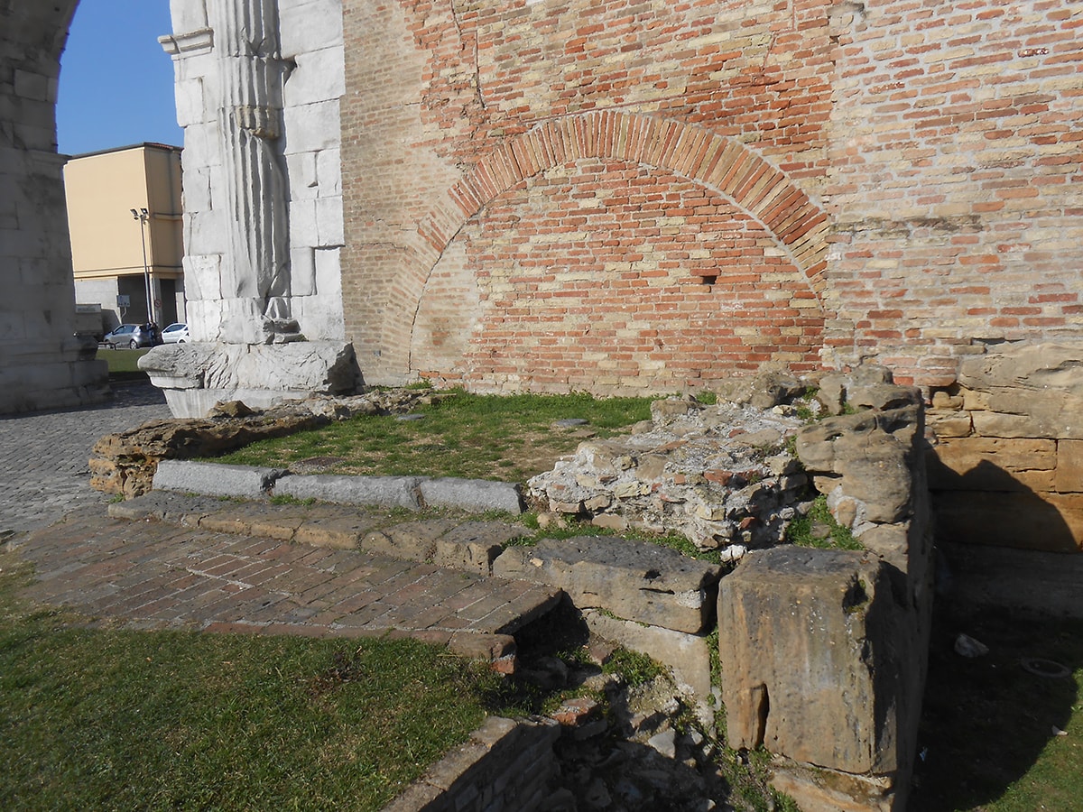
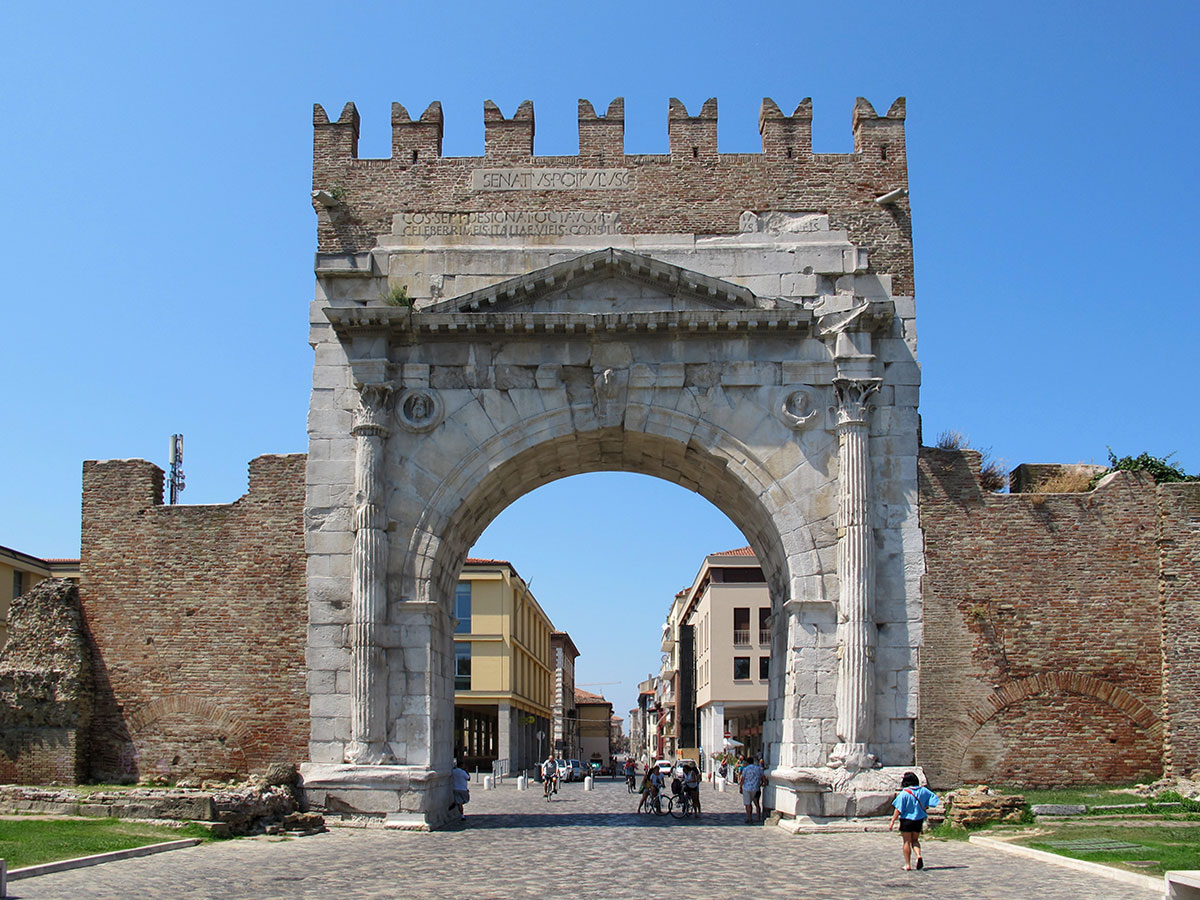
Arch of Augustus.
This open gate from 27 BC, located at one end of the Decumanus, is the gateway to the city coming from the via Flaminia, the ancient road that connected Ariminum to Rome.
The gate was built in honour of Caesar Octavian Augustus and is the best-preserved city gate in northern Italy. The gate is about 17 metres high and 4 metres deep and, as already mentioned, has a wide arch without doors. It is made of stone from Istria. On the sides, the gate has half-columns with Corinthian capitals and projecting discs with the effigies of Jupiter, Apollo, Neptune and the Goddess Minerva. Also depicted were ox heads, symbolising Ariminum as a Roman colony.
Originally a statue of Augustus was placed atop the gate. The gate is supported by remnants of the old city wall and towers.
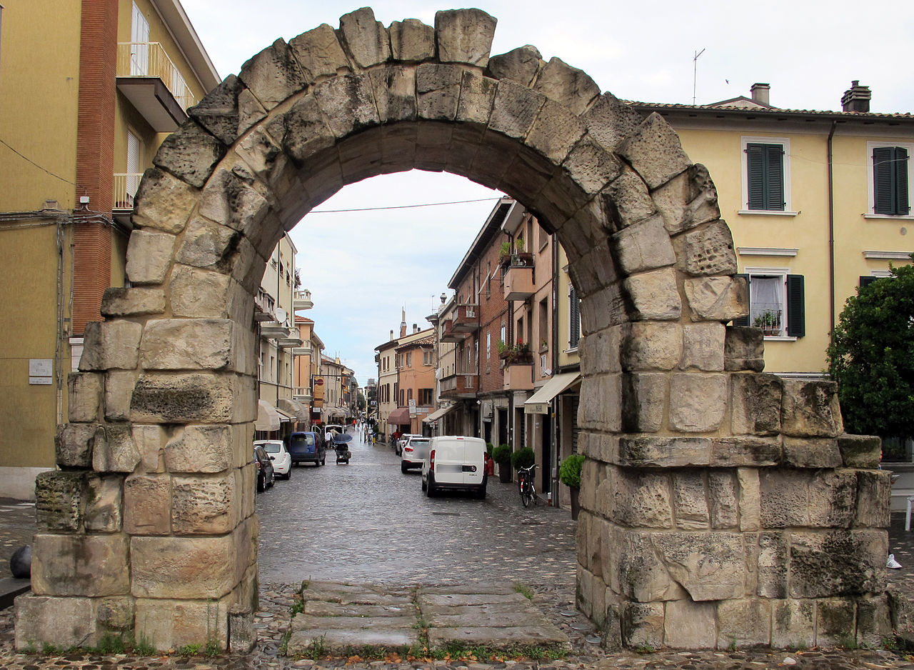
This Roman gate, smaller than the Arch of Augustus, was the gateway for those coming from the Marecchia Valley along the Via Aretina. Its construction dates back to the 1st century BC, when Sulla29 redesigned the city's defence and wall system. Today, this gate stands at the end of Via Garibaldi and looks like a round arch in sandstone, but that is only one of the original two parts of the ancient gate.
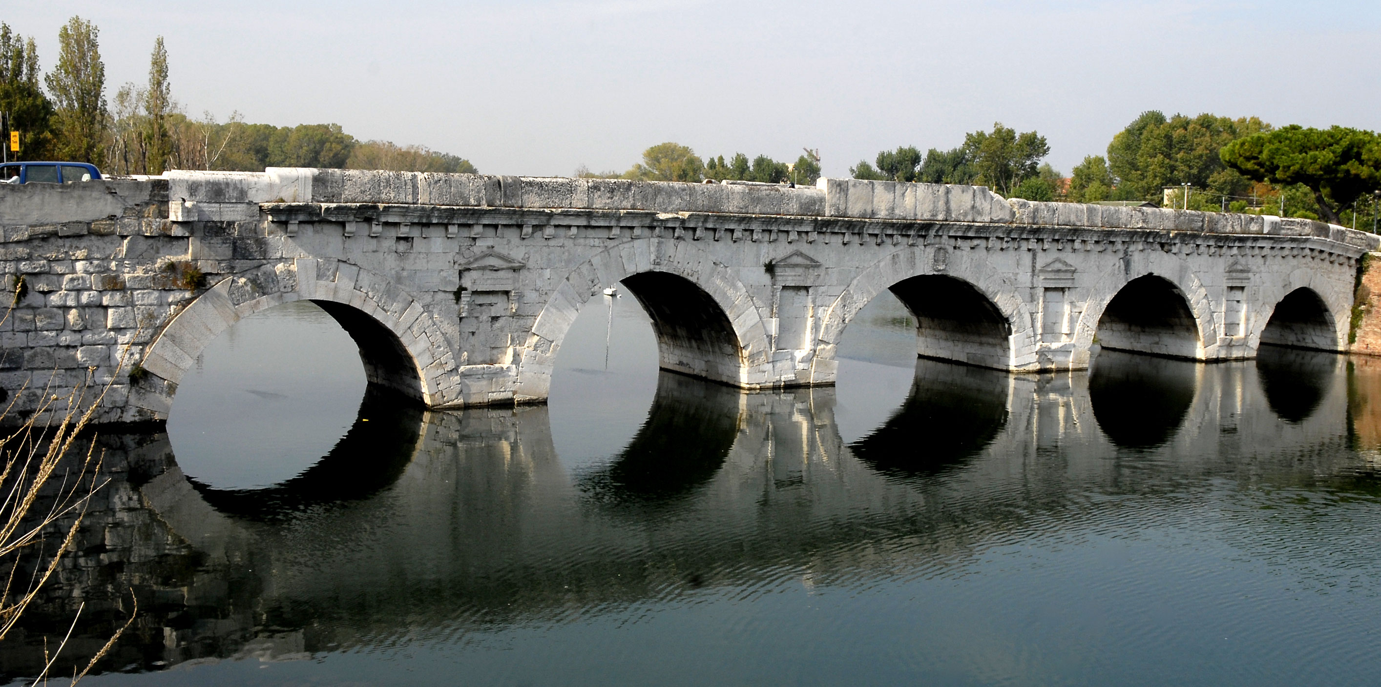
Bridge of Tiberius
The Tiberius Bridge is one of Rimini's most famous monuments. Built between 14 and 21 AD in honour of the emperors Augustus and Tiberius, it was indispensable for crossing the Marecchia river, which once flowed into the channel's harbour basin.
It is the starting point of the Via Emilia and the Via Popilia and made of Istrian stone with five arches of different sizes and has an austere style but a remarkable technical function.
It is also called 'pont de dievli' bridge of the devil, because on one of the walls are goat-like signs.
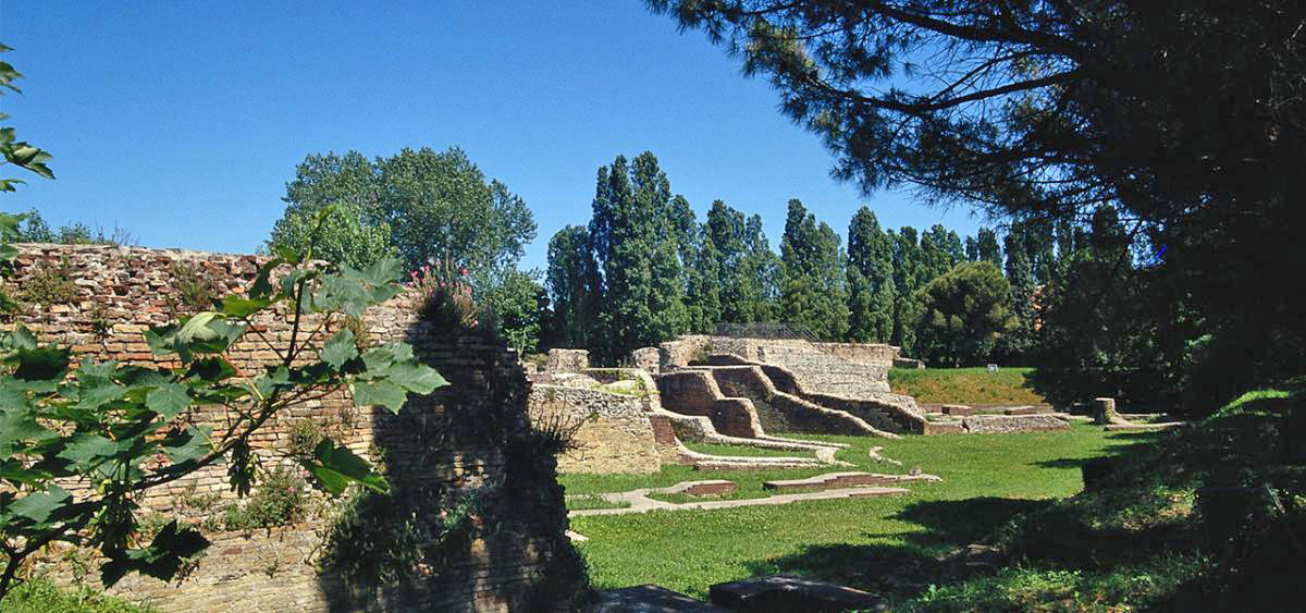
Amphitheatre
The Roman amphitheatre was built in the 2nd century AD by order of Emperor Hadrian, to provide the city with moments of entertainment and relieve social tensions according to the custom of panem et circensem. The building stood far from the centre and originally outside the city walls, a stone's throw from the sea and the ancient Roman harbour.
The theatre was elliptical in shape, 118 m by 88 m, and the dimensions of the arena approached those of the Colosseum (73×44 m). Mainly gladiatorial fights took place here. The theatre probably accommodated 10 -12,000 visitors.
In the late imperial period, the city walls were extended and the amphitheatre came to lie within the walls.
In the Middle Ages, large parts were demolished and its materials reused for other buildings. Today, only a few remnants remain: pieces of terrace, steps, glimpses of arches and perimeter walls. The building was rediscovered in 1843 by the historian Luigi Tonini.
- Source
- - A. Morigi: Città e Nonumenti Nell italia antica - sul più antico porto di rimini (1998)
- - Stefan Decraemer: De Romeinse havensteden van het noordelijk Adriaticum, Ariminum (Rimini) 2007/2008
- - Valentina Lepore: ITINERARIO: LA RIMINI ROMANA
- - Giovanni Rimondini: Alla riscoperta delle mura romane sconosciute a mare di Rimini tra via Settimia e via Roma (2019)
- - Giovanni Rimondini: Rimini romana ha avuto due porti? Il falso “seno di mare” di Cesare Clementini (2019)
- - Wikipedia
notes- 1:Read for Ravenna our article 'Roman Military Ports'
- 2: Strabo, Geogr, 5, 1 – (Geographica)
- 3: A Roman colony consisted only of Roman citizens with all the rights of a Roman; a Latin colony was a community of Latins and Romans with fewer rights.
- 4: Roman army commander and statesman. (175-86 BC). Made the army a professional army with social rights including contracts for payments and pensions.
- 5: At the Rubicon, the demilitarised zone began as far as Rome. By law, armies were forbidden to cross this border.
- 6: Suetonius, Divus Iulius 32f.
- 7: Alessia Morigi – PhD in topography of ancient Italy associated with the University of Bologna and the University of Naples.
- 8: Giorgetti 1980, scheda 2; Sommella 1988 p. 215
- 9: Photo: Riviera Romagnola
- 10: Strabo, Geogr, 5, 1 – (Geographica)
- 11: During the second Punic War, the consul T. Sempronius Longus brought the army overseas from Sicily to Rimini. ( Liv. XXI,5,7).
- 12: In the life of Archbishop John, Agnello relates that in 491 AD, Theodoric the Great departed from the port of Rimini for the siege of Ravenna, while the Soratian Chronicle recalls Charlemagne's decision to equip the ports of Aquileia, Ravenna, Rimini and Ancona. (TONINI 1864, p. 2).
- 13: Sigismondo Malatesta, lord of Rimini (1432 - 1468), had a classical cathedral built around 1450, which was called the Tempio Malatestiano. The cathedral was never completed.
- 14: TONINI 1864, p. 3; TONINI 1948, pp. 215 e.v.
- 15: RIMONDINI 1996, p. 39.
- 16: Mosaic in Palazzo Diotallevi at Rimini. (Photo Frederico Ugolini).
- 17: Refer to Luigi Tonini's 1864 monograph.
- 18: For the hypothesis of a large mooring equipped with mooring and unloading berths and bounded towards the city by shops and warehouses, see GOBRT, Sica 1982, p. 23. The Horrerum Pupianum is said to have been built at the end of the 1st century BC by a certain C. Pupio Blasto, and according to tradition outside the ancient walls near the harbour, perhaps at the direction of Clementini, who pointed out the site in the block of S. Maria Ripa Maris, where a plaque has been found.
- 19: Morigi A. 1988, page 73-74
- 20: Read our article: Massilia, “La Cité Phocéenne"
- 21: Photo - Article Giovanni Rimondini
- 22: Foto - Article Giovanni Rimondini
- 23: See note 13.
- 24: Sesquipedale bricks = bricks with a length of 1 ½ Roman feet
- 25: Manubrate bricks = notched bricks
- 26: Photo - Article Giovanni Rimondini
- 27: Photo - Marcllo Cartoceti, Adarte.
- 28: Photo - Sailko (Wikipedia)
- 29: Lucius Cornelius Sulla (ca. 138 – 78 v.Chr.), a Roman politician, general and dictator during the Late Roman Republic.
- 30: Photo - Sailko (Wikipedia)
- 31: Photo - Heiko Trurnit
- 32: Photo - https://www.visitrimini.com/


 We are committed to providing versions of our articles and interviews in several languages, but our first language is English.