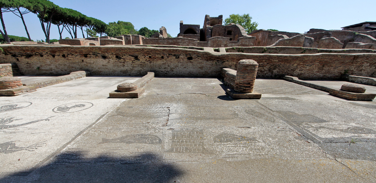
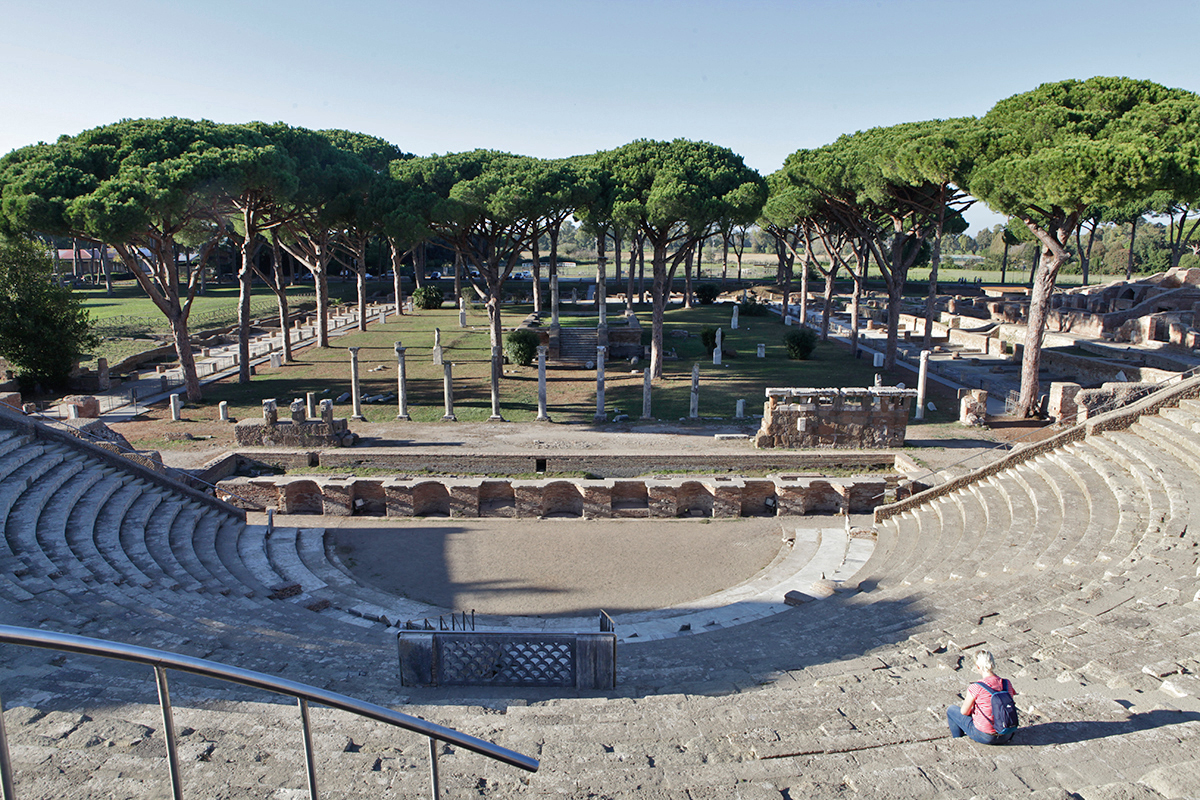
Every year hundreds of thousands of people visit Ostia, the ancient port city of Rome. One of the most striking buildings on this excavation is the theater with behind it the so-called "square of the corporations", a colonnaded promenade to which, from the end of the second century AD, 61 sales representatives were established1. The mosaic floors often depict the country, city or product that was represented. For many visitors it is a sport to discover the place or product: grain from Sardinia, wild animals for the circus from Africa or wine and dates from Mauritania.
Although most mosaics have been cleaned and restored a few years ago, this does not (yet) apply to every office. For example, Statio 10, according to the mosaic (NAVICULARI MISUENSES HIC2), was a representative from Misua.
This name will not be familiar to almost all visitors and, because the very interesting representation in the mosaic, is becoming less and less visible, it is not a place for many to dwell on for a long time and Misua (present-day Sidi Daoud in Tunisia), once an important Roman port, threatens to sink into obscurity.
In January 2021, a group of volunteers from the area around the former Misua started a campaign to bring the old Roman port city back into the light and to give it, based on its past, the attention it deserves.
Foundation Roman Ports and Misua
When we started in 2016, we made a choice of the most important Roman ports from the hundreds of more or less well-known ports3. This first list also included the port of Misua, although we also had no idea what this port was all about.
Recently we were alerted by Rami Trabelsi, a member of the Roman Ports Facebook group, about this initiative from Tunisia. This also prompted us to pay more attention to Misua. Although, as far as I know, not much research has been done yet, we found a French account of the research of a local diver and researcher , Soumaya Trabelsi. Her report, in which our friendly advisor, the Dutch/French harbour technical engineer Arthur de Graauw, also contributed, forms the basis for what we can tell you about this port.
Recent underwater discoveries (based on a report by Soumaya Trabelsi)
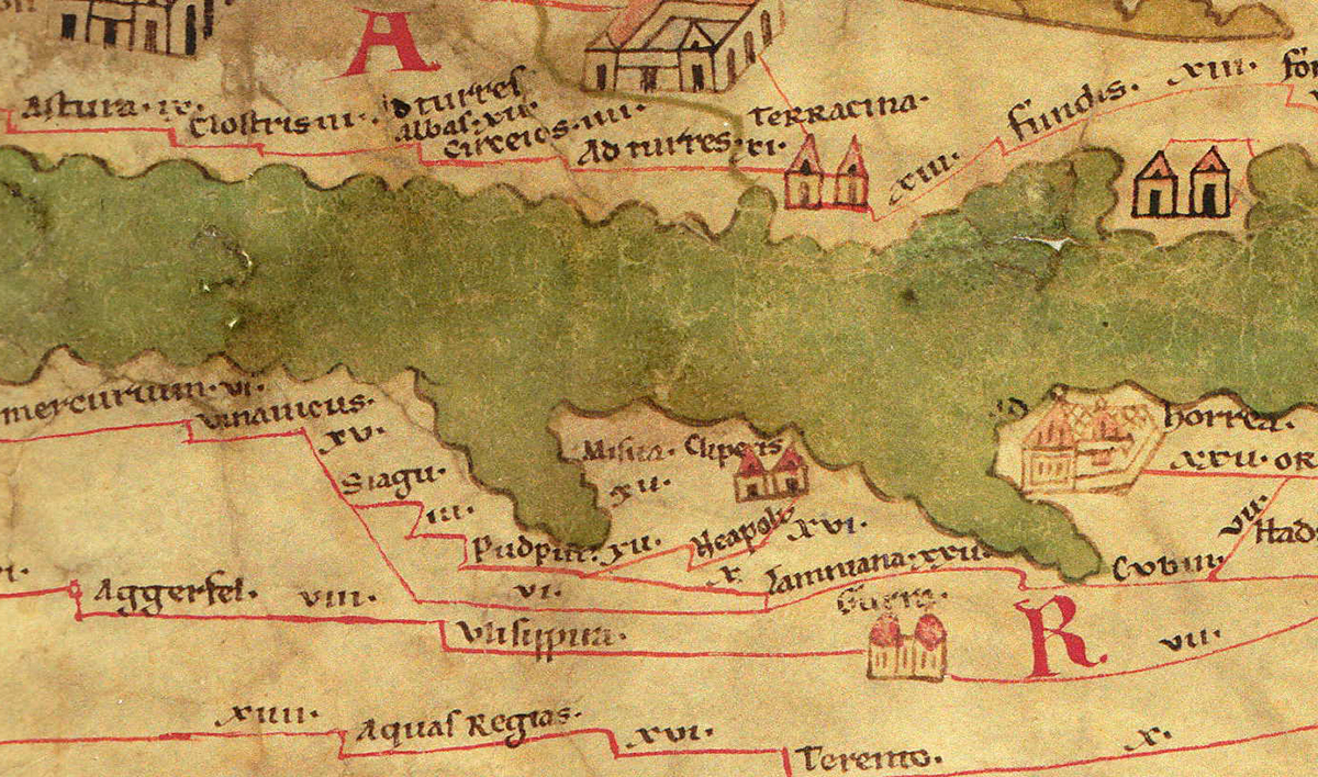
The fact that this Roman port is no longer so well-known is partly due to our lack of sources. Misua, which was located on the site of present-day Sidi Daoud, was mentioned on the Peutingermap4 and was represented in Ostia, but otherwise the traditions are scarce.
The city was located at the northeastern end of the Tunisian Cape Bon peninsula which was part of the Roman province of Africa Proconsularis. Misua is also mentioned on the base of a late Roman statue that the citizens of Misua erected in honor of their patron Flavius Arpagius:
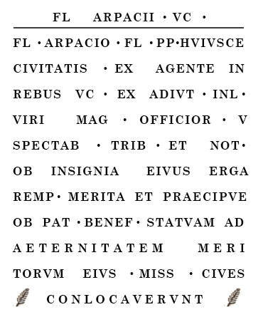
Translation:
[Sculpture of] the eminent man, Flavius Arpagius. To Flavius Arpagius, lifelong priest of this city, formerly excellent representative of the emperor, former illustrious assistant to the head of the offices, tribune and notary of distinction. For his remarkable service to the community, and especially his merits as a patron, the inhabitants of Misua placed [this] statue as an eternal reminder of his merits.
At first glance, hardly anything can be found of the ancient city and the original harbour.
However, in the past two decades, ancient ports have once again attracted the attention of archaeological and geo-archaeological researchers. Similarly, the old port of Misua.
The present situation
The port of Sidi Daoud is located on the north-east side of the Cap Bon peninsula. The promontory of Sidi Daoud is located more than 2 km southwest of the current fishing port which now bears the same name but was formerly called Thonara.
The current coastline is characterized by inlets and sea-jutting promontories that provide relatively poorly sheltered anchorages. A large area here has a depth of less than 5 meters.
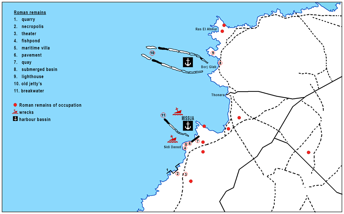
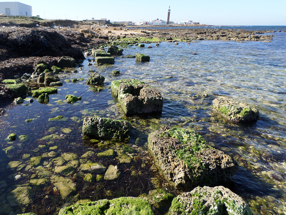
At 500 meters south of the promontory of Sidi Daoud we find old quarries today laying under water (1). There is still a fishpond on the promontory (4). A little north of Sidi Daoud we find another pier with a Roman quay (7).
To the north of the current fishing port of Sidi Daoud-Thonara is an inlet where old piers were discovered during the investigation (10) and finally an east-west oriented rock was found to the south of the promontory, which probably served as a protective dike for the main bay (11).
Research into the formerly coast in which the ports were situated.
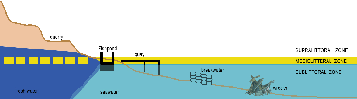
To gain insight into what the coast looked like in Roman times, it is important to find out how high the water level was. Misua had, among other things, a large fishing industry. For this purpose, fish farming ponds were created that now allow us to reconstruct variations in sea level on the coast.
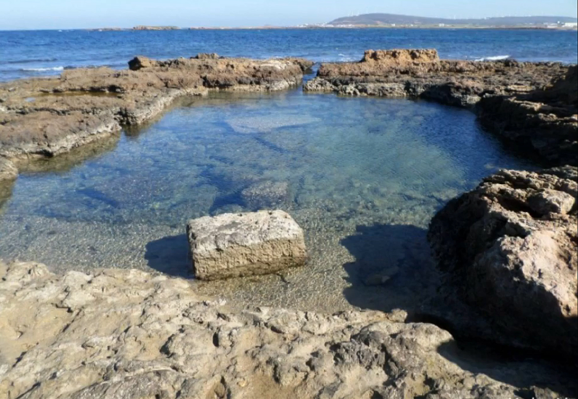
The fish-pond on the promontory of Sidi Daoud (4) was made in an old quarry. The pond has a circumference of 9.6 x 7.7 meters and the depth varies from 1.10 to 1.30 meters (see figure 7).
The reservoir has two channels connected to the sea that are now partly submerged. From the current water level and the traces of a lock including notches that can still be seen, it can be deduced that, compared to 1800 ago, there has been a slight rise in sea level of about 20 cm6.
In addition to research into the fish pond, probes were also placed along the coast to map the silted up sediment of the past 2000.
The first two drilling points were located in the southern part of Sidi Daoud near the flooded quarry and the ancient necropolis. The second point was on the beach at the height of the discovered quay wall. The last two drillings were done on the beach at the modern harbour of Sidi Daoud. Various laboratory analyzes were made of the sediment, including three radiocarbon dates on charcoal found at the foot of the fourth borehole. The dating came to an age of about 2380.
According to the research, the environment where drilling four took place, near the modern harbour, is characterized by a rather closed lagoon environment from about 2500 years ago.
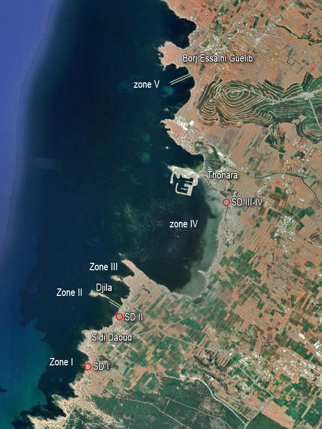
Underwater research on the port area of Misua has yielded an enormous wealth of archaeological finds, in particular due to the presence of port and urban dumps that extend over several hundred meters. In 2016, the expansion of the survey made it possible to uncover and zone five of them.
Zone I is located in the southern part where the now flooded quarries are located.
Zone II and III include the part of the site around the island of Djila.
Zone IV is located further north in the large bay to the south of the modern port of Sidi Daoud-Thonara.
Finally, Zone V is located near the village of Borj Essalhi Guelib.
Many archaeological finds have been made including some wrecks loaded with different types of amphorae, but also harbour structures. These were made of masonry around a body of stones. They could have been used as breakwaters against wind and waves, but also as a jetty for mooring ships.
The two wrecks of Misua lie at a depth of 8 meters. The amphorae found here came from Africa, Greece / Italy and Spain. They can be dated from the 1st century BC. until the fourth 4th century AD. Incidentally, little has been documented about the commercial history of this region. It turned out that the contents of the wrecks were found quite scattered. The reason for this will be the shallow depth, which means that the water column above the wrecks was not sufficient to protect them from the violence of the winter storms raging in Sidi Daoud.
The paleotopographic survey showed that the configuration of the coastline in Roman times was close to the current one, due to limited sedimentation since that time. We may therefore assume that during the development of the old port of Misua with its structures (zones I and II), the hydrodynamic conditions favored the construction of a port basin and the risk of silting was very limited.
In zones II and III, in a small bay, between the coast and the rocky island of Djila, a jetty-shaped structure is visible at sea at a distance of 100 meters from the beach. This structure is about 10 meters wide and lies 1 to 2 meters under water. It consists of two parallel rows of large stones arranged to cover a pier. The top surfaces are perpendicular or oblique by means of brackets connected together. Also, according to Davidson7, it could be seen as blocks surrounding an ancient fish-pond. However, the underwater surveys now done contradict Davidson's hypothesis and instead seem to indicate the presence of a pier, on which stood a wharf with a building that could have served as a lighthouse or beacon.
The antique remains on the land are numerous and should be seen as storage spaces. In this area, which was well protected from the waves from the North, the cargoes of ships with a great draft were unloaded and the goods were sent to the city.
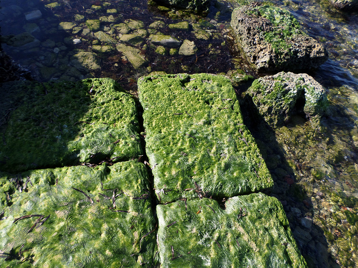
Research also made it possible to identify nearly cube-shaped blocks (0.50 m side) that demonstrate the continuity of a quay.
At the end of the quay, loose blocks were discovered along a great length, with traces of assembly still visible, such as holes for connecting studs, dovetails and lead deposits.
In the northern part of the Misua site (zone 5), two more parallel structures were found underwater, at a depth of 0.6 to 5.1 meters. The length was about 175 meters and the width 6 meters. Here too, two rows of large blocks had been placed to cover a pier. The southern part of the pier is deeper as it has likely subsided under its own weight.
This was undoubtedly a decent-sized Roman pier where several ships could moor at the same time. The construction materials used and the ceramic shards found at the beginning of the pier attest to the important commercial activity.
The pier was built as a single block of cement reinforced by a timber frame and lined with sandstone blocks. This masonry construction therefore differs from that of the south pier. This pier divided the bay into two parts and had a basin with a depth of 5 meters at the end. The structure is now under water.
Based on the building materials used, we can conclude that the northern pier was built after the southern one. Probably at the end of the second century AD. or at the beginning of the third century AD, so after the economic boom of the city. This northern basin was well protected from the waves coming from the north and provided sufficient draft for the large merchant ships, especially those of the Annona (grain supply for Rome). Afterall, a considerable area for anchoring, so that ships also had the opportunity to spend the winter here during the mare clausum8.
The function of the harbour
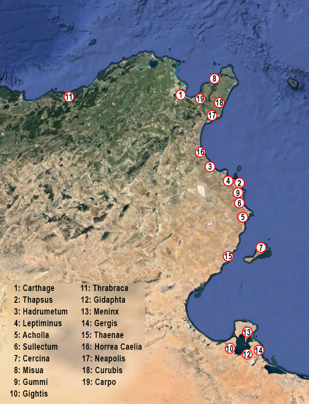
The African coast had a large number of Roman ports of various types. The largest, the African capital Carthage, was out of class.
In addition, there were large harbours with quays of 1,000 till 1,500 m in length, such as Hadrumetum and Thapsus. Another group of medium-sized ports had port structures with 500 m long quays, such as Leptiminus, Gidaphta, Acholla, Sullecthum and Cercina. These port facilities do not correspond to those usual in merchant ports. It is therefore difficult to assign them a function, especially because they are often not far from major ports.
Then there are the small harbours with quays ranging from 100 till 300 m, such as Misua, Gummi, Gightis, Thrabraca or Ruspina.
According to Aounallah9, the Cap Bon peninsula with its small ports occupies a special place when it comes to trade with Rome, because the journey from the Tunisian promontory to Rome was shorter. In fact, these ports were a stop between Byzacium10 and Italy.
The remains of port facilities of the sites of Meninx (El Kantara), Gergis? (Sidi Bou Teffaha), Gigthis, Thaenae, Acholla, Sullecthum, Thapus, Lepti Minus, Horrea Caelia, Neapolis, Curubis, Misua and Carpis are insufficient to characterize their place in the harbour hierarchy and their role in economic activity. Yet several of them had offices on the piazzale delle corporazioni in Ostia. At home, fields with amphorae and salt factories mark the former presence of a dynamic, industrial and commercial activity11.
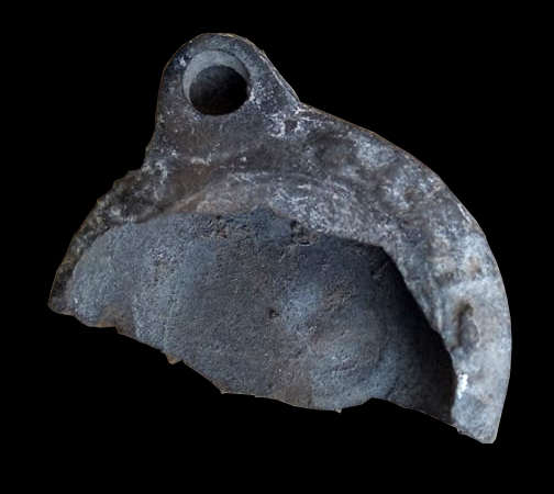
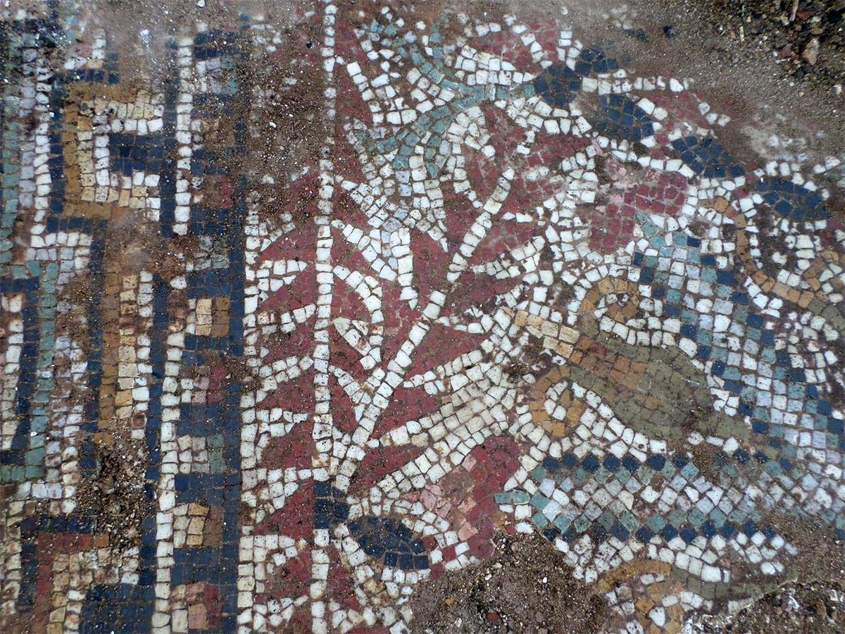
At Ostia, on the Piazzale behind the theater, were nine of the agencies from African ports. For example, the navicularii of Misua were mentioned (see Figures 1 and 2). The mosaic is richly decorated with two sailing boats, two dolphins and a tilted tower (or a grain bushel12).
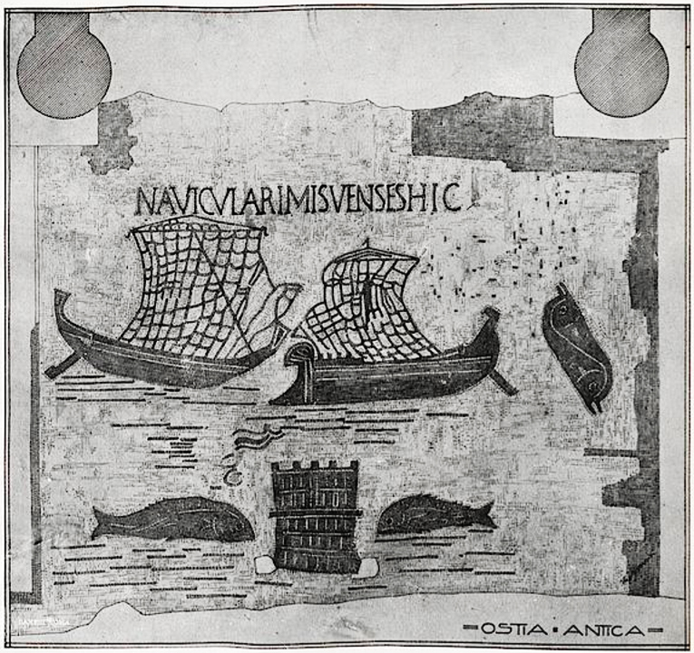
The name of Misua is also mentioned. Due to its location and the advantages of its port, Misua was therefore an interesting transhipment point for the transport of agricultural and traditional products from the hinterland of Cap Bon.
Other factors also played an important role, such as the growth of the fishing industry and the discovery of medicinal plants.
The appearance of the African amphora II around 150 AD. shows the emergence of a number of ports on the eastern North African coast from the middle of the 2nd century. The canned fish from the Tunisian coast was so successful on the Roman market that skippers did not hesitate to take them as part of the cargo. The port and trading city of Misua played an important role in this and would remain so until the 4th century. The harbour had at least two commercial basins with a lighthouse bordered by piers and a quay with magazines from which traces can still be seen.
Archaeological finds prove that from Hadrian's reign till the end of the 2nd century AD, the port of Misua was the center of a community of merchants and economic transactions. Until the middle of the third century, the number of warehouses grew steadily, especially when new products emerged. In particular, the production of preserves and food sauces was an important component of the economic development of the city and its immediate surroundings.
The city
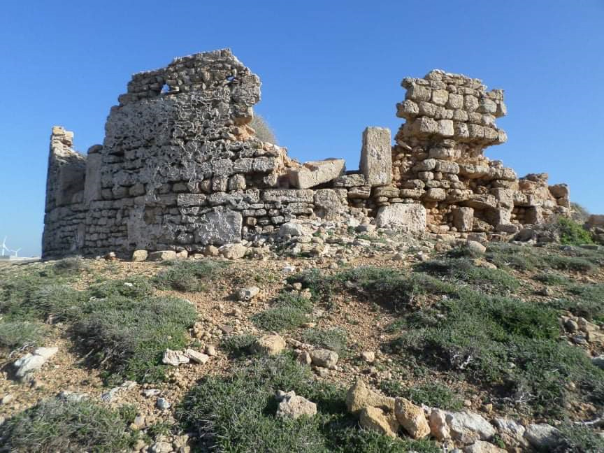
At the tip of the Sidi Daoud promontory we find an extensive site with important ruins, most of which are not very clear. Over a length of more than 20 meters on the cliff and on the water's edge, an alignment of blocks and a mass of blocks can be seen, emerging from beneath a modern ruined tower.
Closer to the point are other traces of large constructions, in between which a fragment of a mosaic has been preserved.
In the south of the site we find, over a length of 20 meters, a piece of paved road. This could have been part of an urban street plan. The paving consists of slabs of beautiful gray-blue limestone that must have been imported because the stone was unknown in Cap Bon.
On the right side of the pavement, along the water's edge, we see a small canal dug out of the rock. A short distance to the south, in the courtyard of a house, marble architectural elements have been preserved, probably from a Christian basilica.
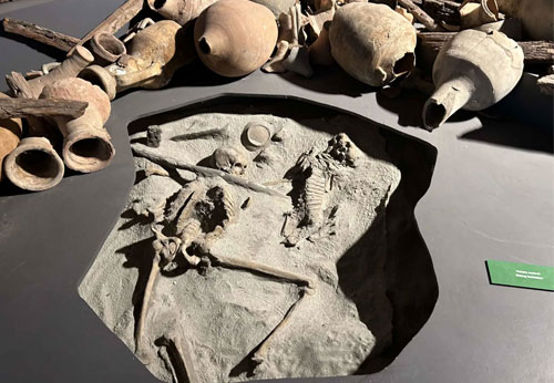
A short distance from the quarries are several necropolises with hundreds of graves. According to the researchers, this was “a burial place for humble people, probably inland workers and slaves employed in the quarries”. These graves show that the quarries must have been in use, especially in the first two centuries of the Empire, whereby it should be noted that the 63 oil lamps found there were almost all from that period and only one from them was also a Christian lamp.
We hope that this article can help raise awareness of this once-important Roman port of Misua and thus help the local organization in Sidi Daoud on its way to a revival of this ancient port city.
- Sources
- - The ancient harbor of Missua (Sidi Daoud). Recent submarine discoveries by Soumaya Trabelsi
- - SLIM, H. & TROUSSET, P. & PASKOFF, R. & OUESTLATI, A. (2004) « Le Littoral de la Tunisie », CNRS Editions, Paris.
- - Arthur de Graauw
Notes- 1: Read article: 'Overseas trade'
- 2: "The skippers (probably of grain) from Misua" present here
- 3: List of ports compiled from the University of Southampton list (PortusLimen) and the ports listed on the Piazzale delle Corporazioni in Ostia. Later supplemented with other ports)
- 4: The Tabula Peutingeriana or Peutingermap is a copy of a Roman travel map from the 3rd or 4th century AD.
- 5: Fl(avii) Arpagii v(iri) c(larissimi). / Fl(avio) Arpagio fl(amini) p(er)p(etuo) huiusce / civitatis, ex agente in / rebus, v(iro) c(larissimo) ex adiut(ore) inl(ustris) / viri mag(istri) officior(um), v(iro) / spectab(ili) trib(uno) et not(ario), / ob insignia eius erga / rem p(ublicam) merita et praecipue / ob pat(ronatus) benef(icia), statuam ad / aeternitatem meri/torum eius Miss(uenses) cives / conlocaverunt.
- 6: Andizei estimated the rise at 28 cm in 2005, while Slim also calculated an increase of 20 cm in 2004.
- 7: Davidson et al., 1992
- 8: Read article:’Winter shipping’
- 9: Aounallah 2001
- 10: Byzacena was a Roman province in what is now southern Tunisia
- 11: Callegarin, 2005
- 12: Chevallier, 1986
- 13: With thanks to Mr. Mohamed Bakara, director of the Youth House in Al-Hawaria


 We are committed to providing versions of our articles and interviews in several languages, but our first language is English.