Foreword by Gerard Huissen
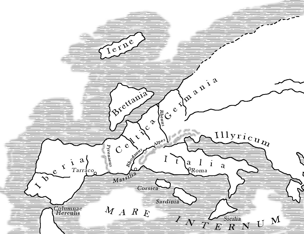
The Roman port city of Tarraco, modern Tarragona, was originally founded and inhabited by the Iberians. In the 2nd century BC, during the Second Punic War, the city came into the hands of the Romans and was given the name Colonia Iulia Urbs Triumphalis Tarraco, abbreviated Tarraco. It became the capital of the former province of Hispania Tarraconensis, which encompassed much of today's Spain.
In mid-2019, Patricia Terrado Ortuño published a voluminous investigation (362 pages) in Spanish about the port city that was so important to the Romans. Well, I suspect that many of you do not read Spanish and therefor, despite my lack of knowledge of the Spanish language, I promised to make an attempt to write an English extract understandable to our readers.
Patricia has given a very interesting and comprehensive handbook to the world in which she not only described all knowledge and sources of that knowledge of Roman Tarragona but also about concepts such as ports, shipping and trade from that time (2nd century BC - 3rd century AD Chr.) as well as other relevant matters.
The book as a whole is too in-depth for one article and I will therefore undoubtedly, at a later date, distil a second article from this complete manual on Tarraco. If you are able to read the Spanish book of Patricia, here you can download the original pdf: El Puerto de Tarraco and época Romana.
TARRAGONA
by Patricia Terrado Ortuño
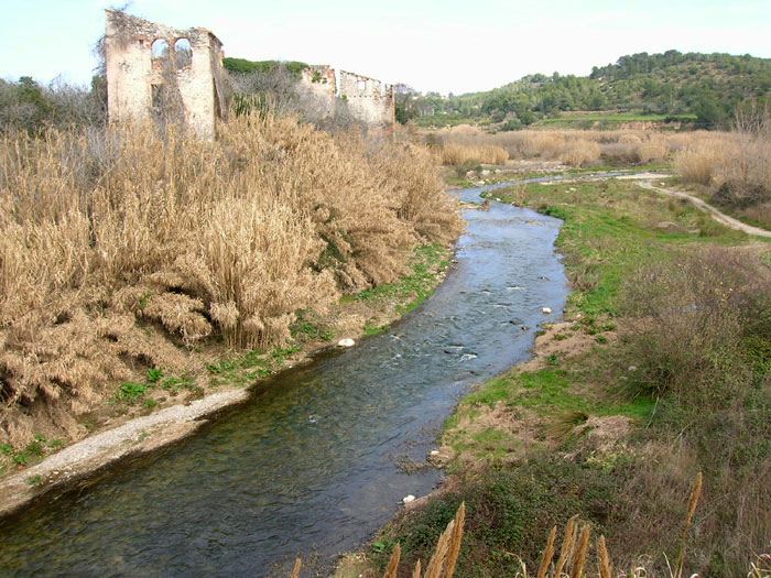
The history of the city of Tarragona is the history of the port. The current port of Tarragona is determined by the relief of the city that was traditionally located on an oppidium (fortified hill), with at its foot the mouth of the meandering River Francolí that flows into the Mediterranean Sea.
The Romans called the city Tarraco and after the fall of the West Roman Empire the city came into the hands of the Visigoths who called it Terracona. With the arrival of the Arabs in the year 713, it was gradually abandoned, after which the ruins remained the living place for only a handfull of inhabitants for four centuries.
After four centuries without dredging and maintenance, the abandoned harbour basin was largely silted up by the periodic supply of sediment from the Francolí river.
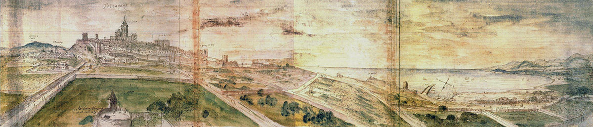
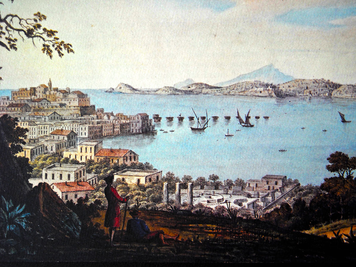
To see in what condition the port was at that time we have to look at the oldest preserved painting of the Renaissance city of Tarragona, made in 1563 by the Flemish painter Van den Wyngaerde (see fig. 1). The engraving shows the former harbour basin seized by fields, orchards, windmills and fishermen's cottages.
The birth of a port
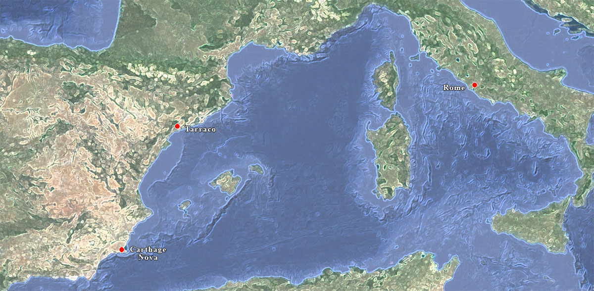
To get to know the origins of the port of Tarragona, we first have to look at the geographic situation and especially analyse the geomorphology of this part of the coast of Tarragona. Only then we can try to determine the exact characteristics in ancient times. When we do, we see that there were no significant circumstances or natural elements that could attract the attention of the old seafarers to anchor there, or to create a place to moor. No natural bay with deep waters, protected from the prevailing wind through the adjacent hills, as found, for example, by the Carthaginian general Hasdrubal in the mid-third century BC on the coast of the current province of Murcia, next to the mining mountains from Portman. The nautical importance of a route between the southeast of the peninsula and the African coast in order to benefit from the exploitation of the neighbouring silver mines justified between 230 and 228 BC. the creation of a new Punic colony. This city was given the proud name of Quart Hadasch, called Carthage Nova by the Romans, and is now known as Cartagena.
But that the circumstances of the bay of Tarragona were not great for a port does not mean that there was no port. A hill on the coast with the mouth of a river at its foot provided at least partial protection, and this already was quite something for a coastal area.
The Greek author Eratosthenes of Cyrene1 wrote in his big opus "Geographica" 2 about Catalonia, where on the coast a naustrasmos (anchorage) was, named Tarrákon. The question is how someone from Alexandria who had never been to the west of the Mediterranean was aware of this? Probably because the Greek skippers from the sixth century BC. sailed the Mediterranean Sea and passed on the various locations (including improvements) to each other again and again.
In the first century BC. the Greek geographer, diplomat and traveler Artemidorus of Ephesius3 visited the Iberian-Roman city of Tarraco and claimed that a port worthy of the name was missing.
Thanks to archaeological research we can explain these two statements and at the same time understand what the Second Punic War at the end of the third century BC. has meant for the historic port of Tarragona.
The second Punic war
Until the second Punic war there was only a small, probably Phoenician, mound village at this location. Archaeological research in the lower layers of Tarragona has mapped the stratigraphy and structure of this settlement from the 5th century BC.
Sailors from various parts of the Mediterranean brought their loads of wine, oil, salted fish, ceramics, textiles and jewelry to the Iberians in exchange for grain, slaves and ... galleons.
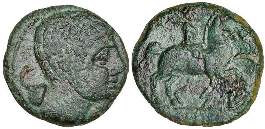
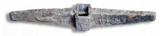
These sailors were perhaps the first to anchor here and they gave the settlement the Greek name Tarrákon. Later on the Romans turned it into Tarraco. The original population called the place Kese, a name that can still be found in the earliest minted coins from Tarraco (see Figure 5).
Tarragona may not have had a safe bay, but it was favorable to both the sea routes with Italy and, via the Ligurian coast, with the islands. That is why the Romans chose, in 218 BC, Tarraco as their main port of departure on the east coast of Iberia to resist the great Carthage Nova ruled by the Barkas family (Bárquidas). When Hannibal Barkas crossed the Alps during the Second Punic War and Rome had to incur defeat after defeat, the Roman commander Gnaius Cornelius Scipio Calvus moved to the Iberian Peninsula to fight against the Carthaginian army units still there in order to separate Hannibal from the supplies from its home port. Finally the Romans won the war at the battle of Cissa (Kese) and settled permanently in Tarraco.
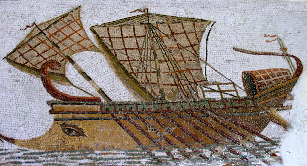
In the following years, large fleets of cargo ships accompanied by quadriremen and quinqueremen4 came from across the sea, and proved that the route to Tarraco was now popular and Tarraco itself offered an anchorage that was considered safe. Livius explicitly states that the great consular army of Publius Scipio in 217 BC. arrived at Portus Tarraconis (the port of Tarraco) where his brother Gnaius Cornelius Scipio Calvus had won the battle of Cissa the year before. The same Livius says that in the winter of 209, after the conquest of Carthage Nova, the Roman fleet overwintered in Tarraco, because the ships were no longer needed for the battle. According to the Latin nautical terminology, "Portus" means the place where ships spend the winter "(see the chapter ‘What is actually a port’ ). Therefore we may speak here of an authentic port.
Polybios5 wrote: “.... the Romans assembled their ships in Tarraco and the owners of the harbour, their allies, built docks, warehouses, streets, houses and public buildings to protect them.” In a warlike context such as then in Tarraco, the wintering center has clearly been transformed into a port headquarters. Portus Tarraconis was born.
Also with the advent of peace and the new Roman Province in 197 BC. Tarraco would retain the character of a naval port, in particular for the gradual occupation of the Ebro and Duero valleys. The city flourished and grew under these circumstances and had its own currency.
Also during the great civil war in the 1st century BC. the city would play a major role. After the battle of Ilerda6 and the pacification of Baética (southern part of Spain), Julius Caesar organized a large provincial meeting in Tarraco in 49 BC.
In 27 BC Augustus had to return to Tarraco when he got seriously ill during his campaign against the Astures7. He then lived in the city for two years, making Tarraco a second Rome with official embassies, political meetings etc. This was all possible because the port of Tarraco was the end of the main Mediterranean route between Rome and the Northern half of the Iberian Peninsula. Unfortunately there are no written sources that tell us anything more about the port. Archaeological research can maybe clarify the facilities of the port of Tarraco.
Research after the harbor
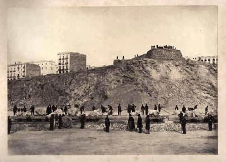
Despite the salinization of the port over the years, the archaeologist Hernandez Sanahuja (1810-1891), born in Tarragona, was still able to see the remains of some of the large pillars in opus caementicium 8 that were part of the Roman pier in the mid-19th century. These remnants were blown up a few years later because they should be a danger to ships that wanted to moor there. No piers anymore. Now we must deal with the geophysical research of the past 30 years and data from the scarce literary sources that we have.
As for Tarraco, there are few sources that refer to the routes to and from the city. The oldest source we have comes from Pliny, which states the travel time from Rome: et citeriorem hispaniam quarto (dies) 9 (... and four days to Hispania Citerior10).
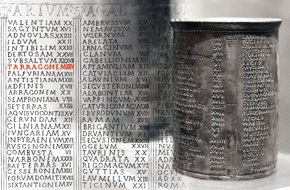
From the edictum de pretiis rerum venalium (edict on the prices of merchandise) by the emperor Diocletian from 301 AD. we know that the journey from the Orient to Hispania Tarraconensis costed 20 denarii, from Africa 8 denarii and from Rome (Ostia) 10 denarii. We can no longer consult the Peuteringer map11 for the country routes, because the part with Hispania has unfortunately been lost. However we do have another source, the so-called Vicarello cups. These silver drinking cups from the 1st century AD, found in a Roman bathhouse in Vicarello near Lake Bracciano (see our article "WATER"), represent the land route from Gades to Rome with all places, villas and distances.
A port did not always stand on its own. Often there were separate anchorages, small berths and mooring places around the harbour where ships could divert depending on the circumstances (see also Narbon). Tarraco, as the provincial capital, would have been the center of the first Iberian port system that stretched along the east coast of Spain from Roses in the north to Cartagena in the south, also including the Balearic Islands. One of those places would have been, for example, the Carbunclos, an anchor area just a few meters from the harbour bay. This is said to have been used in the late Republican and Imperial times and is rich in archaeological finds uncovered by underwater archaeology. Today, unfortunately, the place is hidden from view by the marina. The location would have served as a waiting place for ships before entering the port.
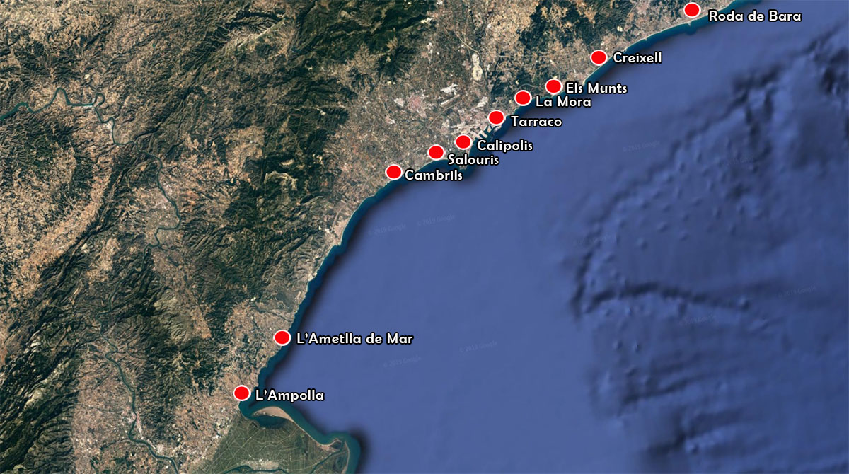
In addition, the large coastal towns in the Tarraco area also played an important role, such as Calipolis or Els Munts, places that, like Salouris, had a good harbour basin that offered sufficient protection to the ships.
It was also possible to anchor in Creixell, a place that was used together with Tarraco for the distribution of wine. Underwater archeology has provided much evidence for this, including recently (2017) a mortar.
Remarkable is also the existence of piers in southern Catalonia at L ’Amettla de Mar and L’ Ampolla.
The history of the port.
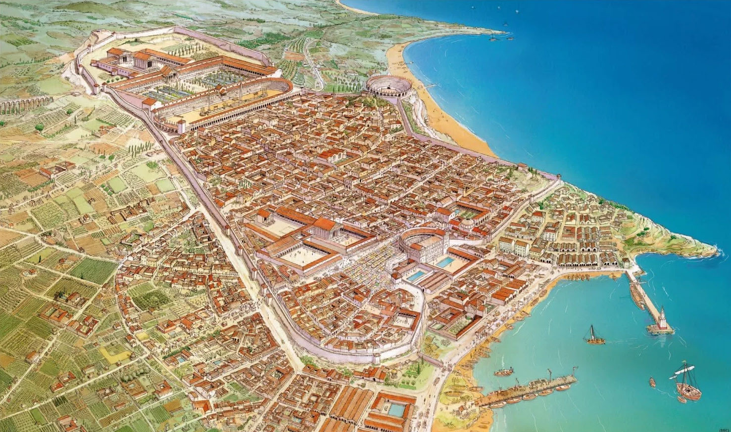
The history of the actual port of Tarraco is unruly due to the constant changes due to wars and conflicts, to urban development and renovation and to geological changes. Reconstructing the harbour as it looked in Roman times is difficult because we have no direct references to the coastline, harbour structures or descriptions of the location.
The Tarraco enclave was located about 70 km north of the Ebro river and 200 km south of Emporiae (Ampurias)12. Tarraco was also connected to the Lleida plain (west of Emporiae) so that the city took-in a strategic place for the Romans to consolidate their power in Spain and to establish a trade network.
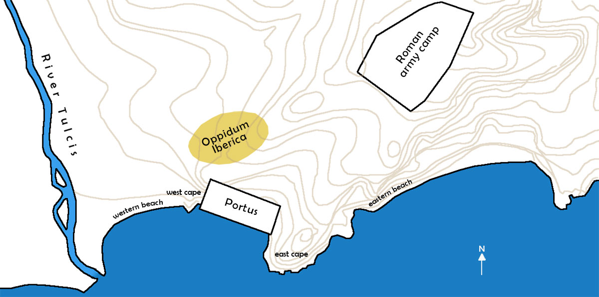
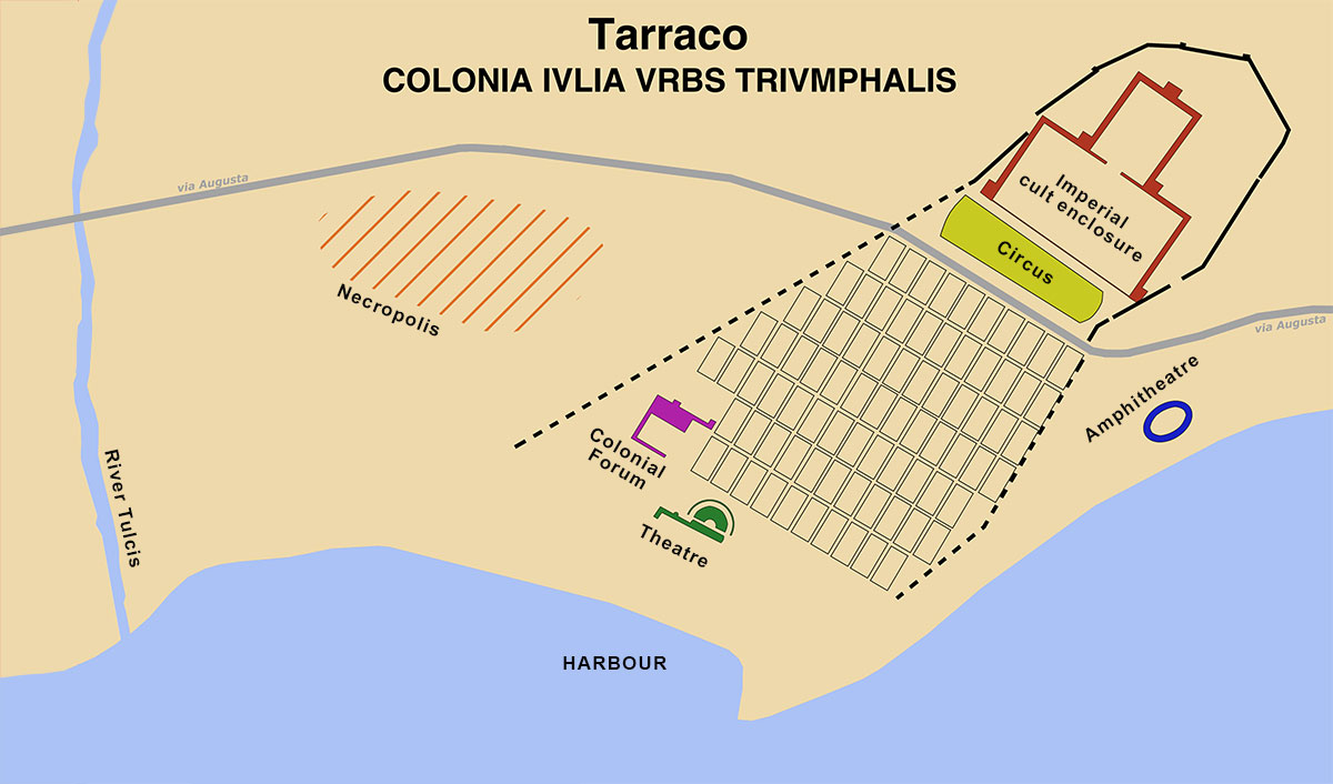
Tarraco lay on a hill, about 80 meters above sea level, from which one descended slowly towards the harbour area via a system of terraces. This hill stretched out to the sea and formed two coves. The first, the eastern one (now the Playa del Miracle) was closed off from the second bay by a promontory (east cape) that descended to the current Plaza dels Caros (this promontory had to disappear with the renovation of the modern harbour).
The western cove was closed by a natural interruption, the mouth of the Francolí (or Tulcis) river. This last cove was chosen in 218 BC. by the Romans as a landing-place. After the disembarkation, a military headquarters was established on the hill next to the old settlement.
The orientation of the Roman camp was NE - SW and covered an area of approximately 1,750 m by 550 m13. According to the latest data, the port of Tarraco itself would have had an area of between 15 and 17 hectares and the dock would have a depth of between 9 and 11 meters14. These properties made the port suitable for large ships to unload their goods at the docks, although most small and large ships would use the port for transit.
The wind was also an important element for the ships. By northern wind, the harbor was well protected by the cape. Only the east wind, which could be strong in the summer, could become a problem.
Another advantage of this location was the presence of fresh water from the Tulcis river, although the fast-flowing water from the river also contributed to the silting up of the port.
Due to the changed coastline and the silting up of the country, as happened at Ostia and Portus for example, the old Roman port lies currently on the mainland.
The city on the old oppidium was probably founded between the sixth and fifth centuries BC. Earthenware finds at the foot of the hill show that the indigenous population traded very early with Greek and Phoenician skippers.
After the Roman occupation in the third century BC. the settlement lived for a few years next to the Roman army camp, until the Romans built a new city and the settlement disappeared completely. Already within the 2nd century BC. the area became a residential area with a completely different structure and many new buildings. The presence of a pre-Roman population continued to exist in Tarraco, but just as before the Roman invasion, the increasingly important port is controlled from high-altitude Tarraco.
What is a port?
An important source for studying ports are the testimonies of geographers and historians about seas, ports and islands. With the help of, for example, the writings of Ptolemeus16, Strabo17 or Eratosthenes18, we know the characteristics of these ports, their location and even anecdotes linked to historical or mythological events.
Because many writers use the same word for different types of ports, the problem with the term "Portus" is still current. Although the Greek world was very rich in terms to define some kind of port, such as limén, ormós or ankyrobolion, the Roman world has only two: statio and portus. We owe this to Mauro Servius (fourth century AD) who gave a definition of each concept in his work Vergilii Aeneidem commemtarii:
Statio est ubi ad tempus stant naves, portus ubi hiemant 19. (A statio is where the ships are anchored for a while, a portus where they hibernate.)
In general, the various historical texts about Tarraco are quite contradictory. Rufo Festo Avieno20 wrote in the fourth century AD. about Tarraco:
inde Tarraco oppidum et Barcilonum amoena sedes ditium. nam pandit illic tuta portus brachia, uvetque semper dulcibus tellus aquis. (Then the Tarraco citadel and the beautiful location of the rich Barcilonas21, because a port unfolds there with safe arms and a land that is always irrigated by fresh water.)
Also from the hand of Pliny the Elder (23-79 AD) we know the Tarragona orography as described in his Naturalis Historia22:
[…] Cessetania region, Flumen Subi, Colonia Tarracon, Scipionum opus sicut Carthago Phoenorum. (The Cessetania region, the Subi river (= Tulcis), the Tarracon colony, founded by Scipio like Carthage by the Puniciers.)
Strabo23 (63 BC -19 AD) had never been to Hispania, but described in the first century BC in his work Geography perfect the coasts of Iberia, thanks to the information he borrowed from other authors such as Pytheas24, Homer, Asklepiades de Myrlea25 and many others. Strabo writes: “The first city is Tarracon, which does not have a port but is located in a bay and is sufficiently equipped with other benefits” 26.
The writer Eratosthenes wrote earlier, as we saw, that a city called Tarrakon was also a statio navum (the Latin equivalent of the Greek naustathmos, an anchorage) while Artemidoro said the place was not even suitable for anchoring.
Polybius wrote: “The Romans pulled their ships onto the land, and after gathering in Tarrákon those who had survived the defeats, they created a naval base with a view to protect their allies who had taken positions before the Romans' crossing”. This would indicate that there was indeed talk of a Portus.
Finally, we find testimony from the Roman historian Titus Livius (59 BC - 17 AD) who says the following in his work Ab urbe condita 27:
Ea classis ingens agmine onerariarum procul visa cum magna Laetitia civium sociorumque portum Tarraconis ex alto tenuit 28. (To see this fleet, with its huge column of transports, arriving at a distance and the arrival itself in Tarraco brought great joy to the city dwellers and their allies.) This text must be seen in the context of the arrival of the Roman armies led by Scipio during the course of the Second Punic War (218 -201 BC).
We are talking about 30 warships and 8000 soldiers coming from Massalia (Marseille) and reaching Tarraco in the year 210 BC.
The big question is what kind of port it is Livius describes? The actually military and later commercial port with its infrastructures are probably built a few years later, together with the Roman city. Upon arrival of the fleet, the "port" must have been a small open river port with limited draft where hardly was accommodation for 30 ships. It was perhaps possible to have the ships anchored in the eastern bay.
According to various texts, the port of Tarraco is described as Portus, therefore capable of accommodating ships during the 'mare clausum' (closed sea - see article: wintershipping) and should therefore be equipped with structures for the wintering of ships, a built-up area as opposed to a statio navium, an anchorage place where ships anchored only temporarily.
Other sources mentioning the port come from authors who speak about the characteristics of the city of Tarraco itself, such as Silius Italicus29:
[…] tunc hospita Tarraco Baccho, considunt portu. Secu-rae gurgite clauso stant puppes, positusque labor terrorque profundi. (... and Tarraco, so hospitable in Bacchus (where good wine was served) with its good harbour. The ships are tied to a safe shelter from the currents and where they could forget the fatigue and shock of the great sea). The text gurgite glauso is also translated as "Breakwater". The reference that the ships are bound by the shelter of the current is a fairly clear sign of the existence of a dyke, a dock or other harbour structure.
In conclusion, we can assume that the sources mention the existence of a port since the arrival of the Romans to the Iberian Peninsula. The location of Tarraco was the deciding factor in choosing the city as the capital and therefore an adjacent port had to be build. It is not possible to deduce from the available source material exactly when that port was built and what kind of port it was, given the abundance of conflicting sources.
The city is mentioned as a protective place with sufficient space, protected against storms, with fresh water to supply the boats, with space for a market linked to maritime activities. According to the sources, this location is logical because of the excellent circumstances.
Historiography and historical cartography
These sources are a valuable witness to the Roman port of Tarraco, because remains that have now disappeared are still wholly or partially shown on the city maps from the various periods.
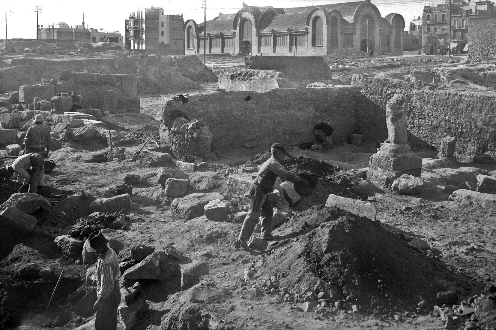
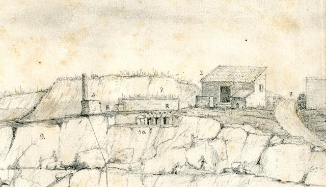
A large part of the area where the Roman port was located, in particular the Eastern Cape, was used as a construction quarry for the construction of the modern port, which led to the destruction of valuable historical material. For example, the Spanish writer Luis del Arco wrote in the early twentieth century in his art and monument guide of Tarragona: “Already in the mid-nineteenth century, Tarragona experienced a long commercial and industrial boom, making it necessary to expand and renew the harbour. For this they had to break down part of the hill, from the Rambla de San Carlos to the sea, and then from the ground rose, like a new Pompeii, the old and lush Tarraco. The centuries had buried all Roman remains. And when removing the ground to make way for the foundations of modern buildings, many statues, reliefs, friezes, tombstones, mosaics, amphoras, thousands of coins and objects of all kinds appeared and this entire world of archaeological material was thrown into the sea to fill the port “ 30.
We know little about the state of the Roman port during the Middle Ages. There is no indication whatsoever that supports the existence of a port. Today it is believed that the medieval harbour was an anchor area to the south of La calle Sant Miquel.
From the twelfth century the Roman harbour basin was used as an orchard and gardens because the bay was largely silted up.
From the thirteenth century there are various documented proofs of the use of the port of Tarragona: entrances and exits for ships, goods lists etc. Facts showing that the port was still in use, although we do not know in what circumstances, but it would certainly not have been very good.31
The first maps were made in the sixteenth century. The oldest testimony of the port, apart from classical sources, is that of a lawyer from Tarragona, Lluis Pons d’Icart (1518/1520 - 1587). For the first time we hear something about the presence of remains of a Roman pier in the city. Together with the engraving by Anton van der Wyngaerde (see Figure 1), this is the most important source of research into what was left of the Roman port in the sixteenth century and, in particular, about the location of the harbour. He speaks of a portu fabricato (an artificial harbour). Lluis then says that the harbour can be easily recognized by the remains, including those of a temple of Neptune32 laying in an orchard that was initially filled with sea water.
There is also a reference to the "port columns". These columns probably formed part of a large building, perhaps of the Roman theater. Pons d'Icart: "Many claim to have seen the columns in the orchard or vineyard. The sea was deep and the walls of the city were lower than the columns that were Corinthian and very well carved. It was not fifty years ago, as I learned from my father, my father-in-law and other old people who showed me the place where they saw ruins of large buildings. Where is unknown, but they said the land took up space." 33
Here we must again look at the engraving of Anton van Wyngaerde.
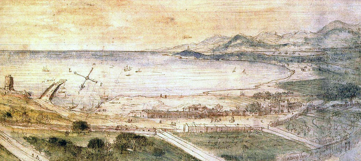
On the left we see the Roman pier (molo) that had to be replaced at the end of the 15th century. According to Pons d'Icart, the breakwater was said to be built of stone and mortar and the cement for the foundation was in the sea water with a certain type of stones on top. The pier would start on the rocks at the foot of the hill and end with a light beacon (lighthouse or lantern) called ‘Farellón. The stones on the pier were probably meant to be thrown into the water in order to break the waves.
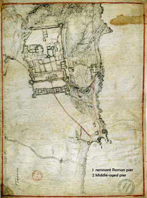
These boulders could also be interpreted as a structure of arches of masonry connected by pillars, through which water could flow into the harbour, which in turn corresponds to the remains of the pier that we see on the maps. Pons d'Icart also claims that the pier has often been restored because he himself has found various medals from various emperors who mention this34. On a map from 1642 (now in the General Archive of Simancas) we see the Roman pier in the middle of the sea and close to the coast drawn as a barrier, dominant above the level of the water. Probably not showing the physical dimensions but as a symbol that the pier is still there. As for the harbour itself, there is a big difference between the Wyngaerde map and this map. The engraving of Wijngaerde shows the Roman pier next to an extension of land that has taken over part of the former harbour dock.
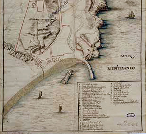
An anonymous document from around 160035 shows the main points of the site as well as the profile of the coastline. The lower part of the city, with isolated structures and orchards, is not filled-in here. Only the road that connected the upper part of the city with the harbour. We still see the Roman harbour with a remnant of the Roman pier.
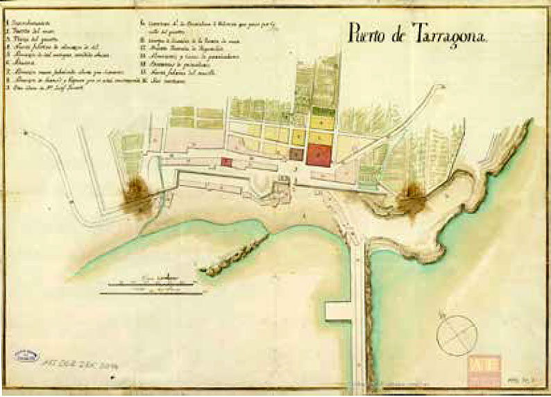
Also in the eighteenth century we still see the remains of the Roman pier on various maps, which is partly used as a quarry for new harbour extensions. On a map from 179736 we see one of the most beautiful views of the harbour area. What is particularly striking is that the Roman pier seems perfectly drawn and corresponds to the descriptions of various engineers as they lay in the sea like large concrete blocks.
According to the historian Morera, who, among other things, wrote a book in 1894 about the monuments of Tarraco which also describes where the Roman port should have been, these remains of the pier were removed from the water in 1834 because they would hinder the fishermen37. Morera writes about the pier: "The Romans needed protection in the western creek to protect themselves from the southern storms, which led them to build a concrete hard dike. The dike was not entirely solid, but the base on the rock was equipped with small drainage arches, so that the water could circulate freely and the waves were still broken.”
Archaeological data
The pier
As we said at the start of the article, we do not know exactly what kind of port we are dealing in Tarraco. That is why the terminology for the pier is interchangeable: promenade, dike, breakwater or jetty pier.
In the 19th century the Spanish historian and archaeologist, Buenaventura Hernández Sanahuja describes the port in his work "History of the Port of Tarragona from its origins to the present day (1859)". He writes about the breakwater:
“… That the water hit the rock in the past is proven by the fact that during the construction of a house at the crossroads of the calles de S. Magin and Sta. Tecla, nº1 fragments of a breakwater with firm bronze eyes intended to capture ships were found. In addition, there were noticeable remnants of a constructed dyke with stairs leading to the bottom of the cellars or underground warehouses, one of which ran towards the sea with a sloping surface to facilitate launching of the built ships." 38
At number 10: Roman buildings and reservoir appear
The location he indicated is far from logical and it is therefore very doubtful whether the found remains were part of a breakwater.39
Sanahuja also gives details about another breakwater:
“The break-water looked far from our dams, that is: it was not a road but it consisted of a long series of aligned pillars made of hydraulic concrete in large aligned wooden boxes on top of each other at certain distances, until they appeared above the water. From one pillar to the other were arches of brickwork that together formed a bridge. With this work of art they have succeeded in keeping the port clean of washed-up sand. Each pillar had its own skeg on the outside to break the waves. On top of the buildings that stood as warehouses on the sea bridge were barriers up to the height of the masts of the ships so that they were protected from the furious storms and could lie safely and comfortably in the harbour.” 40
This description corresponds to the remains of the Roman pier that we saw on the various engravings. If the description is true, then we can compare the breakwater with, for example, the one in Lepcis Magna in Libya where there was also a dock with warehouses, a temple and a lighthouse on the breakwater, although there is no evidence of this in Tarraco.
in 1776.
The supposed building structure with pillars (opus pilarum) was used and described extensively in Roman times. We see it for example in Pozzuoli and on frescoes. The decaying pillars that, in the case of Tarragona, have been submerged for centuries, were thus, according to many traditions, a source of danger for incoming boats.
Another controversial construction that many historians regularly wrote about would have stood at the mouth of the Francoli River. There are no physical data or indications for this on any map, although they are common on artist impressions of the port (see figure 8). Sanahuja also had a hypothesis about this building. He wrote that until 1892 people believed that there was also a western Roman pier. It also ran from the bottom of the hill of Tarragona into the sea to separate the water of the river from the water of the other breakwater.41 Although no evidence was found, such a second pier would have been logical. Partly against the supply of sediment from the often turbulent river.
The lighthouse
We do not know if there was a lighthouse in Tarraco because archaeological evidence is also missing here. The historiography on the other hand fully refers to a place known as "el Farelló". According to some historians, this would have been a lighthouse about three meters high at the end of the Roman pier 42. It would also be quite possible that there was no lighthouse but only a warning light, for example an amphora with burning oil. Partly due to an incorrect translation of the Catalan word farelló, which means "rock". A farellón would be a rock that lies on the surface of the water and is therefore not immediately visible. In that case it would call more for a light beacon to warn ships than for a complete lighthouse.
Underwater archaeology
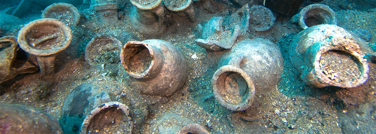
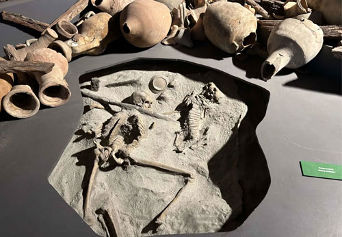
During the sixties, seventies and eighties of the last century much underwater research was done under the coast of Tarragona.
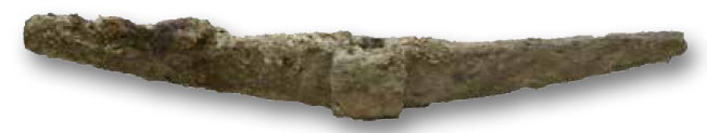
The artifacts found were cataloged in 2007 and contain many anchors, amphoras and pottery, parts of anchors, lead rods and even a sarcophagus.
However, complete wrecks from Roman times are missing at this location. Yet mapping the variety of anchors found, the different sizes, weights and decorative elements is an enrichment of knowledge of this area. They illustrate the anchorage areas near Tarraco and the routes of the merchant ships. They show, for example, how an important pier was used in the area during the Republican and Imperial times and that, before you entered the harbour, there was apparently an anchorage point.
Other areas with a lot of maritime activity are Creixell and L’Ampolla (see Figure 10). At the latter, large stocks of anchors with an inscription from the manufacturer were found. The locations mentioned do not necessarily have to be harbours. In many cases they were merely boat houses that would have served as a refuge before arrival at the port of destination.
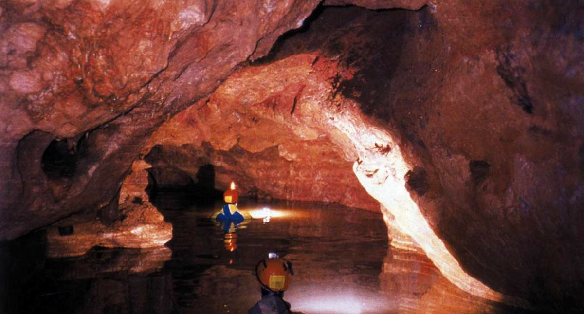
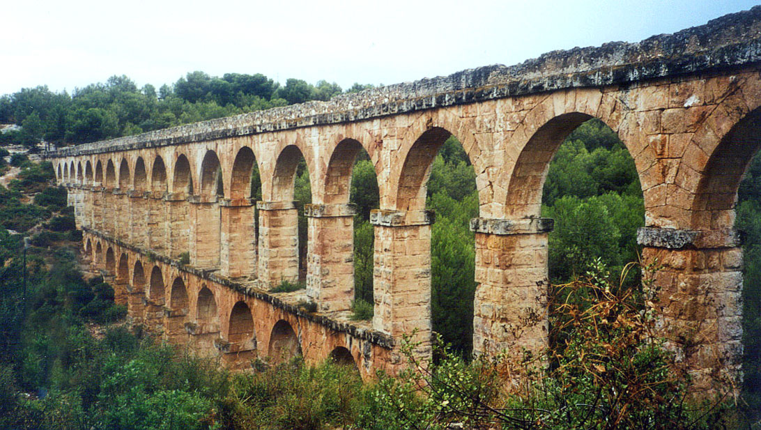
The old town of Tarragona was equipped with a "cova urbana", a 3 km underground system of galleries, caves and springs and an underground lake of 5000 m2, suitable for drinking water. These were already known in the 19th century but rediscovered in 1996. There was also a "cuniculus" (underground aqueduct) from Roman times, 13 meters below the Roman city and also two aboveground aqueducts with water from the Francoli and Gaià rivers.
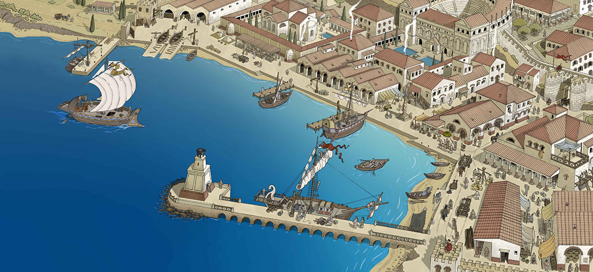
Warehouses and harbour routes
The first horrea (218 BC-30 BC) were mainly for the storage of Iberian grain for Rome and consisted of around 20 wooden structures in the middle part of the city. The majority of the preserved horrea from the heyday of the empire are located in the suburb of the western harbour. These were large rectangular structures with trade offices along wide harbour roads.
The horreum on the plot known as 22a consists of three parts of 18.40 x 6 meters and an estimated total area of 110 m2, built along the waterfront. The basement of the warehouse was made in opus caementicium. The adobe44 walls were reinforced with ashlar45 and had large doors. There was a pebble floor in the three rooms prepared for a paved surface that has not been preserved. It is also claimed that this was an insulating floor against groundwater with a tabulatum (wooden plank floor) placed on it to allow ventilation so that products such as grain had a longer lifespan.
Later, the warehouses were probably given a monumental entrance with a colonnade. The Tarraco horrea from the heyday of the empire can be compared to the horrea in Lepcis Magna, the porticus Aemilia in Rome or the warehouse of Hortensisus and Galba in Ostia.
At the beginning of the second century we see that in the described warehouse the western compartment is provided with a white pavement, while the eastern section receives walls at different levels. Many parts of warehouses are then converted into residential houses. In the third century whole parts are no longer used and from the end of the 3rd and 4th centuries only a few tombs can be found.
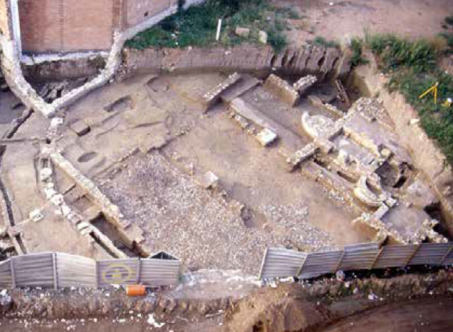
The theatre
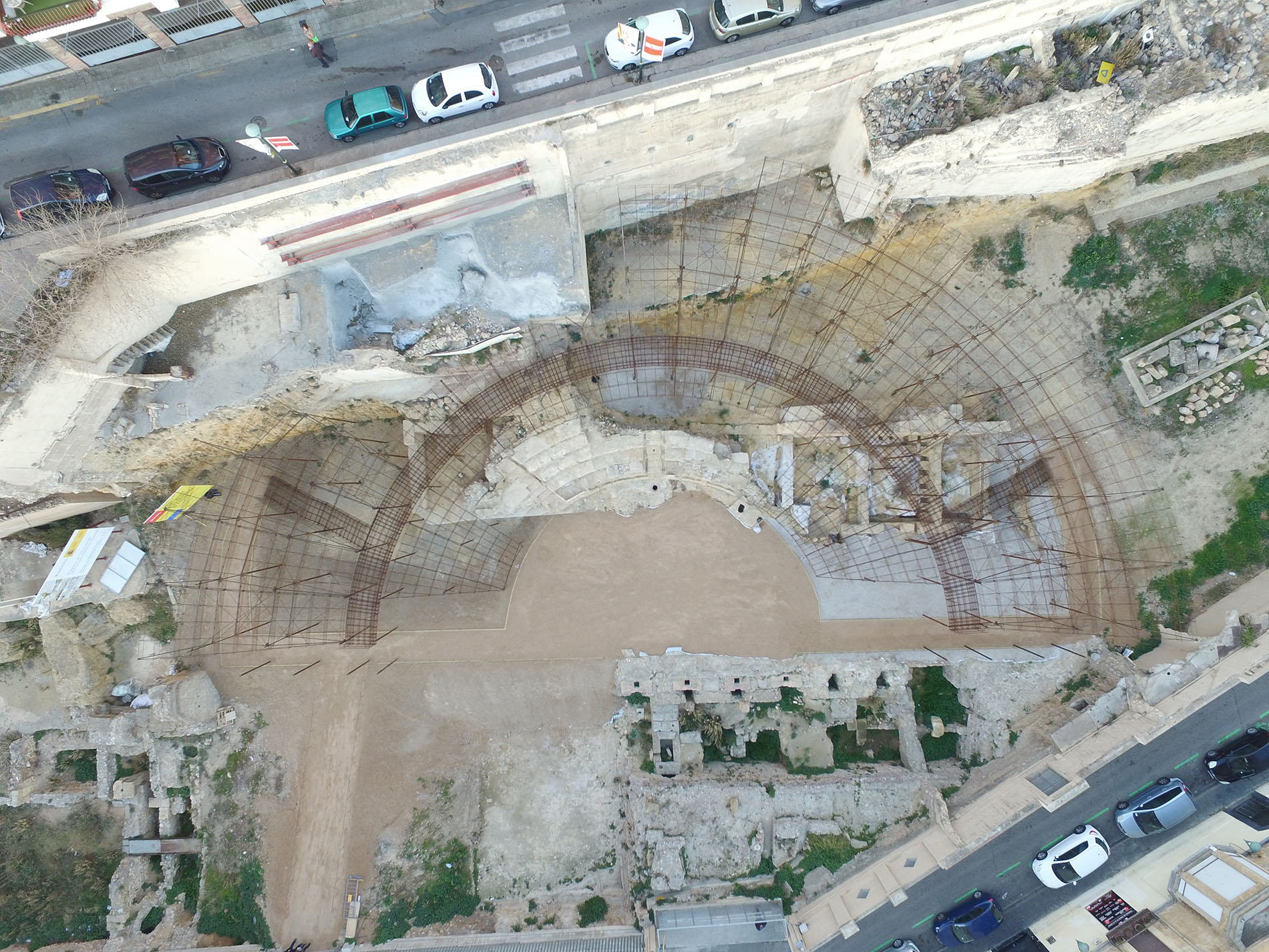
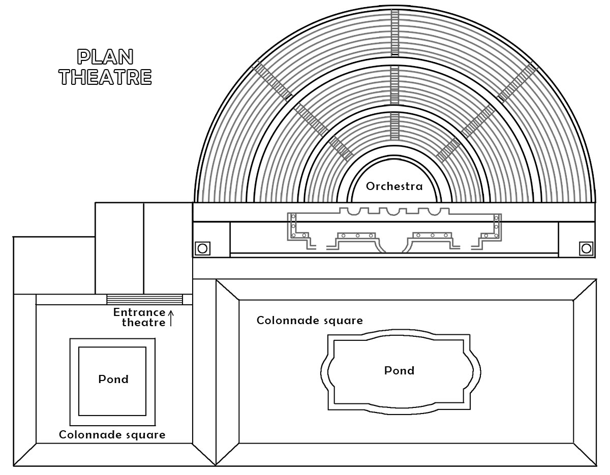
Recent excavations in the Roman theatre have revealed a number of spaces prior to the construction of the theatre that were probably used as storage spaces or taverns and were part of the harbour structures from the 2nd - 1st century BC.
The theatre itself was built in the first half of the first century AD. in the area that used to be the trade zone connected to the port. Only a few parts have been preserved, partly due to the many adjustments and changes over the years. There are still remnants of the eastern part of the foundation of the stage, the first steps of the spectator stand, the foundation of the front stage made of concrete as well as a number of rectangular and semicircular exedrae (semicircular spaces). In the back was a double row of openings where the curtain hung.
During the construction of a porticus postscaenam (space behind the stage with a colonnade) a large water feature was placed on the left with a space used as a nympheum consisting of a wall with columns around a large pond with fountains on the outside. There were marble craters on pedestals on either side of the nympheum from which water flowed down towards the nympheum and collapsed three meters below into a pool of water.
For the construction of the theatre a piece of the citywall and the harbour construction probably had to be demolished, creating a perfect view of the sea.
The Roman bathhouse
The public thermal baths were built at the end of the second century or the beginning of the third century AD. on the foundations of old warehouses. According to an inscription, this would have been the Thermae Montanae 46.
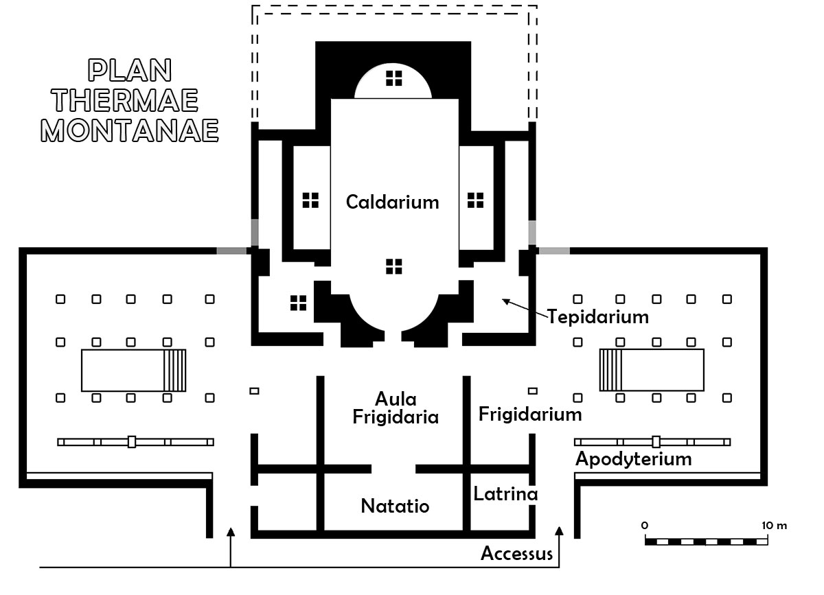
The public building was built according to the then prevailing standards of Roman society and became, as it were, the new epicenter of the port area. The building was rich in painting and sculpture. The latrines made use of the old horrea from the century before.
The building was cruciform. On the long axis were successively a natatio (swimming pool), a frigidarium (cold water bath), possibly a tepidarium (lukewarm intermediate bath) and a caldarium (hot water bath). There were other spaces on the west and east sides, of which only those on the west side have been preserved. The complex was accessible from the north and possibly from one of the sides. Just like the theatre and the amphitheatre, the baths remained in function until the 5th century AD.
The sales areas. Markets and the Forum
The lower part of the city developed from a sandy water area into a harbour neighbourhood with all the necessary facilities. The forum of the city also played a central role in this.
The forum of Tarraco was dug up between 1926 and 1929 and later, in 2002/3, a new investigation followed.
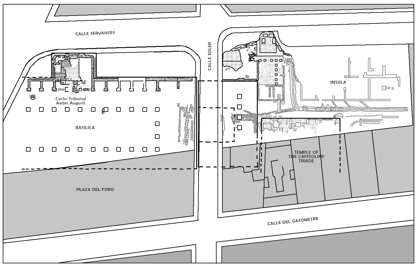
The construction began in the late Republican era with a square and a temple dedicated to the Trias- Capitolinus (Jupiter, Juno and Minerva). The stage of this Capitol temple was later raised to a temenos (sacred space) with columns. The orientation was in a way that from the temple you could see the ships coming from the sea.
At the time of August the Basilica Iuridicalis (court of justice) was built including a floor with a colonnade. Under Tiberius a central colonnade of two floors high was added and the forum was expanded with a forum adiectum (added forum) prior to the basilica with its open square with a colonnade built above a cryptoporticus.
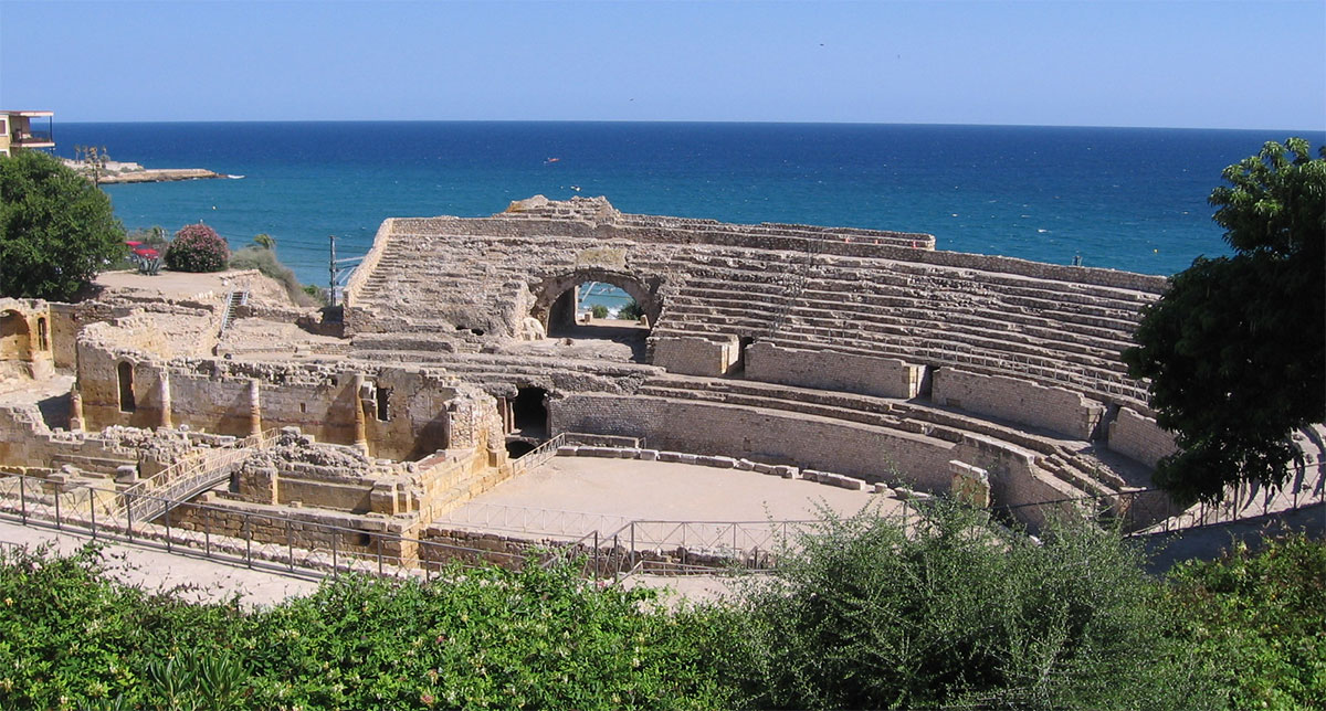
The Amphitheatre
Near the forum, an amphitheatre was built at the end of the1st century / beginning of the 2nd century AD. The amphitheatre was mainly used for gladiator and animal games. It had a capacity of 15,000 spectators and an area of 130 x 102 meters47. Apparently Panem et circensis (bread and games) played also an important role in Roman Tarragona of that time.
Conclusion
A city like Tarraco, which, according to the sources, played such an important role, especially during the second Punic War and the Roman conquest of Spain as a naval port, where a Roman fortress was converted into a thriving city, where, in addition to the locals, many Roman families settled there must have been almost certainly a thriving commercial harbour, although there are no signs of the actual harbour. Also epigraphic references from skippers, ships or wrecks are missing. However, many archaeological finds have been made under water pointing to a large maritime trade. If we take the many notes and engravings from the past 400 years seriously, there must also have been a pier/ breakwater as we know from Pozzuoli. Also the remains of the many horrea indicate a port with facilities as you might expect in a harbour that, after my believe, may carry the name Portus. A port that, according to the latest available data, occupied an area between 15 and 17 hectares with a harbour basin that had a depth of between 9 and 11 meters, allowing both large and small ships to dock here and to unload or take in their cargo.
Sources- - EL PUERTO DE TARRACO EN ÉPOCA ROMANA (siglos ii aC – iii dC).Fuentes, historiografía y arqueología by Patricia Terrado Ortuño
Notes- 1:Eratosthenes of Cyrene (ca 280-195 BC), geographer and astronomer and third director of the library of Alexandria
- 2: Geographica - three-part work about the then known world
- 3: Artemidorus Ephesius - Greek geographer wrote 11-part papyrus. Around 100 before Chr.
- 4: Quadrireem - galley ship with 4 rows of rowers above each other; Quinquereem - galley ship with 5 rows of rowers on top of each other
- 5: Polybius - Greek historian and friend of Publius Cornelius Scipio Aemilianus Africanus minor. Polybius reported, among otherthings, on the destruction of Carthage
- 6: The Battle of Ilerda was one of the confrontations between the followers of Julius Caesar (the populares) and Pompeius (the optimates) during the civil war between Pompeius and Caesar in 49 BC.
- 7: Astures - people in the northwest of Hsipania
- 8: Opus caementicium = Roman concrete (read "Pompeiopolis, Roman port in Turkey"
- 9: Pliny - Naturalis Historia 19.1
- 10: Citeriorem hispaniam was the original name of the province of Hispania Tarraconensis
- 11: The Tabula Peutingeriana or Peutingerkaart is a copy of a Roman travel card from the 3rd or 4th century. It covers an area of Great Britain, Spain and North Africa in the West to the Ganges River in the east
- 12: Emporiae - originally Phoenician / Greek city in the north - east of Hispania. They fought on the side of the Romans during the Punic War. The Romans landed there during the 2nd Punic war in 218 BC. and founded a Roman city alongside the Greek one.
- 13: Macias y Remolà, 2010, p. 131.
- 14: These preliminary data were discussed at a recent congress at the Institut Català d'Arqueologia Clàssica (Tarragona) on the latest data on the port of Tarraco: http://www.icac.cat/wp-content / uploads / 2016 / 12 / 43_sem_port.pdf
- 15: In 60 AD Galba (3 BC - 69 AD) was appointed by Nero as legatus Augustus pro praetore (governor) over Hispania Tarraconensis. He governed these provinces for eight years.
- 16: Ptolemy - (87 - 150 AD) Greek astrologer, astronomer, geographer, mathematician and music theorist who lived in Alexandria. Wrote, among other things, a handbook on geography that reflects the geographical knowledge of the Greco-Roman world at the time.
- 17: Strabo - Greek geographer and philosopher (64 BC - 25 AD) Geographika, a source of knowledge about many European, Asian and African peoples of his time, about which he mentions the most interesting stories
- 18: Eratosthenes - Greek geographer (276 BC and 273 BC)
- 19:Serv. A. 2. 23.
- 20: Postumius Rufius Festus (Avienius) was a Roman poet from Volsinii (near Bolsena-Italy). He wrote, among other things, Ora maritima, describing the coastline from Brittany to the Black Sea.
- 21: For an explanation of Barcilonas see EL PUERTO DE TARRACO AND ÉPOCA ROMANA - Patricia Terrado Ortuño page 72
- 22: Plin. Nay. III, IV, 21
- 23: Strabo, Greek geographer - Strab. 3.4.7
- 24: Pytheas of Massalia - Greek explorer from the 4th century BC.
- 25:Asklepiades de Myrlea - Greek philolog and geographer and historian (around 100 BC)
- 26: Strab. 3.4.7.
- 27: Ab urbe condita ("From the Foundation of the City"). Titus Livius described in 142 books the history of the Roman people until the death of Drusus in 9 BC
- 28: Liv. 22. 22. 1- 2.
- 29: Tiberius Catius Asconius Silius Italicus was a Roman politician, successful businessman and epic poet (25 - 101 AD)
- 30: del Arco, 1906, p. 28.
- 31: Bonet, 2009
- 32: For the Temple of Neptune, see Macias, 2004.
- 33: Pons d'Icart, 1572, Cap. 38
- 34: Pons d'Icart, 1572, Cap. 38
- 35: This map from 1600 is in the Collection D’Anville (National Library of France)
- 36: Simancas General Archive (1797)
- 37:Emili Morera i Llauradó (Tarragona, 1846 - Tarragona, 1918), Spanish historian and archaeologist: 1910, p. 9.
- 38: Hernández Sanahuja, 1867, p. 136.
- 39: At the place mentioned by Sanahuja the Roman theater used to be. A dyke beneath that theater is hard to imagine.
- 40: Hernández Sanahuja, 1867, p.136.
- 41: Sanahuja: Historia de Tarragona: des los más remotos tiempos hasta la época de la restaura-ción cristiana publicado and 1892,
- 42: Mar et al., 2012, p.185.
- 43: Photo: Tarragonaturism.cat
- 44: Adobe = a building material consisting of sand, water, clay and organic materials such as straw and manure.
- 45: Large natural stone carved on one side
- 46:CIL II² / 14, 1004 = RIT 155 (s. Ii-iii dC): M (arco) Aur (elio) Vincentio v (iro) (erfectissimo)] p(raesidi) [p (rovinciae) H (ispaniae)] / Tarraconensis ac su [per] / omnes reliqua [os] praesides ius / tissimo restitutori / thermarum Montanarum / Knife [s] ius Marianus / cur (ator) r (egg) p(ublicae) Tarraconensis.
- 47:Duncan Fishwick, The Imperial Cult in the Latin West, BRILL, 1990


 We are committed to providing versions of our articles and interviews in several languages, but our first language is English.