“You, O Roman, govern the nations with your power - remember this!
These will be your arts – to impose the ways of peace,
To show mercy to the conquered and to subdue the proud." 1
A report by Alexander Cattrysse, geophysical surveyor
In their hunger to bring the rest of the world also under their influence, for enjoying their "civilization, peace and prosperity" the Romans decided that now it was the turn of that big island in the Septentrionalis Oceanus 3, that should be called Britannia. Well, this was not just an altruistic idea, the island was rich in mineral resources such as lead, tin 4, gold and silver, and had large fertile fields where corn could be grown, a cereal that in ever larger quantities was necessary to feed the population of the Roman empire and its capital.
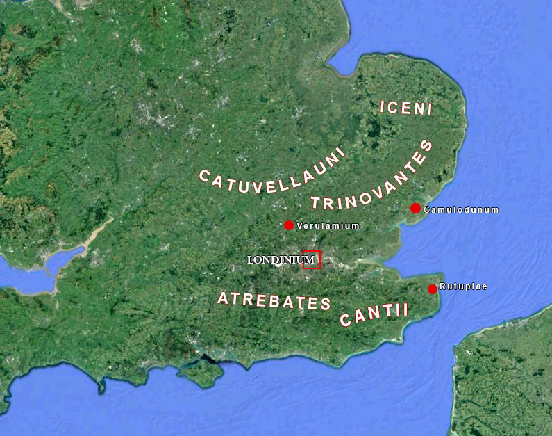
In the year 43 AD it happened. The emperor Claudius invaded Britannia and founded Londinium in the border area of various indigenous tribes: to the north of the city the Catuvellauni and the Trinovantes and in the south the Atrebates and the Cantii. These peoples were hostile to each other. It is only with the conquest of the region by the Emperor Claudius that stability was restored. Although traces of occupation dating from the late iron age have been found within the territory of the Roman Londinium, one cannot speak of an earlier city on that place. Londinium may therefore be regarded as an original Roman city.
Peace for only a short time
Claudius certainly brought tranquility in the region. He made peace with the tribes. Unfortunately a peace that lasted not very long. The various tribes were vassals of Rome and had their own local king, for example the Iceni, a tribe in present-day East Anglia. Their king Prasutagus, who was married with queen Boudica, ruled as a nominal independent ally of Rome, and left his kingdom jointly to his daughters and to the Roman emperor in his will. However, when he died, his will was ignored, the kingdom annexed and his property taken by the Romans. According to the Roman senator and historian Tacitus, Boudica was flogged and her daughters raped 5.
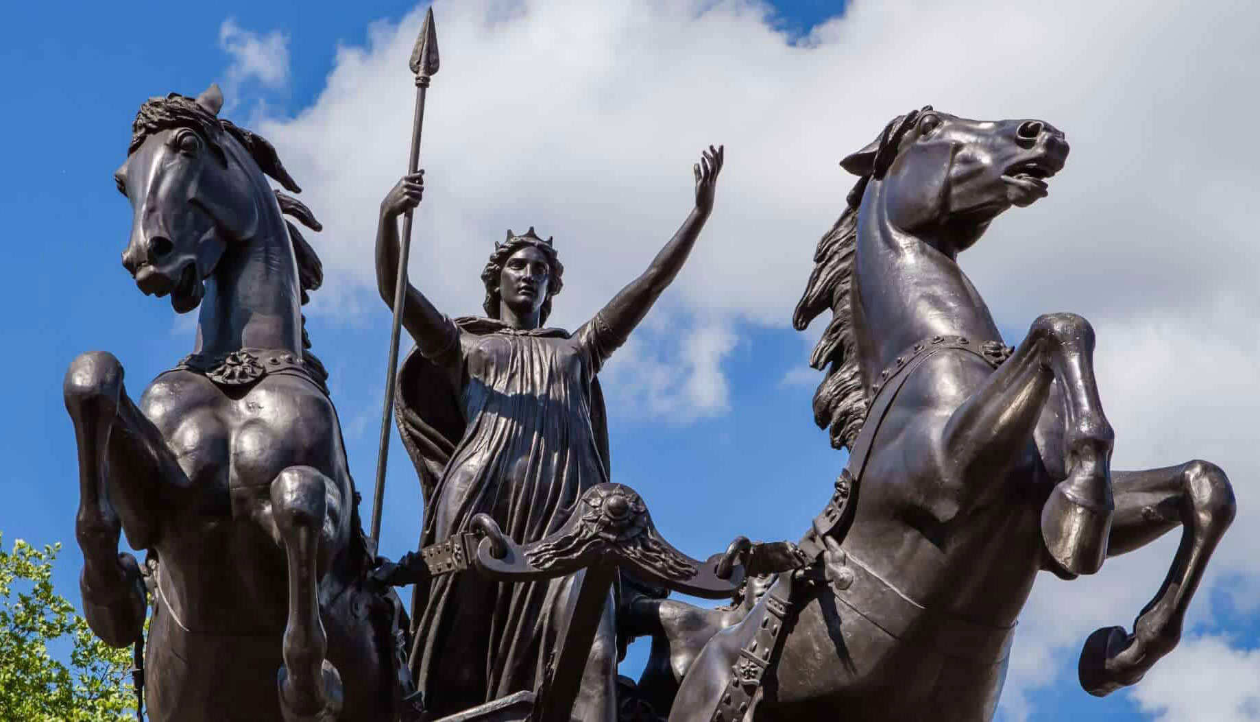
In AD 60 or 61, during the reign of Nero, when the Roman governor Gaius Suetonius Paulinus was campaigning in another part of Britannia, Boudica led the Iceni, the Trinovantes, and others in revolt. They destroyed Camulodunum (modern Colchester), the former capital of the Trinovantes, but at that time a colonia (a settlement for discharged Roman soldiers) and the site of a temple dedicated to the former Emperor Claudius. Upon hearing of the revolt, Suetonius hurried to Londinium, because the 20-year-old commercial settlement was the rebels' next target. Suetonius lacked sufficient troops to defend the settlement and evacuated and abandoned Londinium.
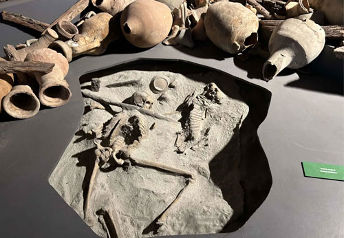
Boudica indeed led an army big enough to defeat the detachment of Legio IX Hispana, and burned and destroyed Londinium and Verulamium (modern St. Albans, north of Londinium) completely. An estimated 70,000 – 80,000 Romans and British citizens were killed in the three cities by the army of Boudica, many by torture 7. Suetonius, meanwhile, regrouped his forces, possibly in the West Midlands and, despite being heavily outnumbered, he decisively defeated the Britons. The crisis caused Nero to consider withdrawing all Roman forces from Britain, but Suetonius' victory over Boudica confirmed Roman control of the province. Boudica is today considered a British folk hero 8.
The resurrection of a city
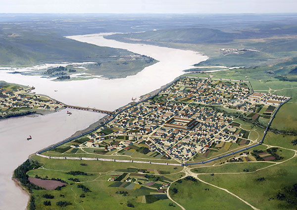
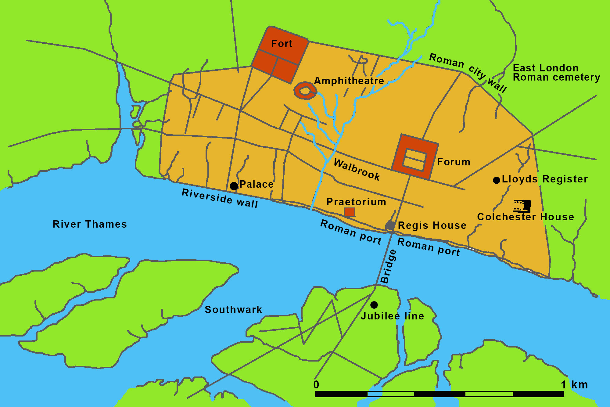
After their victory the Romans decided to rebuild Londinium. Within ten years the city was resurrected and grew steadily until it reached its peak in terms of population around 140 AD. With its 45,000 inhabitants Londinium was one of the largest cities outside Italy. During the 2nd and 3rd century the city evolved further and was an important residential and commercial centre. Many public buildings made of brick were erected, such as the largest forum north of the Alps, a praetorium (military headoffice), bathhouses, an amphitheatre and large horrea (warehouses). Londinium took over the function of capital of Brittania from Camulodunum and also the administration. Around 100 AD the Romans started with the enlargement of what was left of the first harbour, which had been destroyed by Boudica.
A Roman port on the North Sea
The port of Londinium has a long history. For the last 2000 years the port was almost continuously in use. Consequently the archaeological history of this place is represented by an almost continuous succession of archaeological layers that stretch over two kilometres, with a width of 125 meters and a depth of almost ten metres. However, in this article we will only look at the harbour during the Roman period, so from the foundation up to the year 500, when the city was given up by the Romans 9.
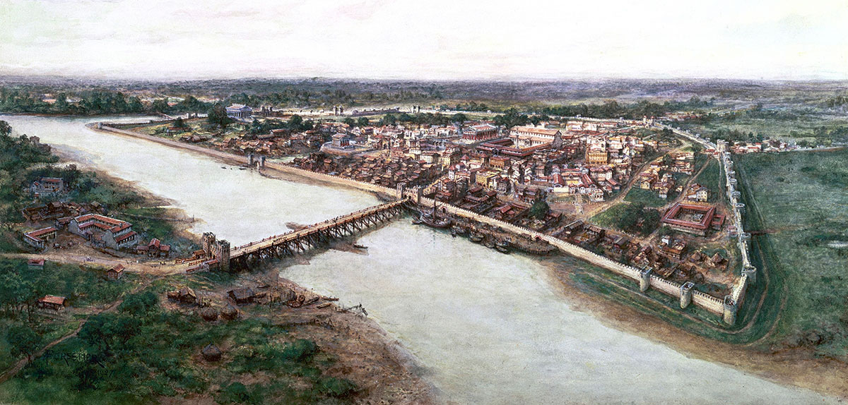
The site Londinium was chosen by the Romans for a good reason. The Thames was a tidal river. The water level in the river stood at low tide ca. 1 meter below the average sea level, and almost 1.5 metres above sea level at high tide. Consequently at high tide the river had a width of almost 1 km.
Near the modern district of Southwork were two islands in the river. Here, at low tide, the river width was only up to 300 meters. Consequently this location was considered to be the ideal location for bridging the mouth of the Thames. An extra advantage was the fact that this was also the place of an intersection of roads, to the west in the direction of Verulamium (modern St. Albans), to the east to Camulodunum (modern Colchester), and to the south towards Rutupiae (modern Richborough) (see figure 2).
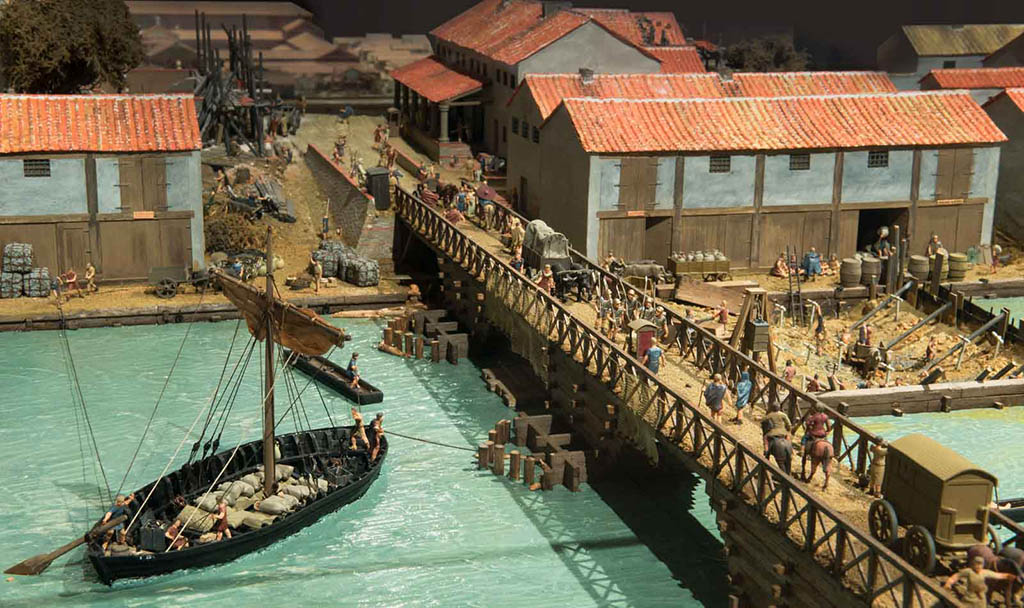
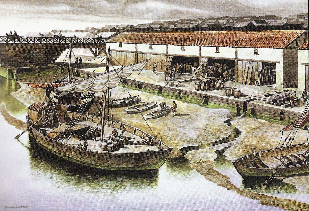
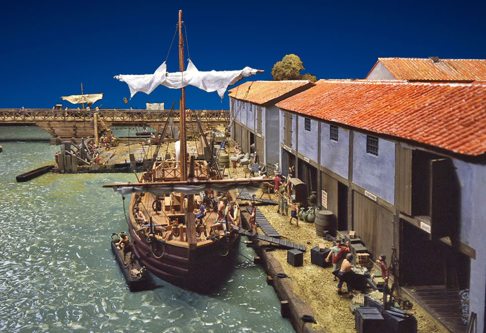
It is not a coincidence that in the vicinity of this narrowing also traces of a first 'port' have been found. Traces of a zone reinforced with flint and lime along the banks pointed to the landing area of a ferry around 50 AD. In the neighbourhood of Regis House traces have been found dating to the year 52. Here a bank reinforcement was found in conjunction with indications of a yard and various wooden buildings. This first settlement was destroyed during the rebellion of Boudica. The first real port development happened in the second half of the first century. Reinforcements and traces of wooden buildings belonging to this new port-bank, from the years 60-70 AD, have been found around Regis House. The buildings were identified as glassware workshops and as spaces for trans-shipping goods.
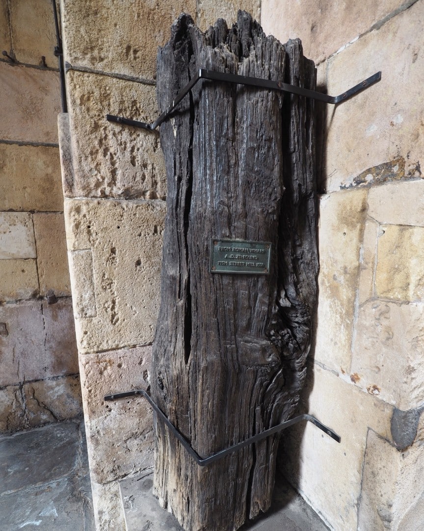
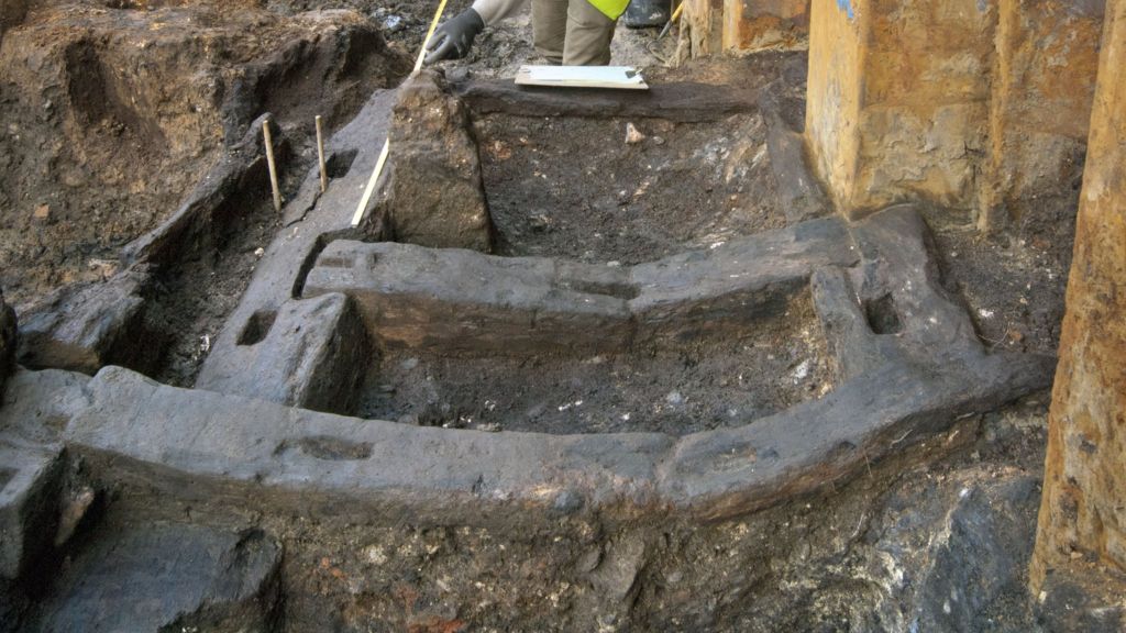
The harbour was extended with a quay. The construction consisted of a framework of heavy beams (see figure 6). A two-meter-high quay wall was further inland anchored to a pole that was struck into the ground. The resulting framework was filled with flint, limestone and broken tiles. In this way a paved surface was created. Some of the timbers from that quay had clearly been taken from military stock piles, since the end-grain has been branded with stamps, one of which may have read TRAECAVG, perhaps attesting to the presence of a Thracian unit. Thus it can be surmised that London’s first major harbour facility was built by the state, rather than by private merchants. In addition to the traces of wooden buildings traces of brick houses, dating from the first half of the first century, were found. From this period, however, any trace of a Roman bridge is missing. In all likelihood transport across the river happened via a ferry. Also traces of a 57-meter-long pier were found.
The bridge
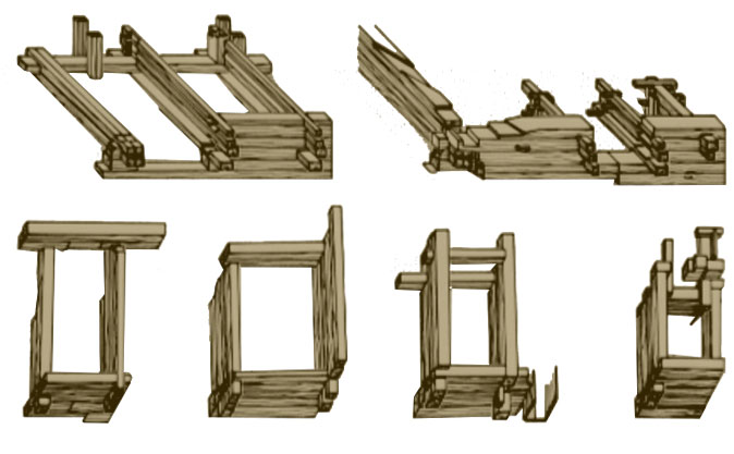
The first traces of the Roman bridge are dating from the end of the first century. The first wooden bridge was probably built somewhere between the years 80 and 100 AD. At the same time new buildings were erected along the entire quay. We are talking about warehouses and commercial offices with wooden floors, supported by foundations of wooden poles. On the portside they were open, but could probably (as we see in other Roman cities) be closed with wooden partitions. The roof construction too was supported by wooden pillars. Around the year 90 the first quay, described above, was replaced by a new one, this time with a walkway consisting of pebbles. How was this Roman bridge built? The entire bridge was made up of individual caissons. These were placed on the bottom during low tide. According to some, at the places where the water wasn’t drying up the caissons were submerged. According to others on those places poles were driven into the soil. Method 1 results in a firmer construction, but it is more difficult to immerse the caissons at the correct position. Method 2 would solve that problem.
Further developments
The port as described above had a further development at the beginning of the second century. A land elevation was made whereby a new bank was created, this time reinforced by a simple system of planks and poles. On this new quay brick and limestone buildings were erected. The old warehouses were converted into commercial offices. This expansion of the port, however, was short-lived. The Hadrianic fire 14, somewhere between 120 and 130 AD, destroyed a large amount of buildings around the Roman bridgehead. The remains of the buildings were removed and reused for a new reconstruction. The bank reinforcements found at Custom House, New Fresh Warf, Magnus House and Baynard's Castle date from the middle of the second century.
In the late second century we see an expansion of the harbour. Probably this extension was related to the construction of a defensive wall on the landward side of the city. One needed a larger dock for the import of construction materials. Along the waterfront fire resistant brick buildings were built. Starting from the second half of the third century we see that parts of the quay walls fell into disuse, partly because a regression of the sea took place, whereby parts of the quay were removed from the water. Only limited parts of the port remained in use till the fifth century, and by the year 500 the port was abandoned.
The economic peak of Londinium fell between 50 and 130 AD. From this period artefacts have been found from Italy, Greece, Palestine, Syria, Turkey, North Africa and southern Gaul. This trade from the areas around the Mediterranean is closely linked to the presence of Roman legions and officials in and around the city. These persons wished to preserve their lifestyle and thus the import of several Mediterranean goods. As the local population romanised more, the demand increased and consequently the import.
About 150 AD a decline in trade could be observed. The decline is probably connected with a drastic drop in population in the city. Although the Hadrianic fire was part of the cause, it is assumed that this relapse was due to the outbreak of an epidemic. Such an outbreak is not alien to an international port. The decline in trade is among others recognizable by the relapse of imported pottery, consistent with an increase in locally produced pottery.
The port of Londinium tells the story of the Roman Empire on an area of only 25 hectares. The port and consequently the city have been able to benefit from the growing prosperity of the Roman Empire and the Pax Romana during the first and second century. However, from the middle of the third century the port begins to suffer from the political malaise within the Roman Empire. The trade in the city reoriented itself away from the old central point, the Mediterranean Sea, to central and northern Europe. Eventually the economic activity shrinks continuously as the Roman Empire becomes further under pressure, until finally the port installations fall into disuse and the city was taken over by the Saxons.
- Notes
- 1:Virgil, Aeneid book VI: tu regere imperio populos, Romane, memento. Hae tibi erunt artes, pacique imponere morem, parcere subiectis et debellare superbos.
- 2:Photo: Rocio Espin Pinar.
- 3:Septentrionalis Oceanus: Roman name for the North Sea according to Pliny the Elder, Naturalis Historia.
- 4:Read also our article 'ICTIS'.
- 5:"Iam primum uxor eius Boudicca verberibus adfecta et filiae stupro violatae sunt", Tacitus, Annales 14.31.
- 6:Photo: historic.uk.com.
- 7:Tacitus, Annales 14.33.
- 8: S. Pruitt: "Who was Boudica?", www.history.com (retrieved 2018-01-31).
- 9: Due to several reasons the location of the river was about 150 m. to the north in Roman times.
- 10:Photo: Museum of London.
- 11:Gustav Milne, 1985 (Institute of Archaeology, University College London).
- 12:Photo: Timothy Finch.
- 13:Photo: Katie Wignall.
- 14:The Hadrianic Fire: within the ten years following the visit of Roman emperor Hadrian to Brittania in AD 122 a huge fire or possibly a series of fires destroyed a 100-acre (0.40 km2) area of the ancient city.
- 15:Photo: Museum of London Archaeology (MOLA).
- 16:Scale model in Museum of London.
- Sources
- -Bishop H. 1993. Regis House, 29, 40-46 King William Street; 4-12 Monument Street; 17-25 & 26-28 Fish Street Hill, London EC3: An archaeological assessment. London: Museum of London Archaeology Service.
- -Brigham T. 1990. The late Roman waterfront in London. Britannia volume XXI. London: Society for the Promotion of Roman Studies.
- -Brigham T. & Watson B. 1994. Regis House: the Romans erect their port. Current Archaeology 158: 44 – 47.
- -Brigham T. & Watson B. 1994. Regis House, King William Street / Fish Street Hill, EC4, City of London: An archaeological Evaluation and Research Design. London: Museum of London Archaeology Service.
- -Brigham T. 1998. 12 Arthur Street, London EC4, City of London: An Archaeological Assessment. London: Museum of London Archaeology Service.
- -Dyson T. (ed.). 1986. The Roman quay at St. Magnus House, London. Special paper No. 8 of the London and Middlesex Archaeological Society. London: The museum of London and the London & Middlesex Archaeological Society.
- -Hobley B. 1981. The London waterfront: the exception or rule? in Milne G. & Hobley B. (eds.). 1981. Waterfront archaeology in Britain and northern Europe. The council for British archaeology: research report No 41. London: The council for British archaeology, 1- 9.
- -Marsden P. 1981. Early shipping and the waterfront of London. in Milne G. & Hobley B. (eds.). 1981. Waterfront archaeology in Britain and northern Europe. The council for British archaeology: research report No 41. London: The council for British archaeology, 10-16.
- -Marsden P. 1985. London in the 3rd and 4th centuries. in Grew F. & Hobley B. (eds.). 1985. Roman urban Topography in Britain and the western Empire. The Council for British archaeology: research report 59. London: The Council for British archaeology, 99-108.
- -Millet M. 1995. Book of Roman Britain. English Heritage. London: B.T. Batsford.
- -Milne G. 1985. The port of Roman London. London: B.T. Batsford Ltd.
- -Milne G. 1995. Book of Roman Britain: urban archaeology in the nation’s capital. English Heritage. B.T. London: Batsford Ltd.
- -Perring D. 1985. London in the 1st and early 2nd centuries. in Grew F. & Hobley B. (eds.). 1985. Roman urban Topography in Britain and the western Empire. The Council for British archaeology: research report 59. London: The Council for British archaeology, 94-98.


 We are committed to providing versions of our articles and interviews in several languages, but our first language is English.