By Gerard Huissen and Arthur de Graauw
In the beginning of 2019 we received the message that, after nine months, the maritime museum of Pisa had opened her doors again to the public (see category news). Well, your editor must admit that this museum was unknown to him, and also the fact that Pisa once was one of the most prosperous port cities on the west coast of Italy. So it is time to straighten this out (not everything in Pisa has to be leaning) and to explore this lost port of Pisa and what the museum eventually may offer.
The harbour of Pisa
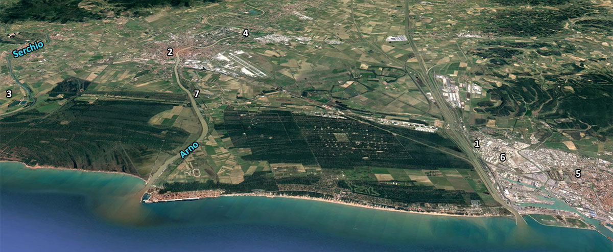
After a little research it soon becomes apparent that ‘the’ port of Pisa does not exist. Through the centuries there was a network of harbours and landing-stages around Pisa, probably partly functioning next to each other and partly replacing others. In ancient times the rivers Arnus (current Arno) and Auser (today Serchio) came together in Pisa and flowed as one river to the coast, thus connecting the hinterland with the sea.
The harbour network of Pisa consisted of many sea and river ports and mooring places, such as around the Migliarino island (north of the mouth of the Arno), San Piero a Grado (at the mouth of the Arno), the city harbour of Pisa, Portus Pisanus in Livorno to the south of the Arnus and several smaller berths (see fig.1). Partly due to the changing course of the rivers through the centuries only some of the river ports have been found. In addition to the city port mentioned already, a rivier berth has been found to the east of Pisa on the right bank of the Arno at Campo.
in the first half of the 18th century 1
Little was still known about any old seaport. The only seaport was a harbour described by Strabo 2 in the first century AD. According to Strabo, Pisa was at his time located 20 stadia 3 from the coast, and the river was difficult to navigate for large ocean-going vessels. Perhaps that was the reason why Pisa, next to the river port in the city, needed a more accessible port on the coast, a port that was given the name Portus Pisanus.
The Roman poet Rutilius Namatianus, who travelled in the fifth century AD by boat from Rome to Gaul (modern France), visited various ports, including Portus Pisanus 4: “From there we made for Triturrita: that is the name of a residence, a peninsula lying in the wash of baffled waves. For it juts out into the sea on stones which man's hand has put together, and he who built the house had first to make sure building ground. I was astonished at the haven close by, which by report is thronged with Pisa's merchandise and sea-borne wealth. The place has a marvellous appearance. Its shores are buffeted by the open sea and lie exposed to all the winds: here there are not sheltering piers to protect any inner harbour-basin capable of defying the threats of Aeolus. But, fringing its own deep-water domain, the tall sea-weed is like to do no damage to a ship that strikes it without shock; and yet in giving way it entangles the furious waves and lets no huge roller surge in from the deep". Further on he wrote 5: "So then I moor my ships in the safe anchorage, and myself drive to Pisa by the road the wayfarer goes afoot".
Portus Pisanus is also mentioned in the Itinerarium Maritimum of Antoninus Augustus, a travel guide from the fourth century AD:
a Vadis portu Pisano mpm XVIII" (from Vada to Portus Pisanus: 18 miles [~14 nautical miles]);
"a portu Pisano Pisis, fluvius, mpm VIIII" (from Portus Pisanus tor Pisa via the river [Arno] 9 miles [~7 nautical miles]) 6
But let us first delve more into the background of the region around Pisa.
History of the area around Pisa
According to the German art historian Rudolf Borchardt 7, Pisa, the port city in the delta of the rivers Arno and Serchio, should have been already 5,000 years ago a city flourishing economically through the trade with Spina (a Greek port in the Po delta, the current Comacchio near Venice), especially in amber. In 283 BC Pisa was called a Civitas Foederata (Federal State) within the Roman Empire and in the second half of third century BC it became a naval base for the Roman expeditions to Sardinia and southern Gaul (France). About the same time, a road was built between Rome and Pisa, the Via Aurelia Vetus. In the second century BC Pisa played a decisive role as a military base during the war against the Ligurians.
In the context of this war two new cities were built. In 180 BC Pisa donated a portion of its northern territory for the foundation of the Latin colony Lucca and, when finally the Ligurians in northwestern Tuscany had been defeated, the Roman port city Luna was built. Both ports, the port of Pisa as well as Luna, became a strategic base for the Roman expansion in the western Mediterranean area. The two ports also played an important role in the military advance from Rome to the North: to Pisa along the via Aurelia vetus and a new coast road, called the via Aurelia nova, and to Luna and the Po plain along the via Aemilia. Later, during the Roman Empire, activities in Pisa increased enormously and the city became one of the most important ports for trading as well as for the military fleet of Rome.
Partly due to recent geological and archaeological research, the interest for the port network around Pisa increased strongly in the last years, so that we slowly learn more and more about the harbour system of Pisa.
The Pompeii of the sea
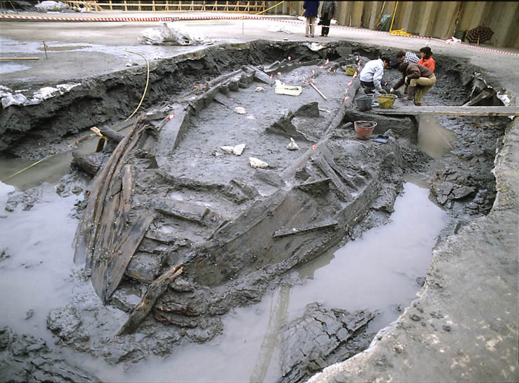
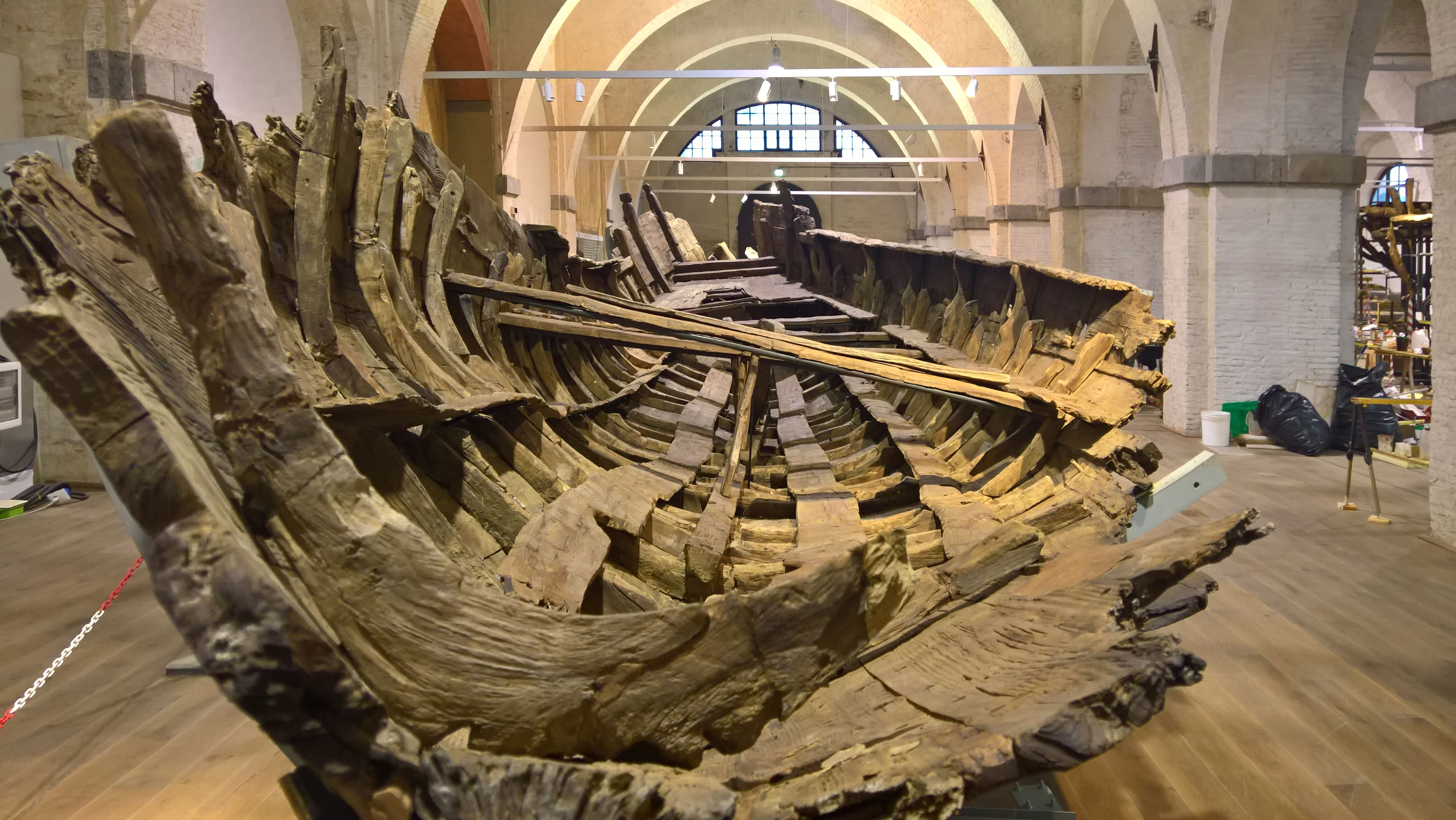
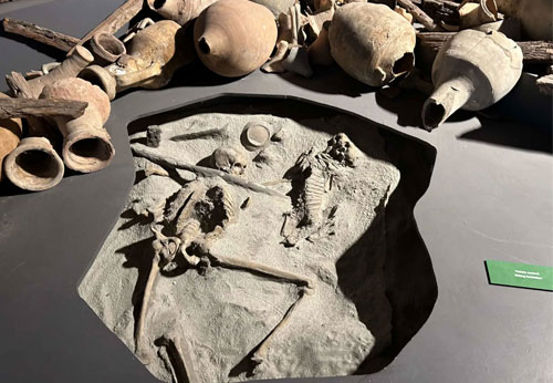
It all started in 1998, during the construction of the new business centre of the railways in the centre of Pisa. A few hundred metres away from the famous tower, near the station of San Rosorre, one and a half kilometres away from the sea, several ships from the Roman time were found. During the following excavations a wealth of objects has been unearthed, including ceramics, amphorae and a number of objects that had to do with the daily life and traffic within a port. Ropes and rigging, fishing equipment, navigation instruments, anchors in stone, wood and iron, baskets and pots. Objects that either had to do something with the cargo or with the equipment of the ships visiting the port of Pisa and which, for some reason, ended up at the bottom of the port. Even wooden and leather sandals, bags and aprons have been found. The archaeologists also found the bones of several sailors and animals. Noteworthy is the discovery of the skeleton of a sailor and his dog. The number of finds was so big that people started to talk about the ‘Pompeii of the sea'. The first wreck the excavations revealed was a roman cargo ship, preserved in excellent condition.
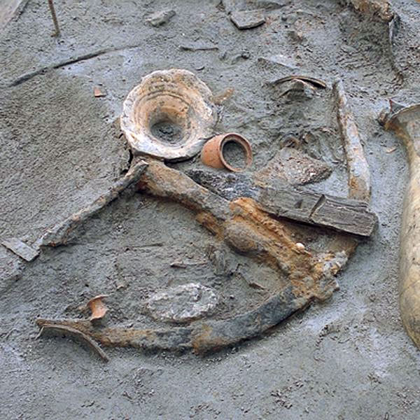
It seemed an isolated case, but further excavations - conducted under the supervision of the 'Archaeological Heritage of Tuscany' - led to the finding of other wrecks, all in very good condition, with part of the cargo still on board. Also the remains of port structures have been brought to light, amounting to at least 39 wrecks from different periods. The longest measures thirty meters. The ships date back from the 2nd century BC to the 5th century AD. In an article, published in the news magazine Newsweek of 11 January 2007, Barbie Nadeau gives us her explanation of why so many ships from various times in history perished with all hands in the port of Pisa. Research apparently revealed that the coast of Tuscany was plagued every few years by a tsunami (caused by earthquakes). These tsunamis could have reached the port city by the channel that connected the city with the coast and wreaked havoc with the ships 9.
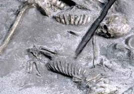
and his dog 10
However, the most important result of this excavation site is that now the city port of Pisa has been mapped out. This port, from which until now nobody knew exactly where it was located, was part of the complex of ports and waterways that were connected to the Portus Pisanus.
Portus Pisanus
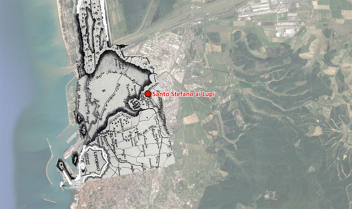
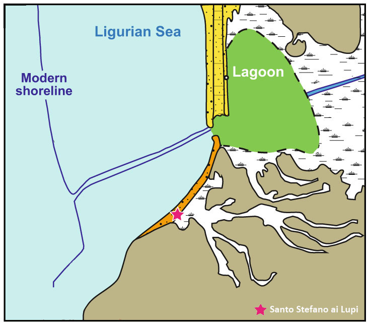
In 56 BC Cicero 11, in a letter to his brother 12, mentioned a port called Portus Labro, probably located in the same area as Portus Pisanus. Was Portus Labro perhaps an earlier name for Portus Pisanus or was this another port? For the time being we must leave this question unanswered. Portus Pisanus itself must have been in a lagoon at the mouth of the current drain of the Arno ("Scolmatore"), to the northwest of the ancient city of Livorno, which is probably today’s northwest part of the city (see fig. 2).
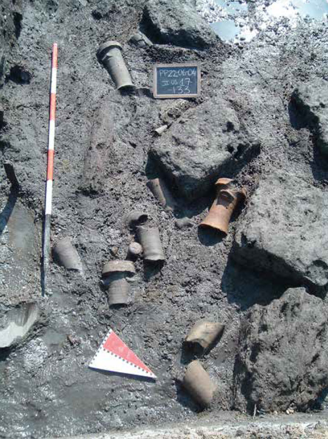
Archaeological excavations at Santo Stefano ai Lupi corroborate both the classical sources and Targioni Tozzetti’s (see fig. 2) description with the discovery of portions of seabed covered by fragments of ancient pottery (dated to the 6th–5th centuries BC and to a period between the 1st century BC and the 6th century AD), ballast stones, part of a small stone dock, and some buildings, including a warehouse and a necropolis dated to the 4th–5th centuries AD. These structures belong to the Portus Pisanus harbour system.
Unfortunately only a small area of the ancient port city and the adjacent basin has been excavated. The pottery fragments found on the ancient seabed prove that, in this part of what was called Portus Pisanus, boats and ships were loaded and unloaded. Presumably the corresponding harbour basin offered natural protection to the ships. Neither historical sources nor archaeological research have shown artificial breakwaters, so we can assume that the associated harbour basin was indeed a large, naturally sheltered bay.
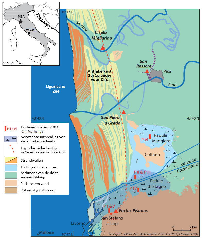
A team of geologists and archaeologists from France, England and Italy has recently done research on the environment and the sea level from the Holocene until now (the last 11,000 years) 14. Their research showed that in 200 BC the port, located about 20 kilometers south of Pisa, lay in a lagoon with natural protection and easy access to the city of Pisa, which benefited the trade and shipping and was suitable for the establishment of port facilities. In addition they found charcoal fragments (often an indication of human activity) and remains of shipwrecks. By linking the findings to old maps and writings, they could complete the reconstruction.
The lagoon offered good shelter to Portus Pisanus, the port of Pisa, far into the fifth century AD until the lagoon’s access disappeared around 1000-1250 AD because of the shifting of the coastline (see fig. 9). Around 1500 the lagoon was completely cut off from the sea and changed into a lake. By then the port activities had already been moved to a new port in current Livorno.
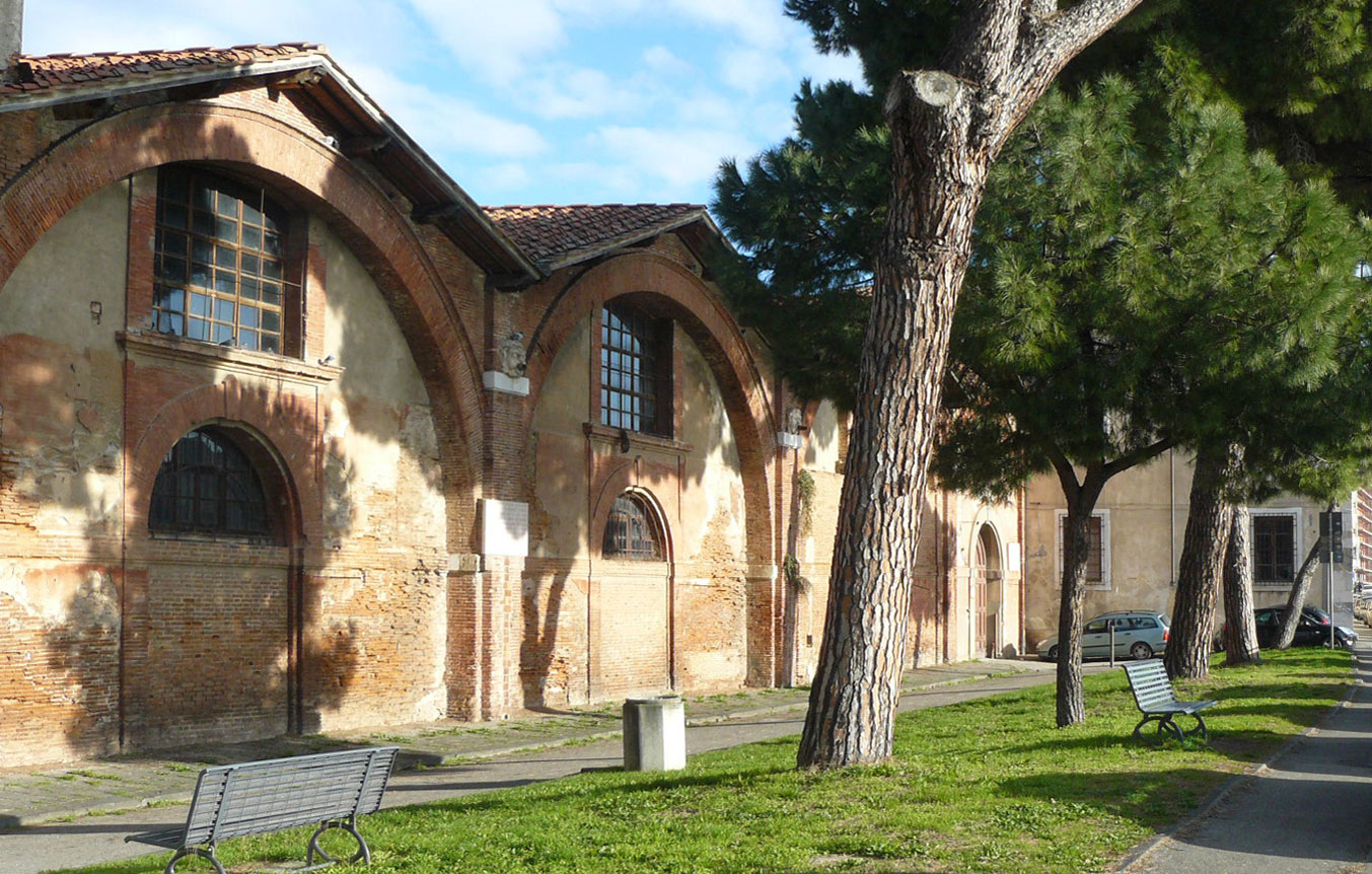
The museum of the ancient ships in Pisa
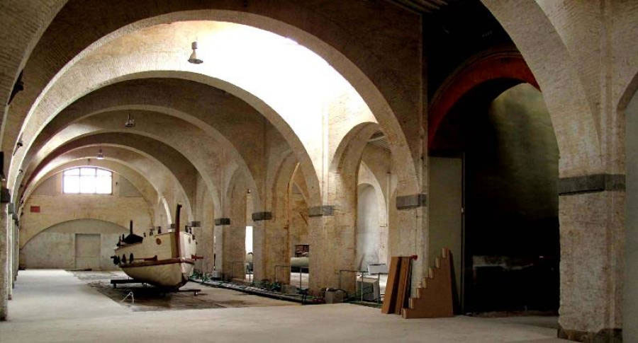
The museum 15, covering an area of 5,000 m2, will mainly show the finds of the excavations in the city centre. Among these are the remains of 39 ships from the 2nd century BC till the 7th century AD. The museum is a combination of the Centre for the restoration of wet wood, the preserved remains of the ancient ships and the recently renovated 'Arsenal of the Medici'. This arsenal was built by Cosimo I as a shipyard in Pisa for building ships for the Tuscan fleet.
- Sources
- - Marinella Pasquinucci: An efficient communication network: Roman land, sea and river routes in north-western Etruria.
- - Holocene evolution of Portus Pisanus, the lost harbour of Pisa.
- - Arthur de Graauw, www.AncientPortsAntiques.com.
- - Nature Eurasia, August 24, 2018.
- - Behind the tower. The ancient ships of Pisa..
- Notes
- 1: Map of Targioni Tozzetti, 1768-1779.
- 2: Strabo was a Greek historican, philosopher and geographer who lived from 64 BC till 23 AD.
- 3: Stadium (plural stadia): originally a Greek length measurement. 1 stadium is about 185 meters or 1/10 nautical miles.
- 4: Rutilius Namatianus in 'De reditu Suo': inde Triturritam petimus: sic villa vocatur, quae iacet expulsis insula paene fretis. namque manu iunctis procedit in aequora saxis, quique domum posuit condidit ante solum. contiguum stupui portum, quem fama frequentat Pisarum emporio divitiisque maris. mira loci facies: pelago pulsatur aperto, inque omnes ventos litora nuda patent; non ullus tegitur per bracchia tuta recessus, Aeolias possit qui prohibere minas; sed procera suo praetexitur alga profundo molliter offensae non nocitura rati, et tamen insanas cedendo interligat undas nec sinit ex alto grande volumen agi.
- 5: puppibus ergo meis fida in statione locatis ipse vehor Pisas qua solet ire pedes.
- 6: Also because of these distances scientists believe that the location of Portus Pisanus was in a suburb of modern Livorno.
- 7: Rudolf Borchardt: Pisa. Ein Versuch. Zürich 1938. Neuausgabe 1948.
- 8: Photo: www.pisaconguida.it.
- 9: https://www.newsweek.com/nautical-pompeii-found-pisa-96429. Until now nobody has endorsed this hypothesis. Besides the tsunami-theory several other causes are possible.
- 10: Photo: Perdita Phillips.
- 11: Marcus Tullius Cicero was a Roman orator, politician, lawyer and philosopher who lived from 106 till 43 BC.
- 12: Ad Quintum fratrem 2,5.
- 13: Illustration: https://www.nature.com/articles/s41598-018-29890-w.
- 14: D. Kaniewski, N. Marriner, C. Morhange, M. Vacchi, G. Sarti, V. Rossi, M. Bini, M. Pasquinucci, C. Allinne, T. Otto, F. Luce & E. Van Campo.
- 15:https://www.navidipisa.it/.


 We are committed to providing versions of our articles and interviews in several languages, but our first language is English.