By Cristiano Fiorentino
Preface
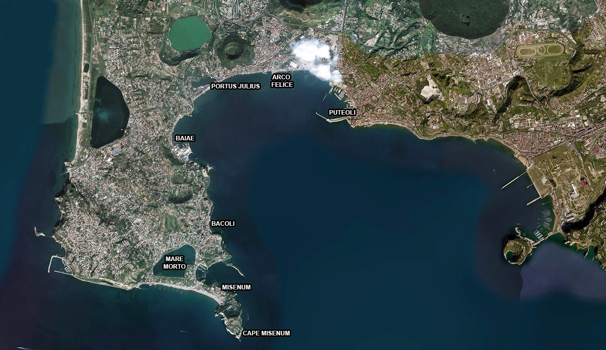
Campi Flegrei (fiery fields) is actually part of a caldera (super volcano formed in this case by 24 craters) to the west of Naples and constitutes the western margin of the Campania plain. Most of the volcano is located in the Gulf of Naples and is submerged. Here, Ischia and Cuma were the first Greek colonies in Italy. The Roman dominion began only from the 4th century BC. The area was still quite inaccessible due to the presence of the forest called Silva Gallinaria, where many bandits and outlawed people sought refuge. Furthermore, as in Ostia, marshy environments and marshes were also a source of malaria. With the demolition of part of the forest new residential communities were founded. Here the Romans built several ports, including that of Puteoli (now Pozzuoli), located between Cuma and Naples. This is an article about the ports of Campi Flegrei.
The civil port of Puteoli
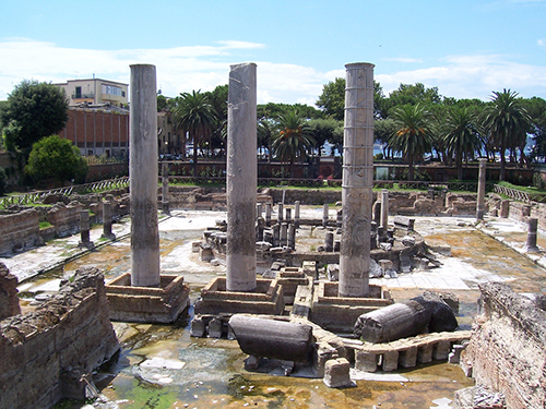
Puteoli was, before the birth of the port of Trajan in Portus 2, the main port of Rome and consequently the city benefited incredibly. Here the spices, slaves, wine, ceramics, and precious objects destined for the Roman market converged from every side, above all the grain for the annona of Rome, brought every year by the Alexandrian fleet (classis Alexandrina), and initially preserved in huge warehouses that extended from the current port area of Pozzuoli to Arco Felice, along the Puteolan shore, ready to be subsequently sorted and transported to the capital.
The construction, which in this majestic form dates back to the Augustan age, was damaged by a storm at the time of Hadrian, and the promise to restore it, made by the emperor, was fulfilled by his successor Antoninus Pius in 139 AD, as recalled by an inscription found in the water of the port: opus pilarum vi maris conlapsum a divo patre suo promissum restituit 3.
The decline of the port of Puteoli
With the birth of the new port of Trajan in Portus, Puteoli lost the primacy, following the gradual transfer of the Alexandrian fleet to a place much closer to Rome. However, in Puteoli remained an important role in contacts with the African coast. Subsequently for the port a long period of decay began, both because of scarce frequentation, and because of the problems of silting due to the bradyseismic motion 5, and, obviously, due to the serious crisis that struck the empire, leading to its total abandonment, in the period between the end of the Western Roman Empire until the end of the Middle Ages.
The Portus Iulius and the port of Baiae
The construction of the Portus Iulius was desired in the area between the lake of Averno and the Lucrino basin by the collaborator of Octavian M. Vipsianus Agrippa, in 37 BC in the context of a naval battle against Sextus Pompeius who had dominion over the seas.
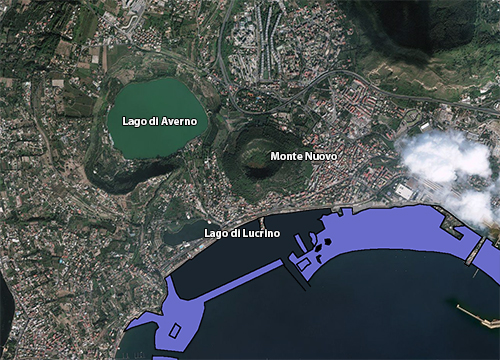
Construction work on the relative infrastructures was entrusted to the architect Lucius Cocceius Auctus. In ancient times the port was defended by a narrow and long dam, thrown on the beach, which started from the Punta dell'Epitaffio and connected it with the Caruso tip, on which the Via Herculanea passed. In the dam there was a channel that allowed the entry of ships into the Lucrino basin and from here, with another channel dug into the rock, into the lake of Averno.
The military life of this port was short. Due to the silting up already in 12 BC, the military fleet was moved to the nearby natural basin of Miseno and the port was converted for civil purposes. The area, after the military interval, returned to be a sacred place of the infernal divinities and to thermal treatments, as well as a place of luxurious residences.
The military port of Misenum
The port of Miseno (Misenum) was located at present Bacoli and the homonymous Capo Miseno, similar in set-up to Ravenna. It could hold at least 250 ships, like the one in Classe in Ravenna. In the Augustan age, following the impracticability of the previous port of Milia Portus Iulius in the bay of Puteoli (used by Octavian through Agrippa during the war against Sextus Pompeius), the nearby Miseno became the most important military base of the Roman fleet to guard the western Mediterranean basin.
The lake of Bacoli called Maremorto
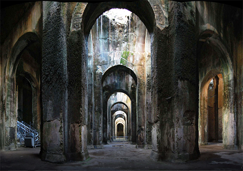
The port exploited a double natural basin, the innermost one of about 3 km in circumference (called Maremorto or Lago Miseno), in ancient times dedicated to shipyards and naval maintenance, and the outermost one, which was the actual port. Between the two basins the historians have imagined there were naval systems and barracks of the Classis Misenensis. Next to the port, the huge tank called Piscina Mirabilis was the main water supply for all military ships.
The ships of the fleet remained safe in the base in autumn and winter. Navigation began on March 5 with the festival called Isidis Navigium in honour of the Egyptian goddess Isis, patroness of the sea, sailors and seafaring activity. The fleet also had detachments in the main Mediterranean ports, such as in nearby Centumcellae (Civitavecchia), in the Aegean Sea at Piraeus (Athens), or in the Adriatic at Salona.
The later history of the ports
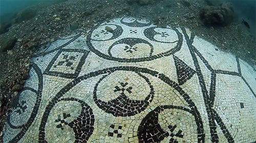
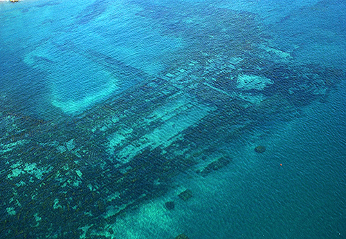
The fate of the port infrastructures in the following centuries are linked to the bradyseism. Cassiodorus informs us that at the end of the fifth century the breakwater of Portus Iulius was destroyed. The following centuries witnessed the complete disappearance under water of the dam and of all the ancient structures, so much so that the Lucrino basin was unified with the sea. In a document of 1503, regarding some movements due bradyseism, De Lorio wrote: "the sea dried up bringing out some 'pilae'." The phenomenon of lifting of the coast continued up to the eruption of Monte Nuovo on September 29 of 1538, which determined the disappearance of the village of Tripergole and reduced the Lucrino lake to little more than a pond. Portus Iulius was brought to the attention again at the end of the last world war, thanks to aerial photography and the first photos taken by the pilot, as well as the diver, Buchner, which highlighted the topography of the large port complex that extends over an area of about ten hectares (see the video).
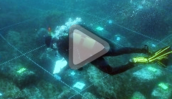
The aerial photography had the merit of sensitizing scholars and the Superintendency. The latter, prompted by the aerial images, issued the first protective measures by launching some underwater campaigns aimed at both the actual survey and the study of the great port complex. The survey and the study of the structures, for the moment, concerned only the eastern part of the complex and more precisely the part in front of the 'Lido Augusto', which consists of buildings used as warehouses built of opus reticulatum 9, that rise from a few centimeters up to about one meter, overlooking a central courtyard, and a manor with a peristyle of brick columns located on the west side of the warehouses. The vast majority of the complex, unfortunately, has not yet been the object of survey, all the graphic elaborations have been derived from photo-interpretations.
The port of Baiae was a civil dock mainly reserved for the wealthy personalities and politicians who frequented the thermal complex of Baia: like the port of Julius, it also had a dam with a canal to protect the landing places.
Related: http://www.archeoflegrei.it/
- Notes
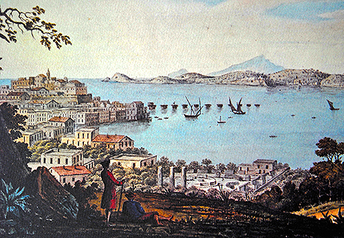
- 1: Campi Phlegraei-Naples, drawing by Sir William Hamilton from 1776.
- 2: Trajan built his harbour at Portus more inland, behind the harbour of Claudius. The latter was relatively open to the sea and caused much trouble by stormy wheather.
- 3: Translation: He restored the pillars destroyed by the force of the sea, according to the promise of his divine father.
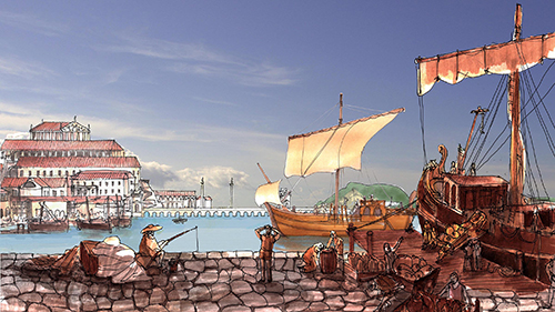
- 4: Artist's impression made by the author.
- 5: Bradyseism is the gradual increase or decrease in a part of the earth’s surface by filling or emptying of underground magma chambers of a volcano.
- 6: Photo: Ferdinando Marfella.
- 7: Photo: Tower Life (Octavia Drughi).
- 8: Photo: Archivo Soprintendenza Speciale per i Beni Archeologici di Napoli e Pompei.
- 9: Opus reticulatum: a building system consisting of small diamond-shaped tuff stones.


 We are committed to providing versions of our articles and interviews in several languages, but our first language is English.