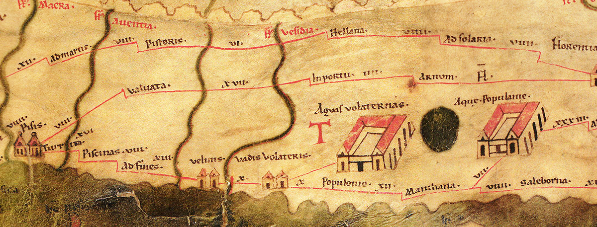
Entering on the region of Volaterra, appropriately called "The Shallows," I thread my way through the deep part of the treacherous channel. At the bow the look-out watches the water beneath and gives directions to the helm beyond, guiding the stern with warning shouts. A boundary on each side marks puzzling narrows by a pair of trees, and presents a line of piles hammered in there: to these it is the custom to fix tall laurels easy to see because of their branches and bushy foliage, so that, although the shifting bank of thick mud shows its mass of sea-weed, a clear passage may keep the guiding-signs unstruck. There I was driven to make a halt by a tearing North-wester of the sort that is wont to shatter the depths of the woods. Scarce safe beneath a roof did we endure the pitiless rains: the neighbouring country-seat of my own Albinus was placed at my disposal.2
With these words the Roman imperial poet Rutilius Namatianus described in 5th century AD in his De Reditu Suo3, his arrival at the port of Vada Volaterrana. Not only Namatianus mentioned this port, also other classical writers, like Cicero and Plinius wrote about the place which, perhaps because of its marshy position, was first called Vada and later on, in the Roman republic, Vada Volaterrana as part of the the Volterra district, which probably extended from this high up to the small river which still bears the name Fine4.
Volaterrae
Volaterrae, modern Volterra, was one of the most important Etruscan cities, located in the core of Tuscany, on top of a naturally defended and protected high promontory.
From the 8th century BC, the first villages inhabited by the Etruscans began to develop and from the 6th century BC this villages became a real city with stone walls and temples and even an own mint. In other words, a new political community.
During these centuries the city of Volaterrae was able to establish its power over a vast territory, rich in mineral resources and salines. The city was connected to the coast by means of the Cecina River valley, which in ancient times was the main trade route to the Mediterranean Sea.
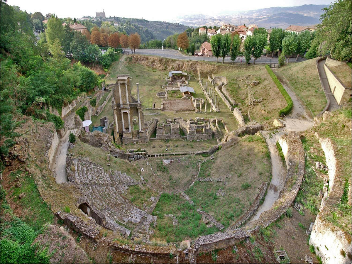
At the beginning of the 3rd century BC the city, like all other Etruscan states, fell under the rule of Rome. The decades since Volaterrae became an ally of Rome were profitable for the city and its countryside, especially towards the end of the Republic when Octavian gave land in Etruria to veterans after the battle by Actium (31 BC). The city was enriched with a theater, thermal baths and many houses had decorated mosaic or marble floors and painted plaster, which hint at the prosperity the area experienced5.
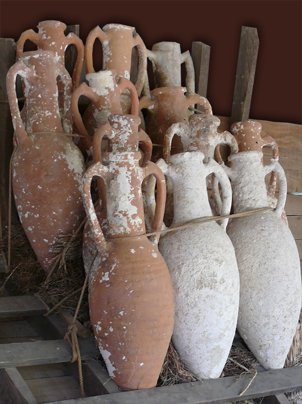
Along the coast, the lords of Volaterrae built their villas and developed the production of wine for exportation in amphoras as far as the Western provinces of the empire.
The hinterlands around Vada Volaterrana were also densely populated, hosting six centers for producing wine amphorae of the Dressel 1 type, bricks, and other pottery. These were spread via the nearby Via Aurelia and Via Aemilia.
The Augustan period was one of expansion for Volaterrae and its surroundings. As previously shown in other parts of the Roman Empire, ports and harbours upgraded from their natural states or minimal designs into artificial structures had become a necessity for many important cities. Volaterrae may not have been one of these behemoths, but it acted as the main hub for its hinterland’s residents, and in order to import and export goods it needed to update its own port.
Vada Volaterrana
North and South of the mouth of the river, located inside lagoons and bays open to the sea and well protected from the main sea currents, was a harbour system capable of ensuring the arrival of goods and the export of local products.
The harbour system, called Vada Volaterrana, was positioned between the rivers Fine and Cecina and used both to access its hinterlands. According to the the Itinerarium Maritimum7 the harbour was located 25 miles from Populonia and 18 from Portus Pisanus (see article ‘ The lost harbour of Pisa’). The shores in the Roman period were dotted with smaller landings such as Vada for several reasons, including efficiency and cost. The important aspect of so many similar, smaller sites is their contribution to Mediterranean connectivity.
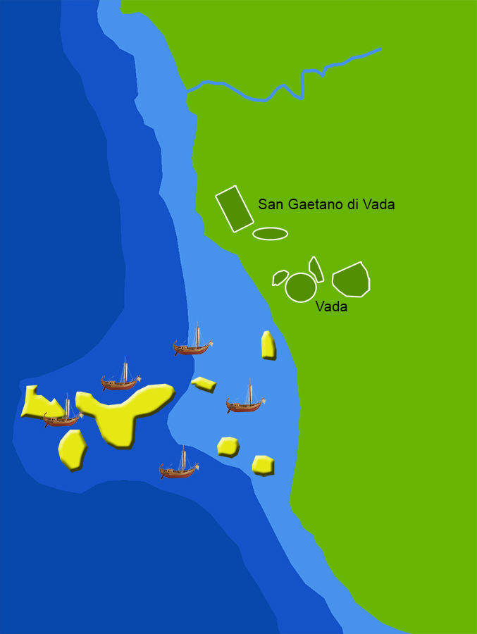
Vada was a known landing place, and with the Cecina and Fine rivers and the nearby road systems Vada was a good candidate to engage in trade for its own hinterlands and into Tuscany all the way to Volaterrae.8 There had always been some form of natural harbour at Vada Volaterrana before the Augustan revitalization. Pliny claimed it was an important stop on the route to Gaul from Italy between 83-81 B.C., and so it is unsurprising that it would be enhanced to suit the growing area’s needs at the turn of the era.
Ancient Vada Volaterrana lies underneath the modern town, though the ancient harbour basin is most likely buried beneath the present-day Solvay company’s jetty, which takes advantage of the area’s good anchorage and protective sand.
As of today, the actual port facilities cannot be examined directly and so we must make inferences from available comparative material. It seems obvious to state that the size of a harbour’s hinterland, and thus of its dependent population and economy, is reflected in the size of its enclosure, wharf length, and warehouses. But the lack of evidence for the size of the harbor enclosure and for wharf length in the case of Vada Volaterrana forces us to look to the use of its warehouse as our only recourse.
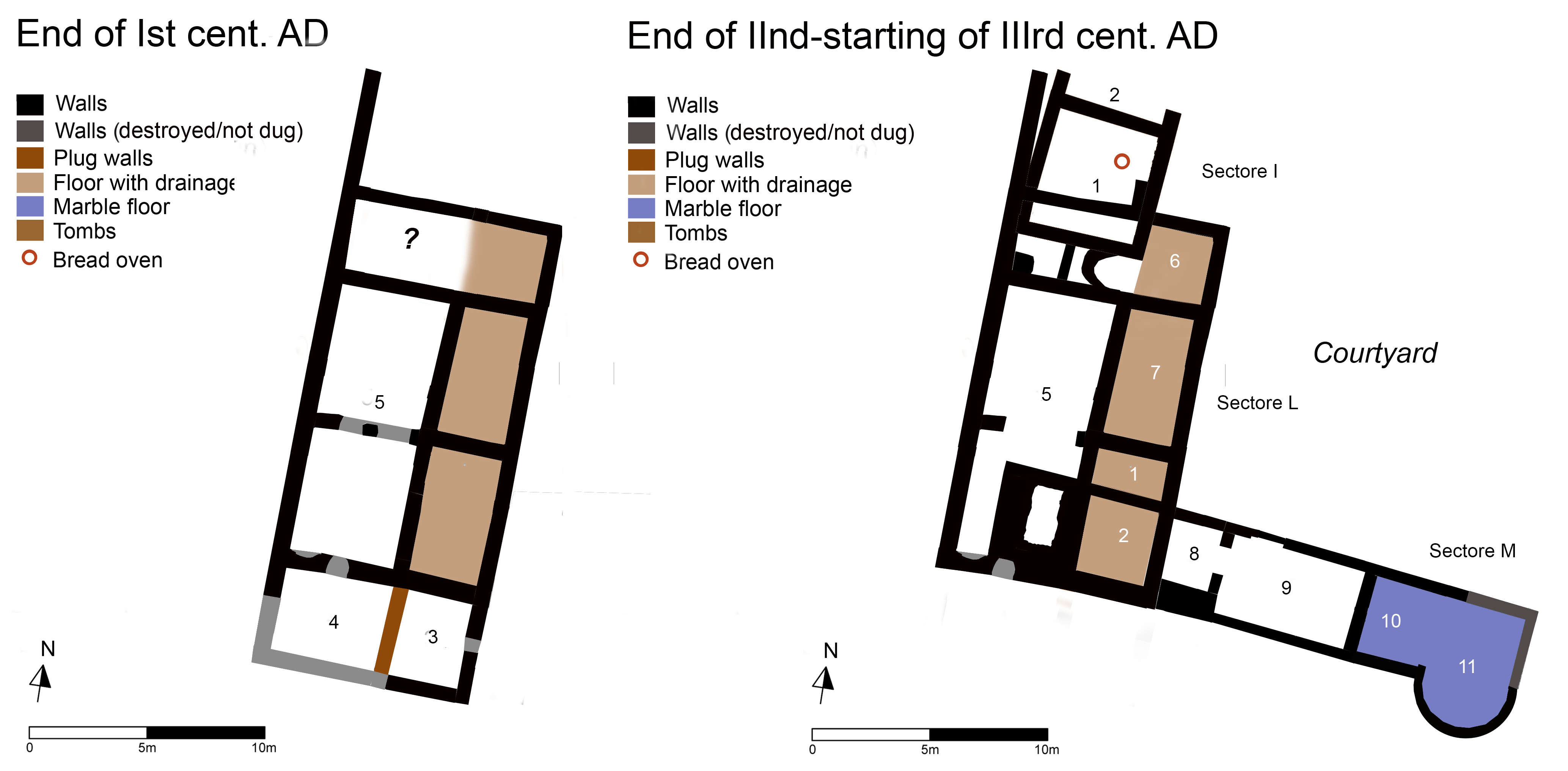
The Vada Volaterrana harbour quarter

The Roman site was built during the Republican era and its ruins lie just outside of the modern city of Vada. In response to the expansion in the Augustan period the port area underwent systematic renovation, which lends credence to the idea that the actual port facilities would have been renovated as well.
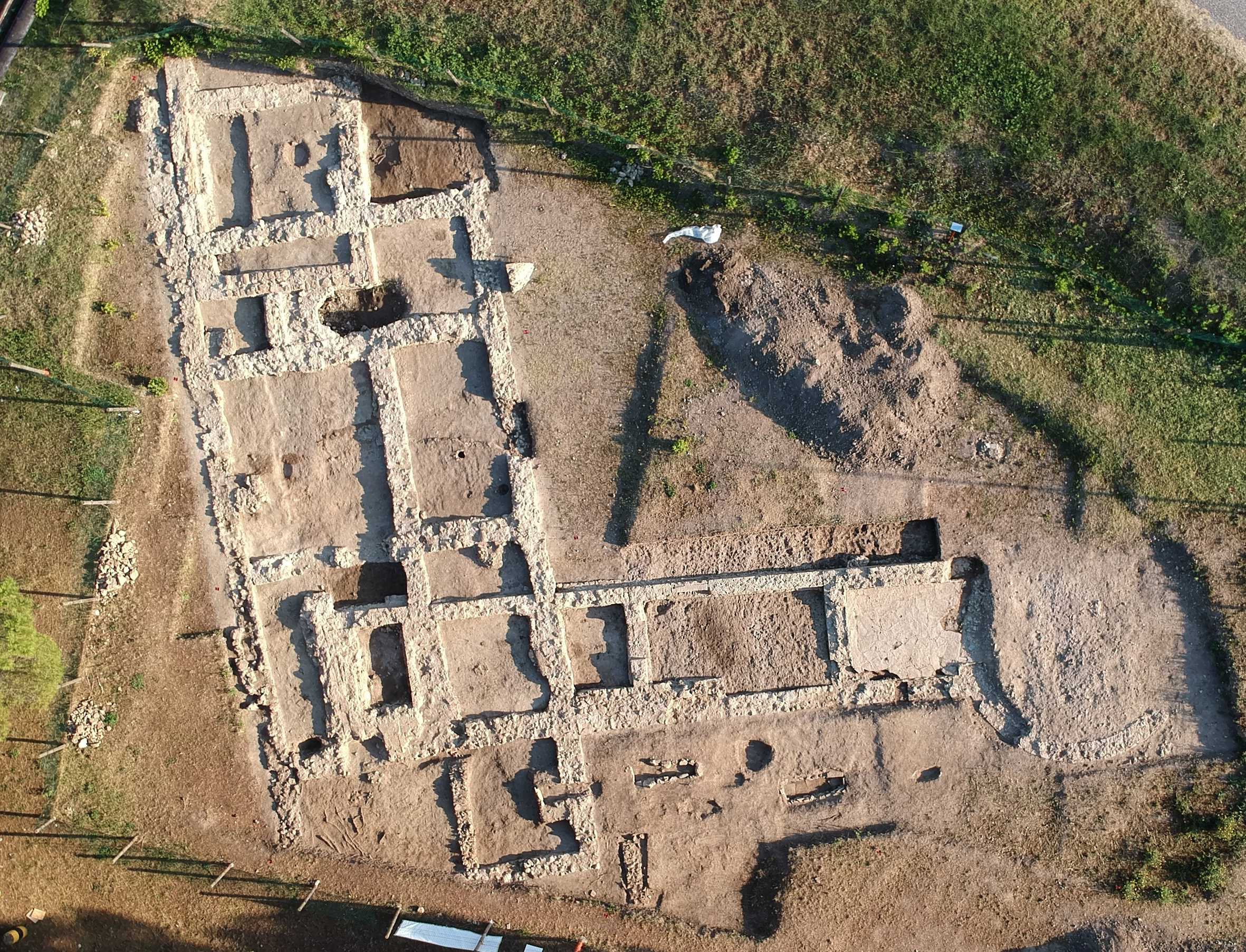
The main harbour in this port system was located further North of the rivermouth called Geatano di Vada. Currently the University of Pisa in conjunction with the Archeo Data Cooperativà conducts since the 80s a field school on the outlying harbour neighbourhood.
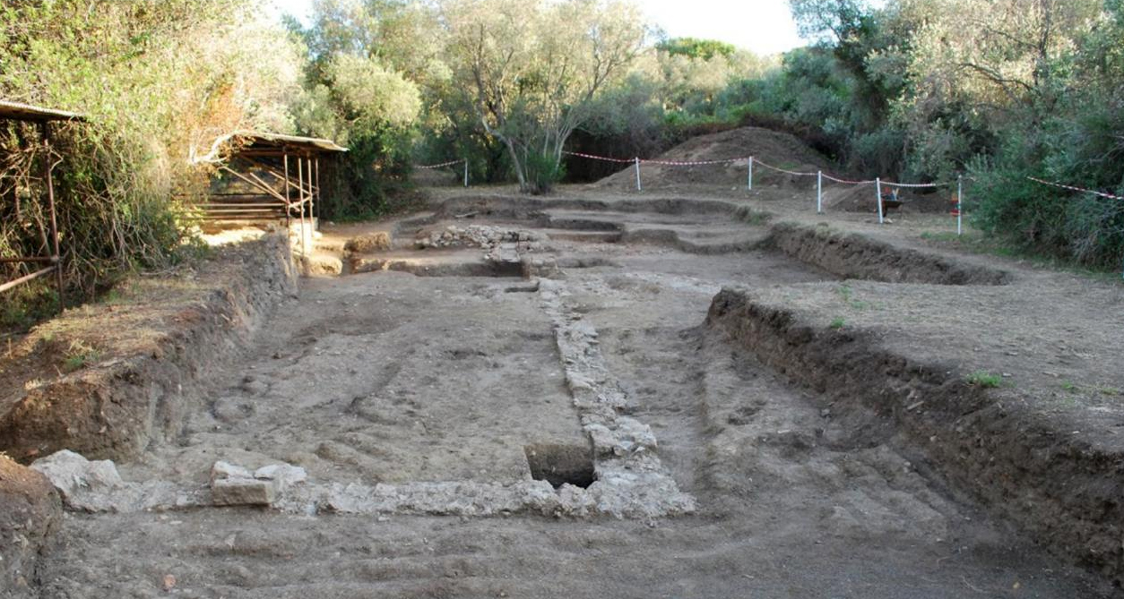
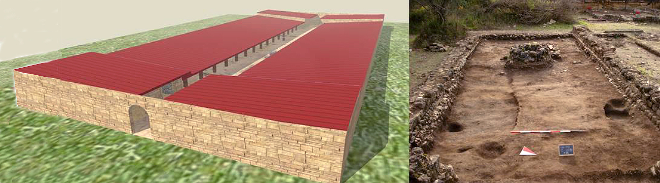
During the past years many buildings have been unearthed within the commercial quarter of Vada Volaterrana: two thermal baths, a large horreum (warehouse) with 36 cells at least, a large water tank, a monumental fountain - used for watering the animals used in transportation of goods at the warehouse - and the head office of the collegium (guild) in charge of port activities management and several still undefined structures. The discovering of these buildings is also of importance because their size and the techniques used to create them may offer direct insight into the lost harbour structures.
Let’s look at the individual buildings.
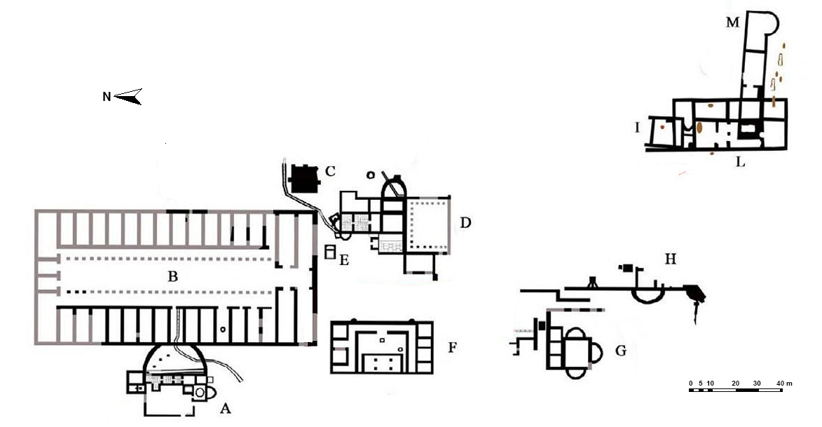
The Small Bath house (A)
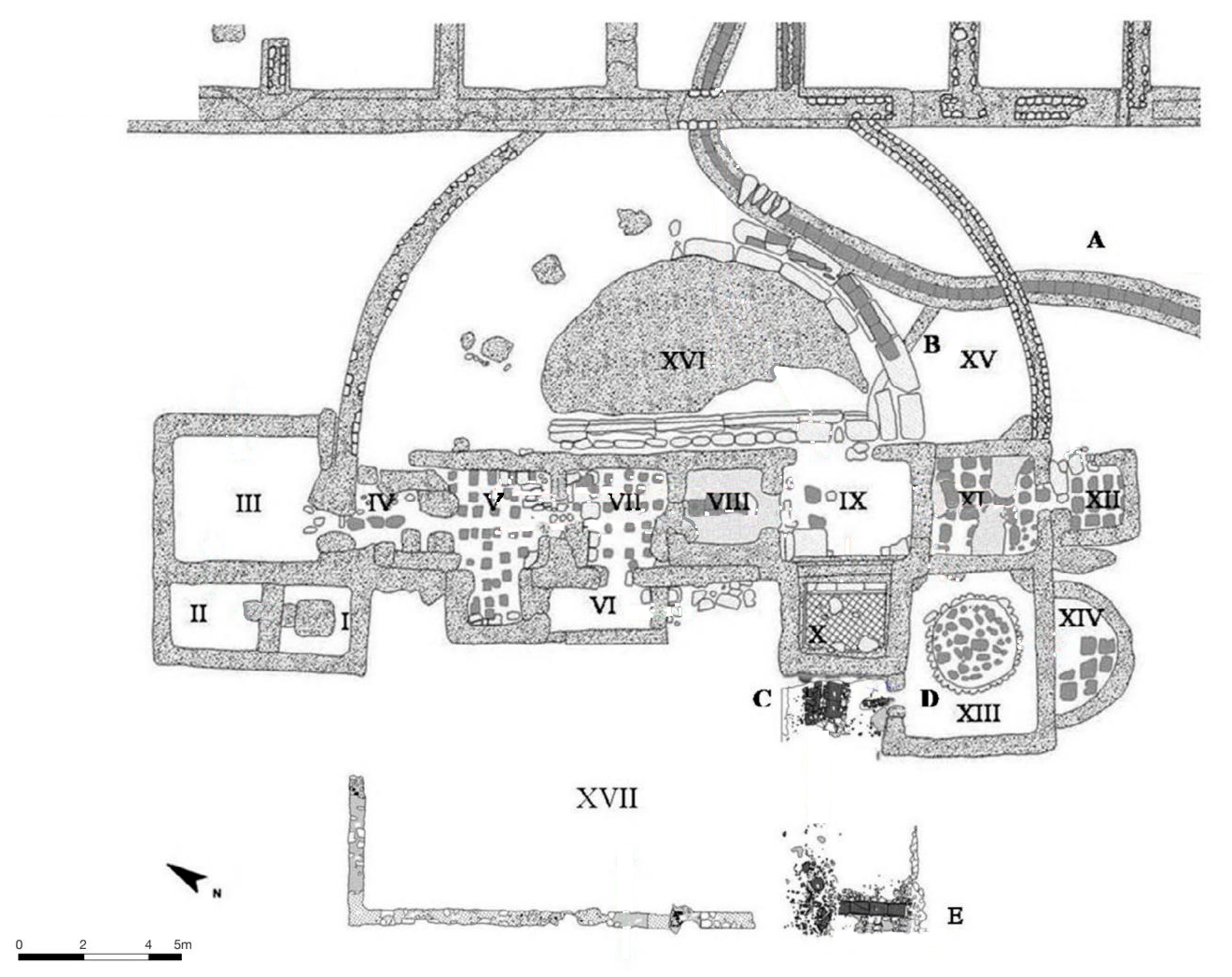
Already in the year 1958 several rooms of this small bath house were brought to light. At the restart in the summer of 1959 other rooms were found from which one equipped with a very interested sunken bath tub with a floor of white mosaic and with exhaust lead pipes.
The bath, built in the early 2nd century AD was structurally and functionally connected with the pre-existing horrea and could only be reached from within the storehouse.
Totally there were 17 spaces. In contrast to the Grandi Terme (D), a public bath house operated by a conductor (leaseholder), the Piccole Terme were private baths for the staff and visitors of the horrea (B).
Room I has a basement made of cement and pebble that occupies almost the entire floor. This floor served as an housing for bronze reservoirs containing hot water. In the east wall we see a housing for a terracotta outlet system that distributed the water to the rooms IV and V, the caldarii (hot water bath).
Room II is a service room mainly for room I. There is a small stair for easier reaching the bronze containers with hot water in room I.
Room III is the praefurnium (furnace) for heating caldaria (hot water baths) IV -V and tepidarium (lukewarm bath) VIII.
Room IV-V is the caldarium in which almost the complete floating floor disappeared. In the rooms have been recognized the spaces for two labrii (water-basins) for hot water, one on the west wall and the other on the north side.
The heated rooms IV-V, VII, VIII an IX had a hypocaust floor10.
Room VI was equipped with a staircase which was the only access to space XVII, a space outside the main building.
Room VII was a room used as caldarium or tepidarium (see the next room).
Room VIII was probably a tepidarium. In this room a nice piece of the marble floor has survived.
Room IX was a vestibule with a floor of Greek marble partly still in situ.
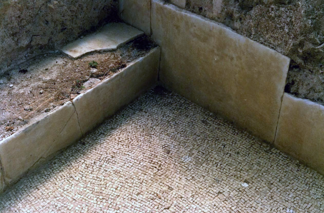
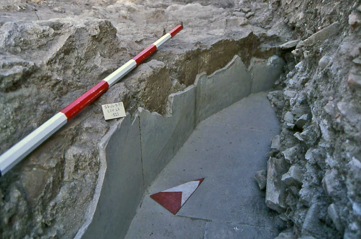
Room X was the only frigidarium (cold water bath) of the complex. The room is occupied with a small tub sunk into the floor with a marble pavement. Along the eastern wall there is a marble bench of 15 cm in height. The marble plates are locked by bronze cramps. The wastewater was removed towards the sea via a canal made from tiles.
Room XI was, considering the hypocaust floor with vertical placed tiles fixed with metal cramps and the direct connection with praefurnium XII, identified as a sudatio (sweat room).

Room XII was a small praefurnium with an entrance for the servants at the west side.
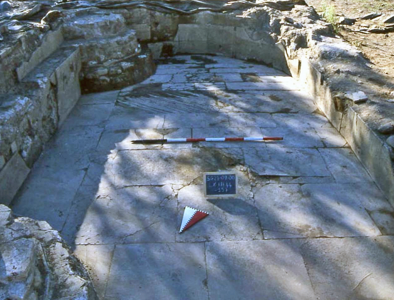
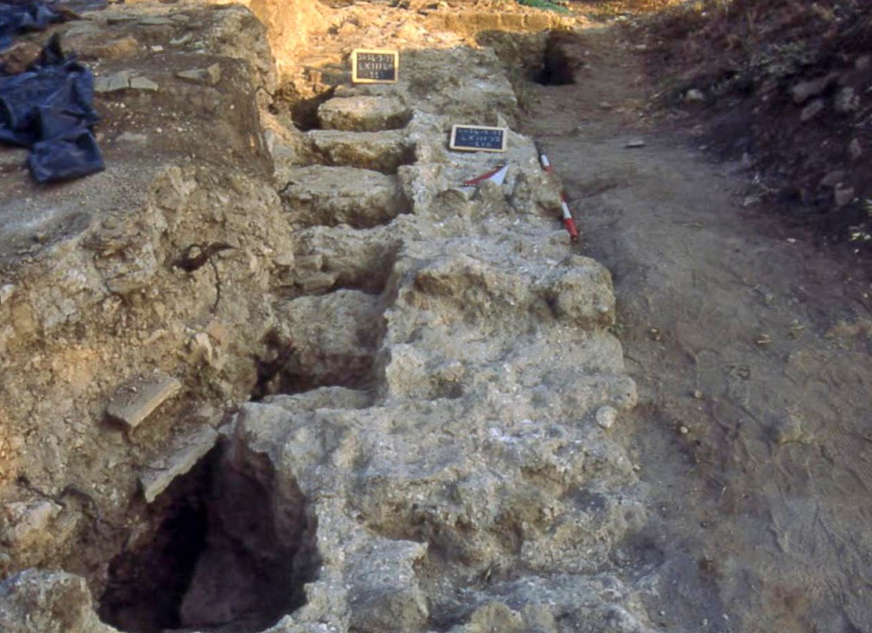
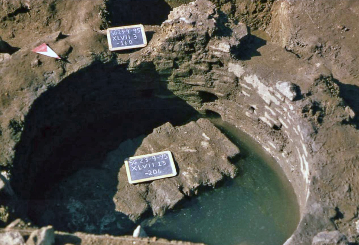
Room XIII (5.10 x 3.90 m) is dominated by a round, 1.5 m deep cistern.
Room XIV is a small room shaped as an exedra against room XIII. The original function is unknown.
Room XV – XVI could be reached from cel 9 of the horrea. Room XV was covered, room XVI was in the open. The last one could have had the function of a palestra/solarium while a small semicircular portico (XV) could be used as a covered ambulation (promenade).
Room XVII is a space outside the bath house complex, but functionally connected. Like in every other bath house also this bath house had a multi functional space for storage of wood, storage of waste, construction material, spare parts etc.
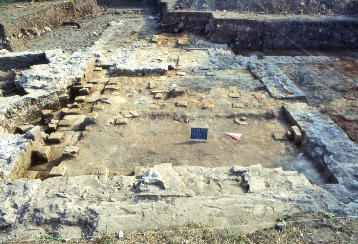
The Horrea (B)
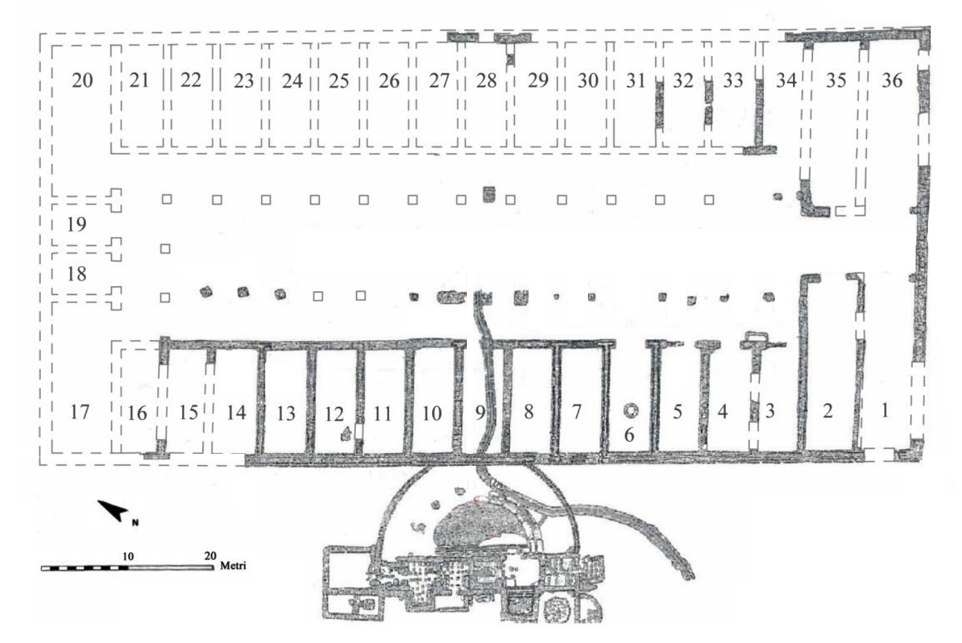
These horrea, dominating this harbour area had 36 cells for storage and was connected with the private bath house A. One could only reach the bath house via cel 9.
The various finds in the horrea, including coins, strongly suggest that this department store complex, probably run by the members of the adjacent guilt of the dendrophori (tree bearers) , was not public but private.
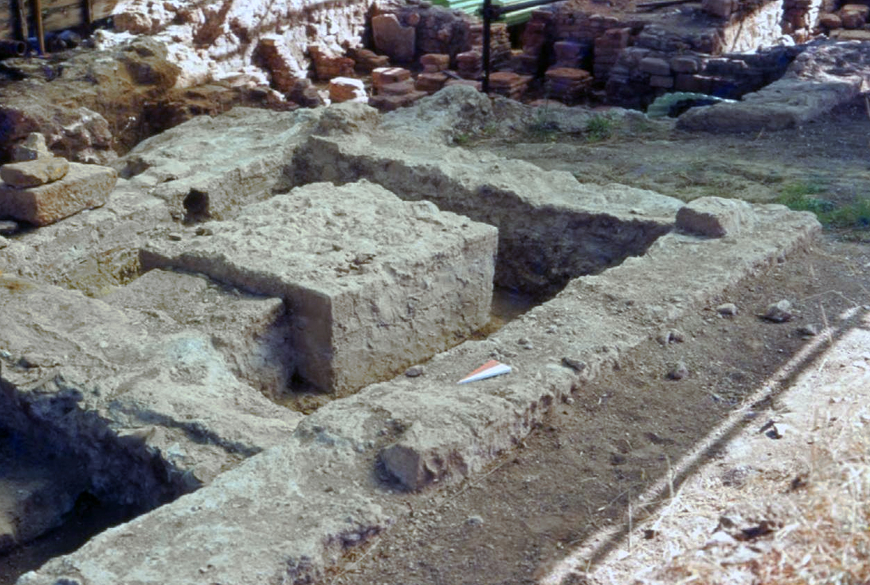
The warehouse, built in Opus caementicium11, was rectangular and ran around a central colonnaded courtyard. Its cells were symmetrical from the east to the west. The entrance was not on the coastline though it did face it. Its entrance was about 1.80 meter, which allowed a moderate flow of goods in and out of the cells. The warehouse primarily held amphorae, which contained wine, oil, garum, foodstuffs, or other goods that have left no record.12
Cistern (C)
This structure has been recognized as an above ground cistern used throughout the entire Neighbourhood14.
The large bath house (D)
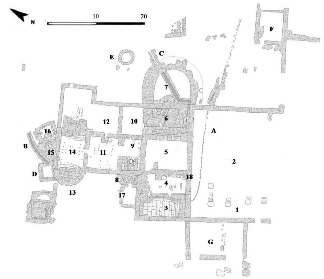
The large bath house of Vada Volaterrana occupies 2.470 m2 and was built as a traditional Terme. It was a public building with a monumental entrance along the main road axis. The building was heavenly affected by agricultural work during the past centuries. Most of the walls are reduced to the foundation. Only the rooms 1, 3 and 13 are in better conditions due to a modern road that was built above these rooms.
The bath house was probably constructed at the beginning of the first century AD. No decorated elements belonging to the baths have been found. Only the tile floor of room 4, vestibulum (porch), in opus sectile is still present as is the marble covering of the floor and the wall of the frigidarium (cold water bath), room 3 (see photo 15).
A lot of floor and wall slabs of Italian and provincial marble have been found out of context.
Going through the arcade palestra (room 1, 2) you entered room 5, a painted quadrangular room probably the apodyterium (dressingroom).
The visitors could pass room 9, the laconicum (sweat bath), with a small exedra on the eastern wall in which the labrum (boiled water tub) was placed (witnessed by parts of the supports and some red spots on the tiled floor).
After the stop in the sudatio (sweatroom) clients could be directed to room 11, the tepidarium (lukewarm bath) and next to room 14, the caldarium (the hot water bath) with two exedrae (13 and 15) probably equipped witch benches to relax. In exedra 13 traces of the marble wall coating have remained.
Both the caldarium and tepidarium had a floating floor for a hypocaustum system (floorheating). The baths were heated by a large preafurnium (fireplace) (room 12) which was connected with space 10 as service-space for the fornacarii (stokers) who could shelter here for the enormous heat in the combustion chamber.
The logistics of the heated rooms asked also for a second, much smaller, preafurnium (room 16) used to heat among others exedra 15. Probably there was also a second sudation.
Returned via the apodyterium you reached the gold water baths, the frigidaria. The eastern frigidarium was constructed as a quadrangular tub with a marble floor (traces are still in situ). Also the water outlet from this bath remained as a leaden fistula (tube) by which the water was transport to an underground tiled channel (C).
From the western frigidarium (3) large parts of the walls have survived. One entered the oval tub via vestibulum 4, from which the floor in opus sectile15 partly has conserved as are the marble walls.
You descend in the tub via two semicircular small stairs with three marble covered steps.
Also from this bath you can still found the leaden water outlet that runs to a small canal (A).
Connected to the bath house, east of the rooms 10 and 12 is a well with fresh water not only for the workers in the bath house but probably also for labor from other workshops east of the bath house.
On the eastside of the vestibulum (4) is a latrine (18).
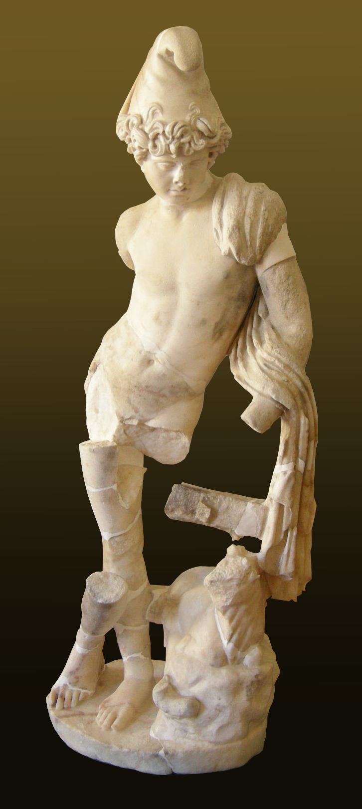
At the end of the 6th /beginning of the 7th century the well was used to dump trash16. Also frigidarium 3 was later used as rubbish dump for heterogeneous materials among which fragments of the statue of the god Attis17 and hundreds of pieces of tubuli (small tubs) and fragments of coloured wall paintings, ceramic and piece of other statues.
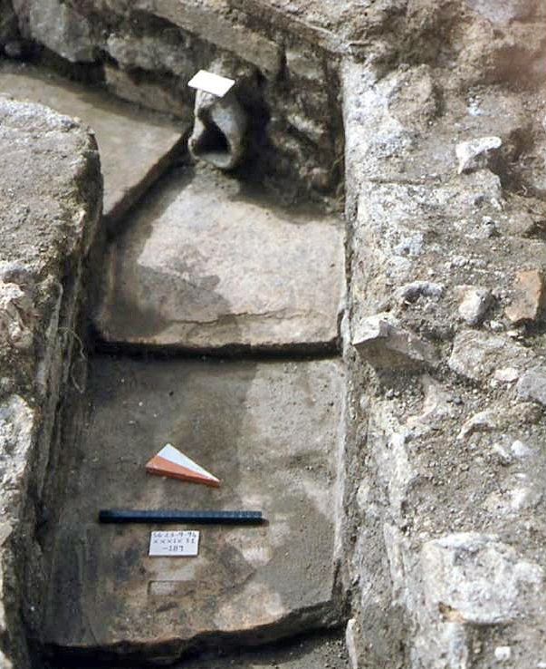
The Fountain (E)
This fountain is located in the immediate vicinity of the entrance of the horrea and is therefore seen as a water place for man and horse involved by loading and unloading of goods.
The Schola (F)
The port quarter included a collegium for guild members who may have run the inner workings of the port, probably the dendrophori (tree bearers)18. They were worshippers of the Eastern goddess Cybele, whose lover Attis’ statue was found in the frigidarium (cold water bath) of the public bath house, where it was intentionally thrown in pieces in Late Antiquity. The statue, dating from the first half of the 2nd century AD, is made of a white marble from Asia Minor. Besides the statue of Attis other cultural aspects were presented in structure F.
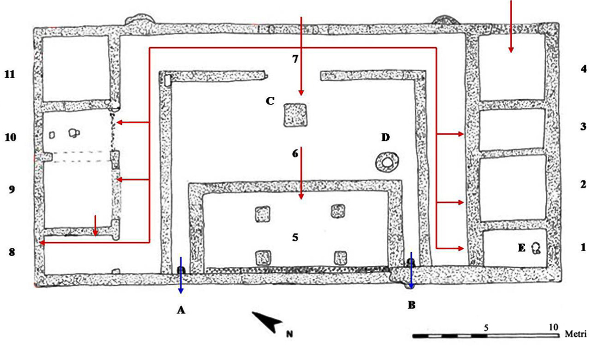
The building measures almost 650 m2 and is symmetrically constructed. The main entrance of 4,5 meter with several arches was located at the eastern side of the building in axes with the entrance of the porticoed corridor (7) to the square structure (C) in the center of the open space(6).
Corridor (7) leading to the rooms 1- 4 at the south side and to room 8 -11 at the north side had painted walls and was delimited by a series of pillars. Alongside the eastern wall were two exedrae. In space 6 we see the stone square structure (C) and a circular well (D). The square room (5) is characterized by the presence of four columns once supporting a second floor and a roof.
Room 8 was probably a service room and 9 and 10 were used for storage. In room 1 there was a pit of 90 cm in diameter with a dept of 84 cm for carbage.
The strati graphs have returned a considerable amount of finds characterized by the substantial absence of transport containers and by the significant presence of quality material. The fragments of ceramics pointed at a foundation date of late Augustan or, at the latest, from the time of Tiberius.
Building G
In the Southern part of this area stands an interesting building dating to the 2nd cent. AD, which purpose is still unknown; three large apses, decorated with remarkable wall paintings, surrounded an open squared courtyard. At first this building was seen as related to the collegium, however, remains of the original style date the building to the first century AD and make it the earliest of the buildings.
Building H
Outside building G, and included in what is called Complex H, is a courtyard containing a basin and a kiln. The building was analysed through GPR. It measured 4 by 5.3m with 90cm thick walls and two large apsidal rooms. Certain readings indicated a water tank or the ruined remains of a stairwell; if there was a stairwell it obviously indicates a second floor. Later discoveries suggested that Complex H, and thus the building, were somehow involved with the terracotta piping to the fountain.
Building I till L
This part of the plant is still being excavated by the field school of the university of Pisa.
At the end of the first cent. AD a big rectangular building was erected in the area currently under excavation, previously empty of any structure. The building, whose function is still unknown, is made of six rectangular rooms. A courtyard was perhaps located next to the Northernmost perimeter wall of the building.
Three rooms have a floor made of more layers of clay mixed with pottery fragments. The attempt to made well drained floors seems to testify the use of these rooms for the storage of food which needed protection against humidity, like corn.
Since 2016 we understood this building underwent more interventions, meant to change its previous plan and – likely – its functions. The most northern room should be a bakery built between the end of the 2nd and the start of the third cent. AD, along with the earlier rooms added to the South-Eastern corner of the rectangular building.
In the Southern sector of the site researches focused on Room 9, whose excavation – started in 2017 – already revealed the presence of a 7th cent. AD metal workshop. After the removal of the workshops layers and structures, we have been able to dig a sunken floor, made of clay, mortar and many small fragments of pottery. The latter allowed us do date Room 9 and other structures located in the South-Eastern corner of the rectangular building – such as the small Room 8 – to the half of the third cent. AD. A lead weight, shaped as a fig, is likely related to the use of the whole area for food trade, already known thank to the bakery dug out in the Northern sector of the area.
Sources- - Le Terme Publiche nell’ Italia Romana (II secolo a.C. – fine IV secolo d.C). Seminario Internazionale di studio, Roman 2018 a cura di Maura Medri e Antonio Pizzo.
- - Vada Volaterrana - Le Piccole Terme da Simonetta Menchelli e Paolo Sangriso
- - Vada Volaterrana – Le Grandi Terme da Simonetta Menchelli e Paolo Sangriso
- -The Vada Volaterrana Harbour project – www.diggingvada.com
- - VADA VOLATERRANA: A COMPARISON OF ROMAN HARBORS AND THEIR PLACE WITHIN MEDITER-RANEAN CONNECTIVITY by Sara Spatafore April, 2017
- - Una schola ai Vada Volaterrana by Paolo Sangriso (Fasti )nline Documents & Research)
- Notes
- 1:Tabula Peutingeriana: ancient Roman road map originally from the 4e/5e century AD
- 2: in Volaterranum, vero Vada nomine, tractum ingressus dubii tramitis alta lego: despectat prorae custos clavumque sequentem dirigit et puppim voce monente regit. incertas gemina discriminat arbore fauces defixasque offert limes uterque sudes: illis proceras mos est adnectere lauros conspicuas ramis et fruticante coma, ut praebente algam densi symplegade limi servet inoffensas semita clara notas. illic me rapidus consistere Corus adegit, qualis silvarum frangere lustra solet. vix tuti domibus saevos toleravimus imbres: Albini patuit proxima villa mei.
- 3: De reditu suo, a Latin poem in elegiac metre, describing a coastal voyage from Rome to Gaul in 416 AD.
- 4: Emanuele Repetti, in his Geographical Physical Historical Dictionary of Tuscany (Florence, 1843)
- 5:Pasquinucci et al. 2012:149;Iacophini et al. 2012:58
- 6: Photo Wikipedia (Ad Meskens)
- 7: The Antonine Itinerary (Latin: Itinerarium Antonini Augusti, lit. "The Itinerary of the Emperor Antoninus") is a famous itinerarium, a register of the stations and distances along various roads. Probably ascribed to the patronage of Caracalla. The Itinerarium Maritimum Antonini is the part describing the seaways.
- 8: Pasquinucci and Menchelli 2005:397
- 9:Laboratorio di Topografia antica, UniPi.
- 10: Hypocaustum: a Roman heating system. Hot air was brought between the basement and a, on small brick columns floating floor (see photo 10)
- 11: Opus caementicium: Roman concrete based on a hydraulic-setting cement.: Lespinasse et al. 1982
- 12:Pasquinucci and Menchelli 2005:395-396
- 13: Photo: Courtesy of Digging Vada Volaterrana
- 14: Tolle. Kastebein 1993, 173.
- 15: An art technique popularized in the ancient and medieval Roman world where materials were cut and inlaid into walls and floors to make a picture or pattern.
- 16: Sangriso, Marini 2010
- 17: Valeri 2017
- 18: This name of Tree-bearers had to do with the pine-tree that was sacred to Attis
- 19: Artwork R. Marchesch


 We are committed to providing versions of our articles and interviews in several languages, but our first language is English.