One of the many port cities in the eastern Mediterranean, present-day Turkey, was Phocea. This port city, Φώκαια in Greek, was founded in the eighth century BC and inhabited by settlers from Athens and Phokis in Greece.
Phocea had two very good natural harbours and, according to the Greek historian Herodotus, was the first seafaring nation to make long sea voyages to the Adriatic Sea, the Tyrrhenian Sea and Spain2. They founded several colonies on their many trade voyages including, around 600 BC, the oldest city in present-day France and one of the oldest continuously inhabited settlements in Europe. They named the city Μασσαλία in Greek, a name that was romanised into Massalía.
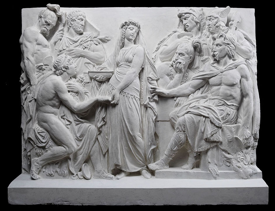
There are several legends about the origins of Massalia but in the 1st century AD this was the most common:
supérieure de beaux-arts, Paris.
So since all the suitors had been invited to the wedding, the Greek guests too were asked to the feast. Then the girl was brought in, and when she was asked by her father to offer water to the man she chose as her husband, she passed them all over and, turning to the Greeks, gave the water to Protis; and he, thus changed from a guest into a son-in-law, was given the site for founding the city by his father-in-law. So Massilia was founded near the mouths of the river Rhone, in a deep inlet, as it were in a corner of the sea4.
This article is about the origins of this port city in Gaul in today's Provence-Alpes-Côte d'Azur region of France, and especially during Roman rule when the city's name was changed from Massalia to Massilia.
History
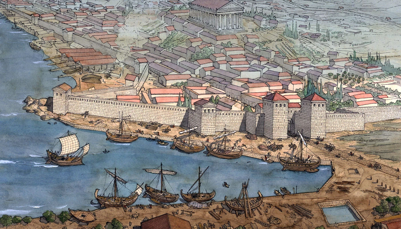
The Marseille area has been inhabited by humans for over 30,000 years. When settlers from Phocea arrived in 600 BC, they were certainly not the first inhabitants on the spot. However, as experienced seafarers, they immediately saw the region's potential for a trading settlement. The Mediterranean inlet of the Lacydon, fed by a freshwater stream and protected by two rocky promontories was a prime spot for a port. Massalia therefore grew into one of the most important trading ports of the ancient world with ups and downs in Roman times.
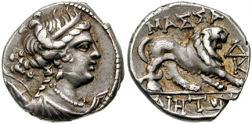
Drachms minted in Massalia were therefore found in all parts of Ligurian-Celtic Gaul. They exported their own products: local wine, cured pork and fish, aromatic and medicinal herbs, coral and cork.
Soon the city flourished through trade with Rome and the rest of Gaul. Massalia's hinterland was hungry for Roman goods and wine and Rome, on the other hand, was in great need of new products and slaves.
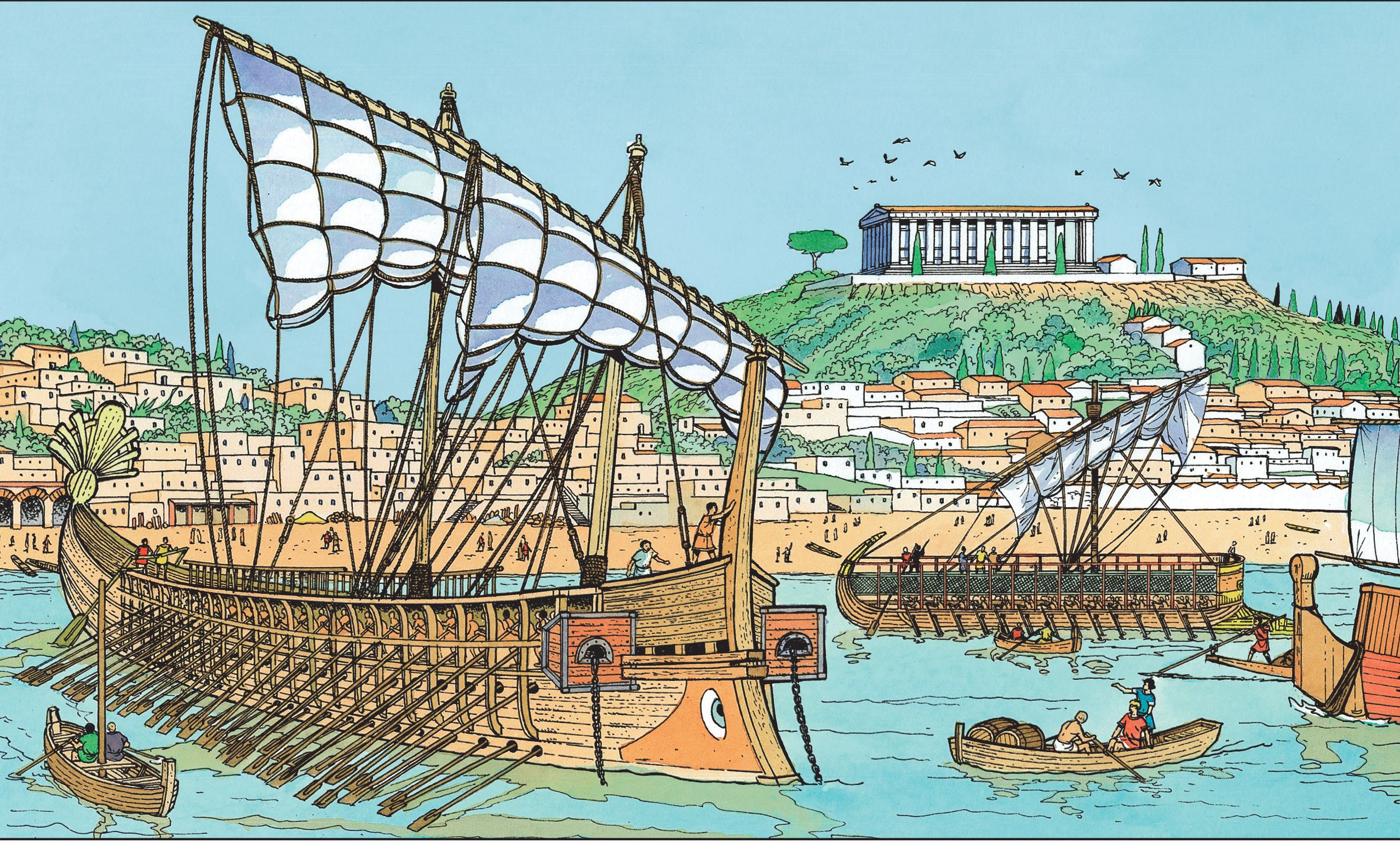
Sailing remained in the ancient Phocaeans' blood. A good example is one of the most famous citizens of Massalia whose statue can be seen to this day on the façade of the stock exchange building in Marseille. I am referring to Pytheas of Massalia, a Greek merchant, explorer, geographer and astronomer from the 4th century BC.
Phyteas made mathematical instruments that allowed him to determine almost the exact latitude of Marseille. He was also the first scientist to realise that the tides at sea were related to the position of the moon.
Between 330 and 320 BC, he organised an expedition across the Atlantic to the north of England, Iceland, Shetland and Norway. By doing so, he hoped to establish a sea trade route for tin from Cornwall7. However, the Massilians found it cheaper and easier to trade with northern Europe over land routes8.
Massalia remained an independent Greek state for a long time but felt threatened by an invasion by Gallic tribes in 218. It made an alliance with Rome and received protection from the Romans in exchange for a strip of land across its territory, intended for the construction of the via Domitia, a road to Spain. The city still maintained its independence, but the Romans built their province of Transalpine Gaul around it and founded the colony of Narbo Martius9 in 118 BC.
The latter city would become a major economic competitor of Massalia.
During the Roman civil war between Julius Caesar and Pompey in the 40s BC, Massalia initially tried to remain neutral. When Caesar, en route to Hispania, wanted to call at Massalia, the city gates remained closed. When negotiations did not help, Caesar decided to lay siege to the city. After much resistance, several defeats, famine and an outbreak of plague, the inhabitants surrendered to Caesar.
The fall of the city marked the end of Massalia's prosperity and independence for that moment. The city retained its theoretical status of civitas foederata (ally), but had to relinquish its fleet, war chest and much of the territories around the city11.
After the surrender, Massalia would no longer play an important political role and was surpassed by Narbo Martius (Narbonne) and Arelate (Arles).
The city was now largely under Roman rule but adapted well. The statesman Titus Annius Milo, then living in exile in Marseilles, joked that no one would miss Rome as long as they could eat Marseilles' delicious red mullet.
Caesar, out of respect for its long history, allowed Massilia to continue to exist and in the following centuries, during which the Romans stayed in Provence, the city would once again flourish.
Massilia gradually became a Roman city although Greek influences would remain present for a long time. However, structures from the original Phocene settlement were replaced or received Roman additions. Ancient monuments were demolished with the stones often being reused in newly built structures. This would be repeated continuously throughout the centuries. The more successful the city became the more it expanded and old buildings went down for new to build constructions. This is perhaps the reason why today, at first glance, very little remains of its long Greco-Roman history.
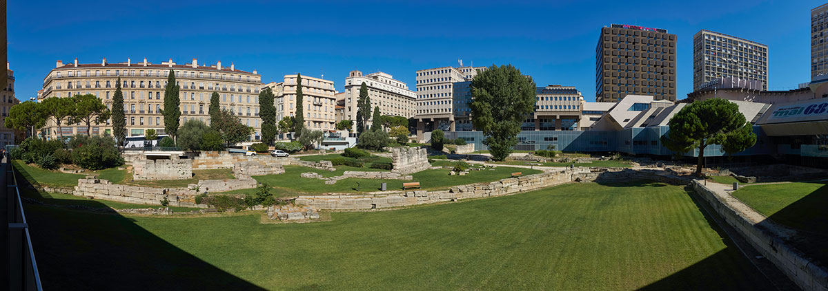
The remains of the ancient city
"Despite its wealth, power and progress in civilisation, the ancient city has left no remains of buildings or traces of its existence except inscriptions (some in Greek), sarcophagi and a few fragments of sculpture." ” This is what the British publisher John Murray III wrote about Marseilles in 184312.
Indeed, over the centuries there has been bitterly little interest among the inhabitants in the ancient history of their city, this despite the efforts of some scholars.
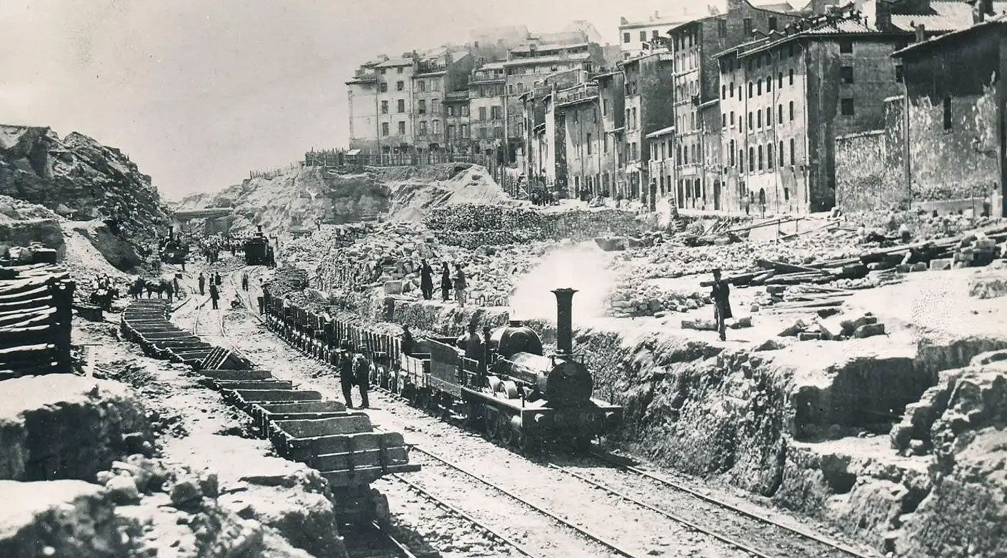
Between 1862 and 1864, notwithstanding Napoleon III's personal interest in archaeology, the heart was torn out of the old city over a length of 1 kilometre for the construction of the 'rue Imperiale' (the later 'rue de la République'). As a result, irreparable knowledge was lost because a study of the area was not carried out first.
as it existed in the 1st century BC14.
As recently as 1949, Benoit wrote:"......of ancient Massalia, very little is still known: the remains of a Christian religious building; the location of some cemeteries; the substructures of some Roman horrea (warehouses) near the port; the few remains of a theatre; a large Ionic capital; a few Latin and Greek inscriptions; a collection of shrines dedicated to Cybele and a fairly extensive group of Greek shards 16.
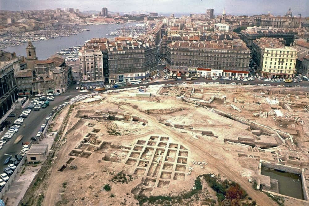
The big breakthrough came in 1967 when, during excavations for the foundation of a large shopping centre, old walls from various periods were uncovered, including remains of the eastern city gate and of some facilities immediately beyond it, near the inner part of the harbour. Intervention was made by the Administration of Antiquities, which temporarily secured the area, but the costs demanded by the municipality were so high that sufficient funds to conduct a detailed survey were not available.
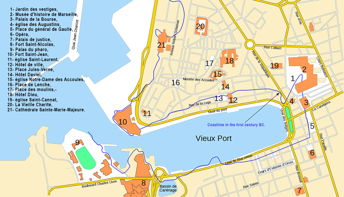
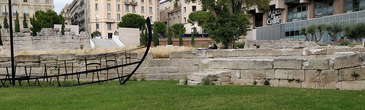
Several of these finds have been reconstructed over the years and placed in a specially equipped park, the 'Jardin des Vestiges' 18 (see figure 1, 13 and 17).
The Harbour
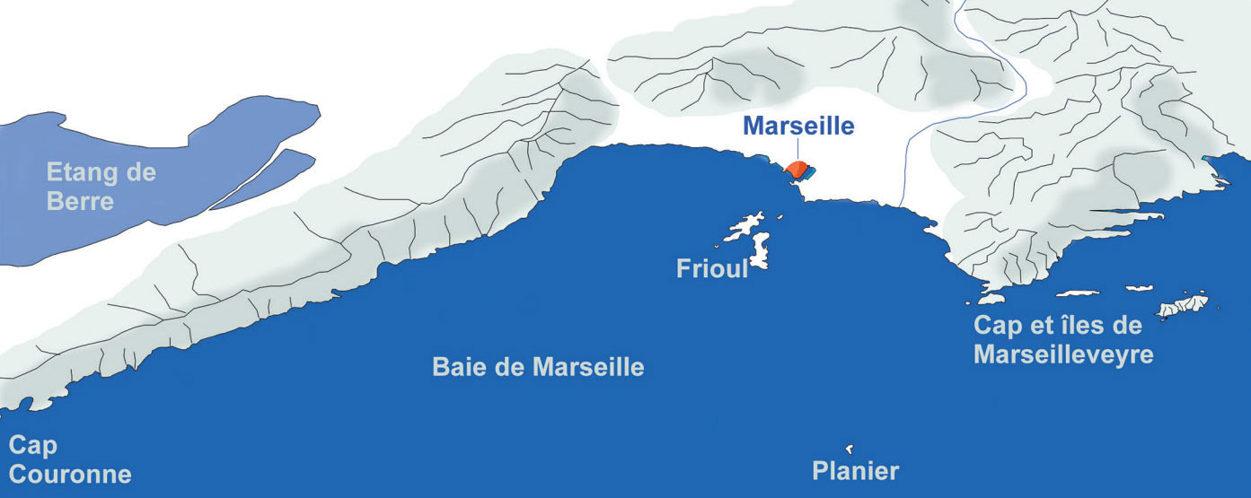
Marseille's roadstead is located between the capes of Marseilleveyre and Couronne. The bay is dotted with small islands and rocks. This makes entering Marseille a delicate undertaking. The biggest danger here is the islet of Planier, some eight nautical miles off the coast. This islet hardly rises above the water and has therefore caused many shipwrecks since ancient times.
The Bay of Marseille had many hiding places, especially between Cape Couronne and Marseille. This sector was important for access to Lake Berre, the Rhone, Languedoc and the quarries of Spain, which were more accessible by sea than by land.
Also on the other side of Marseille at the cape of Marseilleveyre were several islets that provided good protection from the sea and mistral winds. They more or less served as outports of Marseille. Not only in case of emergency but also to wait for the best conditions to sail out to Italy, Spain or North Africa.
Knowledge of the harbour and its hazards was therefore extremely important for any sailor who wanted to sail to Marseille. It was all the more important because the Calanque du Lacydon (The Bay of Lacydon) is hidden from the roadstead by the promontory and can only be seen when sailing close to it in the shallow waters dotted with rocks.
La calanque du Lacydon
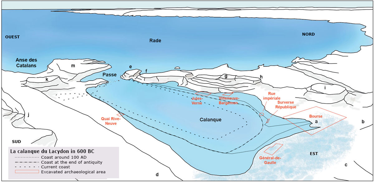
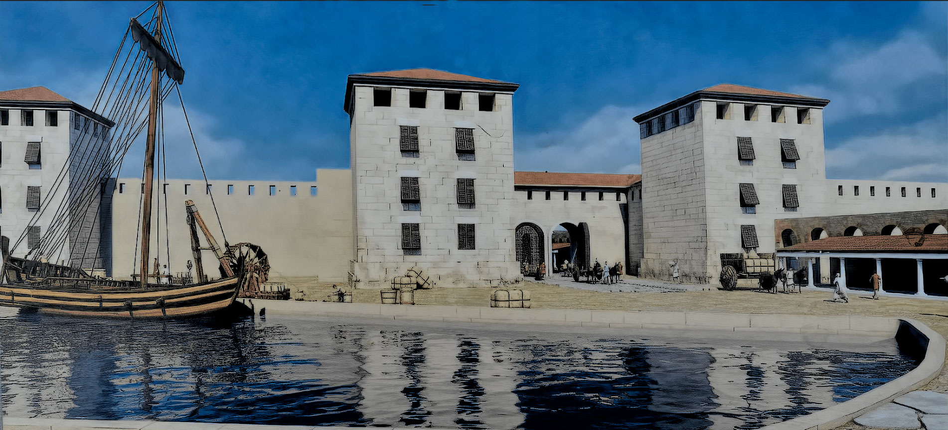
The entrance to the port of Marseille curves between the promontory of the lighthouse (figure 10m) and the promontory of Saint-Jean (figure 10e). The entrance used to be dotted with rocks and reefs. These have now disappeared but were still mentioned in archives in the Middle Ages19.
The situation made entering the bay, and certainly the entrance to this inlet, difficult but it also provided double protection. The swell from the sea almost never penetrated the bay and anything and everything that wanted to enter the port through the pass was easily controlled from the two promontories.
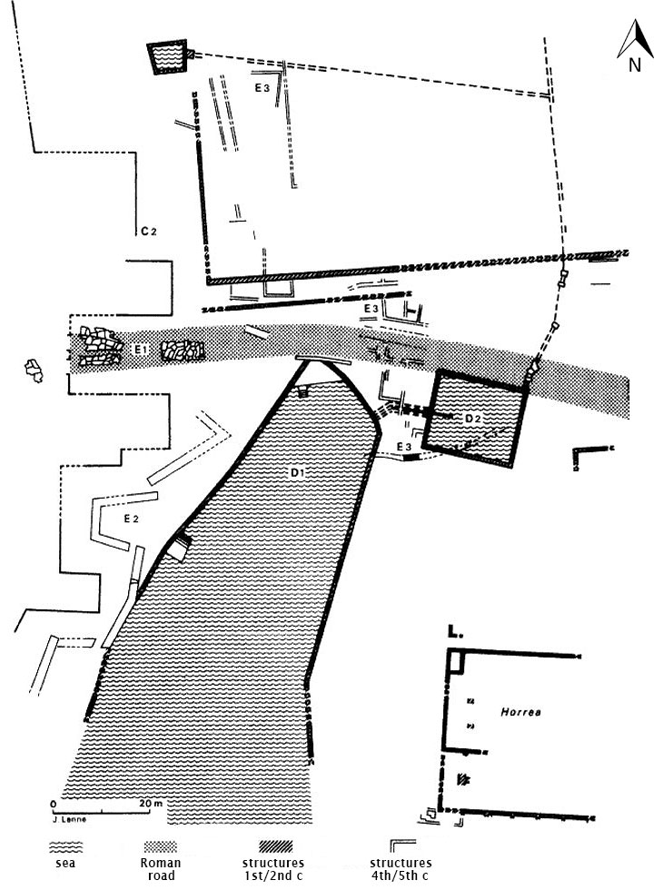
Next came the calanque of Lacydon (figure 10). This basin was roughly rectangular in shape, but receded slightly to the north to form a 'horn' (La Corne) (figure 10a).
The first harbour development discovered in the course of the excavation dates back to the first quarter of the sixth century BC. It was a jetty discovered at Place Villeneuve-Bargemon (see Figure 10). The base of this jetty was littered with amphora remains and imported pottery. Excavations in that area also revealed a lot of shipbuilding.
In the 3rd century BC, roofed docks were built on the beaches of Place Villeneuve-Bargemon, where shipbuilding took place. These were usually for warships. At Place Jules-Verne (Figure 10), there were unroofed slipways for ships.
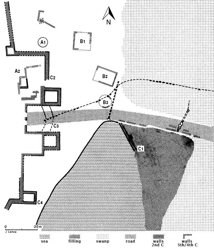
In the northwest of the excavation area, a large round well (figure 12 A1) with a diameter of 6 metres as well as several walls (figure 12 A2), which may have been part of the very first defensive walls from this period, were found.
Somewhat later, the road between the sea and the marsh was considerably enlarged. In the north, several terraces (B1, B2, B3) were found with cremation cemeteries dating from the 4th century BC.
In the south, carved stone footings supporting the road along the coast were discovered, as well as the remains of wooden quays on which small boats could be pulled out of the water. Certainly not large ships as the water there was too shallow.
French archaeologist Camille Jullian20 named the spring after the 'Sacred Stream of the Massiliotes'21, Lakydon. This name became the symbol of the port22.
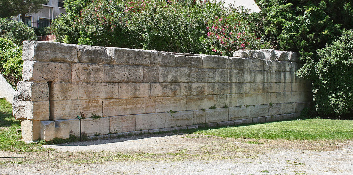
The most spectacular construction from the Hellenistic period is certainly the wall that ran along the western side of the excavations. Parts of this wall were discovered during the demolition of the city in the early 19th century. The wall is now exposed on both sides of the western gate over a length of more than 200 metres and was protected by two large towers, one of which still stands exactly in its original place and the other has been partially moved upwards.
The wall was constructed with so-called emplekton technique23, about 3 metres thick, with the visible face formed by blocks from the Cape Couronne quarry24.
Black glazed pottery of medium quality was found in the trenches of the foundation, which gives a dating of just before the middle of the second century BC. It seems that this wall was not destroyed or demolished after Caesar's victory and conquest of Marseille in 49 BC because it was partially reused in the late antique fortification see Figure 12).
Research did reveal that by Roman times, the aforementioned docks and slipways had disappeared under the embankments on which buildings with indeterminate functions were erected. A small quay lined with piles seems to have been newly built between two of these buildings below Place Jules-Verne.
Some 70 metres from the existing quay along the north bank of the Vieux Port, the remains of an identical quay were found that ran to the beginning of the access channel 26.
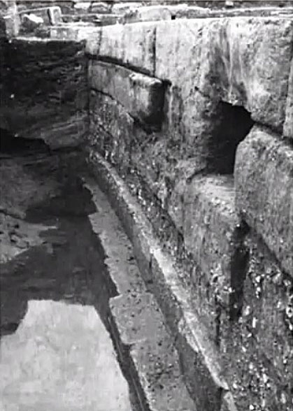
However, the inner harbour was in constant danger of silting up. The freshwater spring itself brought a lot of pollution. Therefore, a temporary settling basin was constructed around the middle of the second century (Figure 14 D2). The spring water was now directed through this settling basin where the entrained sediment sank to the bottom and the clean water flowed into the harbour-basin through two holes at the top. The basin therefore also had to be regularly dredged.
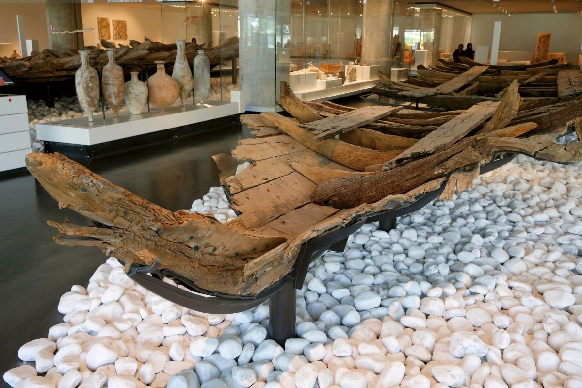
The silting up of, in particular, the north-eastern part of the inner harbour continued steadily despite the new basin and finally, at the end of the second century or, at the latest at the beginning of the third century AD, the inner harbour was abandoned.
It had now become a ship graveyard where several interesting finds were unearthed, including a well-preserved ship's hull that is on display at the 'Musée d'Histoire de Marseille'.
To date, no trace has been found to date the repairs to the city wall (Figure 14 E2), which included parts of the Hellenistic fortification as well as part of the Roman quay for which a moat had been dug. We can only be sure that the ancient marsh reappeared at the site of the ancient harbour and that, according to analysis of its deposits, it must have produced an unhealthy atmosphere.
For the harbour structures at the end of the Republican period and the beginning of the Empire, the situation is rather unclear and no archaeological evidence has been found. This is probably due to the fundamental reorganisation in the 1st century AD, which erased the levels that immediately preceded it. However, several ancient records show that Marseille remained important to the Romans even after the defeat of 49 BC, and the exposed harbour installations also prove this.
The Augustan period seems to have been dominated by the development of the entire coastline. In the middle of the southern bank, at 23 quai de Rive-Neuve, an inlet was drained (figure 17 c). Further west, on the same southern bank at Fort Ganteaume, heavy seawalls were exposed (17 d), with ceramics emerging from the water dating from the 5th to the 1st century BC 28.
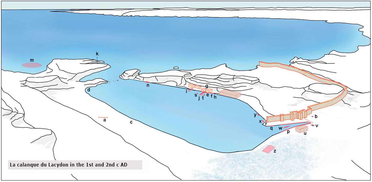
The north bank was dredged 2 metres deeper after which two quays were built east of the mouth of a stream. One consisted of a masonry structure bounded by a wooden wall (17 e) and the other of a small wall on a foundation of pozzolanic concrete (17 f). Near this quay were two warehouses, one of which was intended for dolia (large bulging jars).
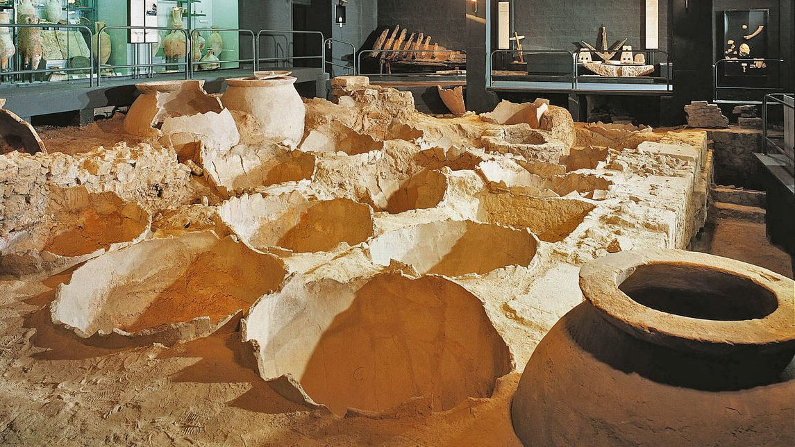
During excavations of the Place Villeneuve-Bargemon, they came across extensive thermal baths and at the Docks site another dolia warehouse (the current "Musée des docks romains") was found with a wharf in front of it (17 i). Towards the old rue Mayousse, a hardstone quay wall (17 n) was discovered from the second half of the first century AD.
In La Corne (the inner harbour) a stone quay wall emerged around 70 AD (16 p). Near the Rue de la République too stone quays appeared (17 q and r).
These major building activities can only have had an economic and commercial purpose. Arles and Marseille operated side by side and had different functions. Arles was a city on a river and a trade route; Marseille was a city by the sea.
Found pottery and coins show that in the late 2nd century AD, grain from the central Rhône valley was shipped continuously to Rome. In the periods that followed, the city and thus the port would continuously expand and adapt to the needs prevailing at the time. Marseille's port was important to its ancient inhabitants, Phocenes, Greeks and Romans, and it still is today, 2,700 years later, to Marseille's current inhabitants. Fortunately, the realisation of the value of that long history has entered the Marseillais, albeit somewhat late. So, in the near future we may hope to learn a lot more about the past, and for us special the Roman past, of the "CITÉ PHOCÉENNE".
- Sources
- - Le complexe portuaire antique de Marseille - Xavier Corré (2021)
- - Nouvelles réflexions sur ‘la corne du port’ (site de la Bourse) et son intégration au complexe portuaire de Marseille romaine – Pawlowicz (2023)
- - Ancient Marseille in the Light of Recent Excavations – Maurice Euzennat (1980)
- - Wikimedia.org/wiki/History_of_Marseille
- - www.marvellous-provence.com
- - Arthur de Graauw – AncientPortsantiqes.com
Notes- 1: Commons.wikimedia.org - Celuici
- 2: Herodotus, 1.163
- 3: Celtic-Ligurian tribe
- 4: Justin XLIII, 3 = Pompeius Trogus. Filippische Historiën (vert. Rivet 1988, p. 10).
- 5: Massalia.weebly.com
- 6: Tetrobol (2/3 Drachma). On the left bust of Artemis; on the right a lion with the text ΜΑΣΣΑ-ΛΙΗΤΩ[N]
- 7: Read for British tin "Ictis".
- 8: Palanque 1990, p. 44.
- 9: Read our article "Narbonne, gate to the Celtic world"
- 10: Illustration Gilbert Bouchard
- 11: Cassius Dio - Roman history 41.25
- 12: John Murray 1808-1892 - handbook for Travellers
- 13: Photo – Archief LaProvence.com
- 14: Illustration: Robert Valette
- 15: Fernand Benoît, 1892-1969, researcher 'le Vieux Port' and study stratigraphy of Lacydon as well as discovery and excavation of the docks.
- 16: Benoit “The new excavations at Marseille” AJA 53 (1949) 237-40
- 17: Photo: www.madeinmarseille.net
- 18: The remains do not exactly reflect the original locations, partly because they were found at different depths in the ground.
- 19: Corré 2009, 151-153 and 204-207.
- 20: Camille Jullian (1859 –1933) a French historian, philologist, archaeologist and literary historian.
- 21: Inhabitants of Massalia.
- 22: C. Jullian, “Le port du Lacydon et le ruisseau sacré des Marseillais, ”Provincia 1 (1921) 1-6
- 23: Technique where the walls were only nicely finished on the outside and filled inside with grit and earth to make them stronger.
- 24: Quarries 25 km west of Marseille.
- 25: Photo: Robert Valette
- 26: F.Benoit, Musée des docks romains et du commerce antique Marseille (Marseille 1965).
- 27: Photo: Archives SRA, 1968-69. No 148
- 28: CAG 13/3, 666-667
- 29: Photo: Arthur de Graauw


 We are committed to providing versions of our articles and interviews in several languages, but our first language is English.